Eric Gaba (Wikimedia Commons user Sting), CC BY-SA 3.0, via Wikimedia Commons
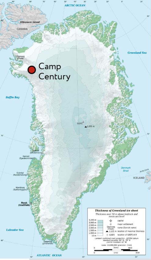
In the 1960s, during the Cold War, the U.S. built an Arctic research center in Greenland and called it Camp Century.
Except it was actually a secret military operation—code name: Project Iceworm.
It was intended to drill a network of nuclear missile launch silos in the Greenland Ice Sheet, designed to survive a Russian ‘first strike.’
The first people there were researchers, to test the ice for suitability. They drilled nearly a mile through the ice sheet and 12 feet into the soil below.
Their studies revealed the ice was flowing much faster than expected. The launch tunnels, and the missiles within them, would be crushed within 2 years.
Of the planned 2,500 miles of tunnels, only 2 miles were built before the base was scuttled. Years later, the project and the ice cores they drilled have been declassified.
And they’ve revealed something else. The Greenland soil wasn’t always under ice!
Judging from sediment found with the plants, 416,000 years ago the area was ice-free during a warm interglacial period.
The ground was exposed for more than 10,000 years at this location. Then it froze over when the glaciers returned—and has been buried under ice ever since.
Project Iceworm may not have produced a missile base. But it did yield important evidence for scientists studying Earth's natural glacial and interglacial cycles.
Background
Synopsis: A once-secret project below a U.S. Arctic military base in northwestern Greenland was scuttled in the 1960s because of unstable ice. Sounds like a spy thriller, but it really did produce a 4,560 ft (1,390 m) core of ice with 12 ft (3.66 m) of Pleistocene soil from below the ice. Scientists recently determined that the soil had been exposed to sunlight during an interglacial period for just 14,000 years about 416,000 years ago, indicating that the edge of Greenland’s ice sheet in this area retreated from the coast then advanced back over the site as glacial conditions resumed. This cyclical Pleistocene glaciation produced ancient sea level change.
- During the Cold War, military rivals the United States and Russia were constantly scheming to outwit the other side, resulting in a top-secret U.S. operation in Denmark’s territory of Greenland known as Project Iceworm that had a widely publicized cover operation known as Camp Century.
- Around 1960, Camp Century was touted as a demonstration of ice construction techniques to build a nuclear-powered Arctic research center, located 138 mi (222 km) inland from Greenland’s western coast at an elevation of about 6,600 ft (2,000 m) above sea level.
- But documents declassified in 1996 revealed that Project Iceworm was an undisclosed Pentagon program with the goal of building a web of tunnels with hundreds of underground nuclear missile launch pads below the ice sheet at Camp Century that could survive a “first strike” from the Russians.
- After three years, of the 2,500 mi (4,000 km) of tunnels planned, only 1.9 mi (3 km) had been built, but these tunnels housed as many as 200 residents and were powered by a portable nuclear power plant.
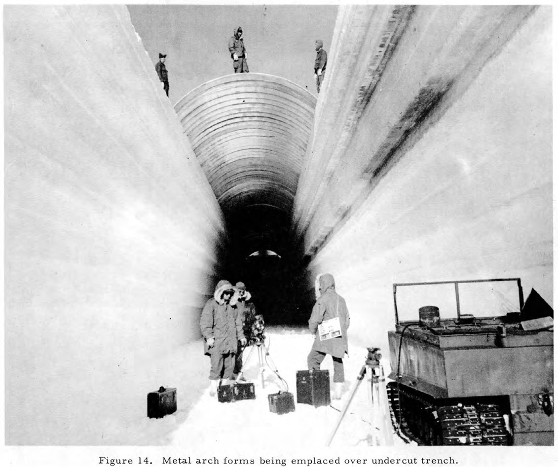
Camp Century trench construction in 1960.
Credit: U.S. Army Corps of Engineers, Cold Regions Research and Engineering Laboratory, public domain, via Wikimedia Commons - Around that time, geologists working at Camp Century took ice cores that demonstrated the ice was flowing much faster than expected. They predicted that the tunnels and launch stations would be crushed within about 2 years.
- The research camp was evacuated, the nuclear generator was removed, and Camp Century and its secret underground project were closed down in 1966.
- The deployment of missiles to Greenland never occurred, and the topic was never broached with the host government, Denmark.
- While they were building tunnels, geologists were also drilling down through the ice sheet to determine how thick it was at the Camp Century location.
- They drilled through 4,560 ft (1,390 m) of ice, around seven-eighths of a mile (1.4 km) thick.
- Then they drilled another 12 ft (3.66 m) into the ancient soil beneath the ice.
- By 1969, the ice core and soil below it had been described by a geophysicist named Willi Dansgaard.
- For the next 30 years, the core was pretty much forgotten, until Danish scientists found the core in a freezer in Copenhagen.
- Scientists knew from the perfectly preserved fossil plants just below the ice that this part of Greenland had been ice-free in the past million years, but when was it ice-free?
- Scientists used a technique called optically stimulated luminescence (OSL) dating to determine the last time the center of the core had been exposed to sunlight.
- As sediments age, radioactive minerals within them decay, producing electrons that are trapped within quartz crystals until sunlight releases them.
- OSL showed that the area below Camp Century was ice-free around 416,000 years ago during a strong interglacial period known as Marine Isotope Stage 11, which lasted from about 424,000 to 374,000 years ago.
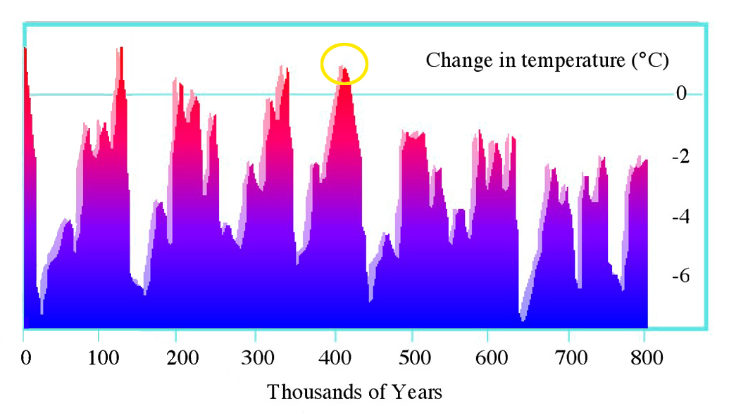
This graph of Earth’s mean global temperature for the past 800,000 years shows the sawtooth shape of Pleistocene glacial lows and interglacial highs. The warm spike at around 420,000 years ago is coincident with the plant material found in the Greenland ice core from Camp Century.
Credit: Hannes Grobe/AWI, CC BY 3.0, via Wikimedia Commons - Scientists at the University of Vermont employed radioactive isotopes of aluminum and beryllium to work out that the sediment retrieved in the core had only been exposed to cosmic rays for 14,000 years at most.
- These clues suggest that the ice sheets of Greenland waxed and waned during Pleistocene cycles of glacials and interglacials.
- We don’t know the extent of the ice sheet that existed prior to the development of the 416,000 year old soils, so we don’t know how much ice had to melt in order to expose the ground surface.
- If ice-free all the way to the coast, this sample of mossy, scrubby forest floor from 138 mi (222 km) inland could indicate a volume of ice melt that could result in sea level rise of 5 to 20 ft (1.5–7 m).
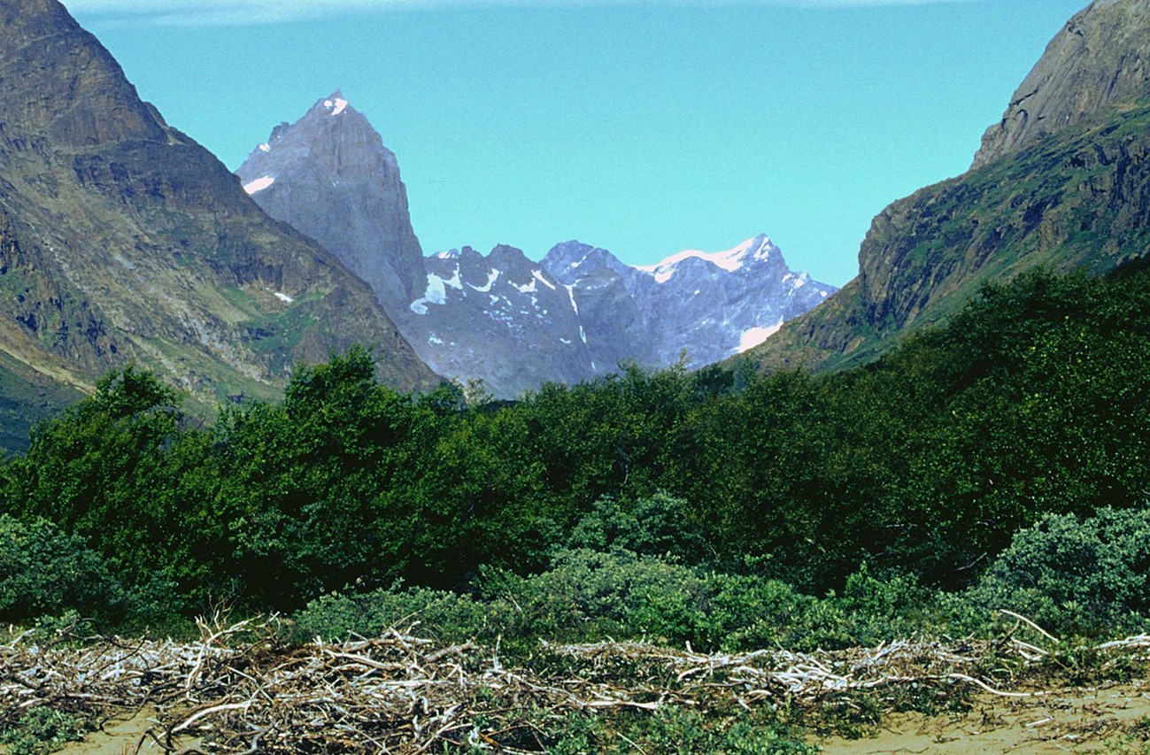
The Qinngua Valley at the southernmost tip of Greenland has scrubby forests and tundra and may resemble the type of landscape indicated by the ancient soil found below Camp Century.
Credit: Svickova, public domain, via Wikimedia Commons - Alternatively, the site could have been a smaller open “window” in the ice sheet disconnected from the coast that would produce a lower volume of ice melt and sea level impact. Scientists are still working out the implications of the discovery.
- But one thing is certain: since the time of soil exposure, the area has been buried by nearly a mile of younger glacial ice.
- See more on EarthDate about Greenland: ED-117 Green Iceland/Icy Greenland and ED-189 Under Greenland’s Ice.