Credit: NASA/Joe MacGregor
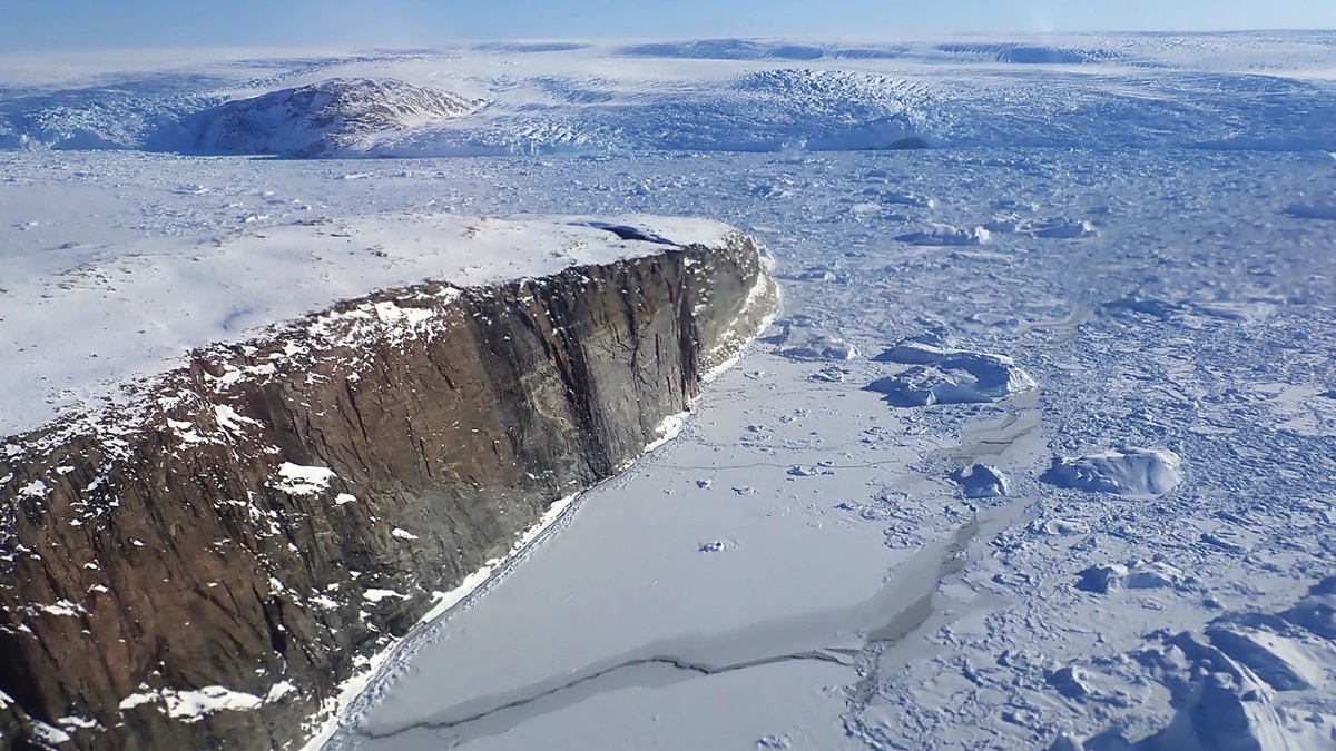
Greenland is Earth’s largest island, and most of it is covered by ice up to 2 miles thick.
Scientists decided to investigate the age of this ice sheet and were surprised to find that not that long ago, there wasn’t one.
They used ice cores to date different areas, then flew planes over it with special ice-penetrating radar.
The radar identified bands of softer and harder ice and layers within them, which they matched to the ice cores to determine different ages of ice across the island.
Turns out Greenland’s ice accumulated in three separate events: the oldest beginning 130,000 years ago; the middle one during the last Ice Age; and the most recent just 12,000 years ago.
Equally interesting, the radar revealed the bedrock beneath the ice sheet to find that a giant rift as deep as the Grand Canyon and even longer, at almost 500 miles, splits the island and exits north into the Arctic Sea. It’s possible this was formed by massive floods as much as 2 million years ago.
They also found a huge impact crater that appears to have been made by a mile-wide meteorite, which might be the one that caused the lingering Ice Age discussed in a previous episode. It’s unclear when it struck Earth, but it was at least 12,000 years ago, since the young ice above it is undisturbed.
This new technology has given us a remarkable first look at Greenland’s landscape, otherwise hidden beneath the ice.
Background
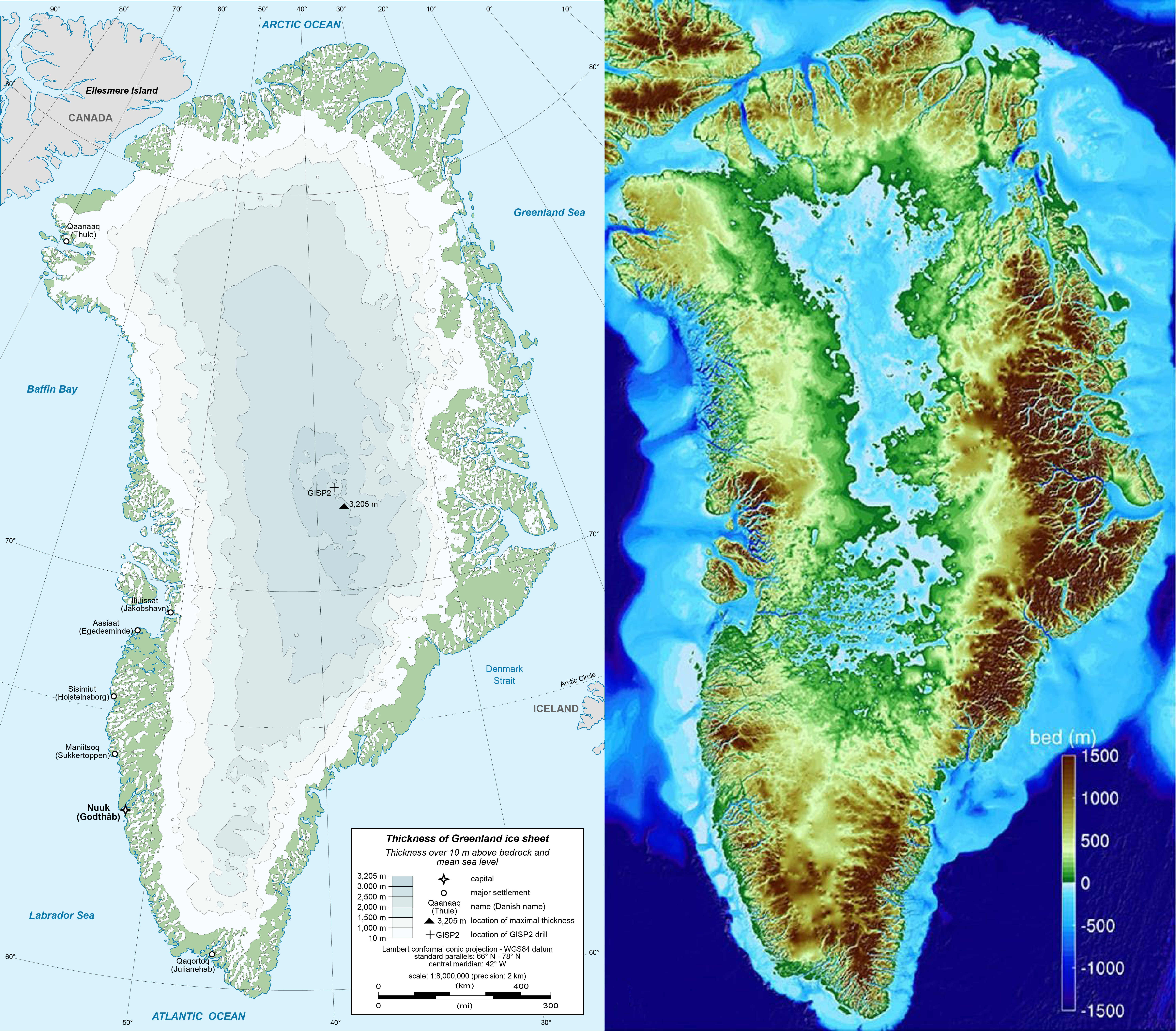
Synopsis: Three-quarters of Greenland is covered by a permanent ice sheet that is up to 2 miles (3205 m) thick. In Operation IceBridge, scientists used ice penetrating radar to see what is hiding beneath Greenland’s ice, imaging multiple layers of ice, deep canyons, and a probable impact crater.
Credit: Eric Gaba (CC BY-SA) and AGU/GRL/UC Irvine
- Greenland is the world’s largest island, situated in North America between the Atlantic and Arctic Oceans.
- It is an autonomous territory of the Kingdom of Denmark, so it tends to be more European than American from a cultural standpoint.
- Most of its citizens are Inuit, having settled there from Alaska and northern Canada in the 13th century.
- Although it is about three times the size of Texas, Greenland has the lowest population density in the world. Is population was only 56,081 in 2020, and about a third of its population lives on the southwestern coast in the capital of Nuuk.
- The northernmost military base in the world is the Thule Air Base in the settlement of Qaanaaq, in the extreme northwest of the country. Just 930 miles from the North Pole, it is home to the US Space Force’s 21st Space Wing.
- Greenland’s ice sheet is 2 miles thick at its center and covers 677,855 mi2 (1,755,637 km2).
- If the whole ice sheet melted, scientists estimate it would raise global sea levels by 24 ft (7.5 m).
- The ice sheet lost 1 trillion tons of water between 2011 and 2014.
- The ice sheet is so heavy, it has depressed the portion of Earth’s crust lying underneath, causing the center of the Greenland to rest nearly 1000 ft (300 m) below sea level.
Credit: NASA
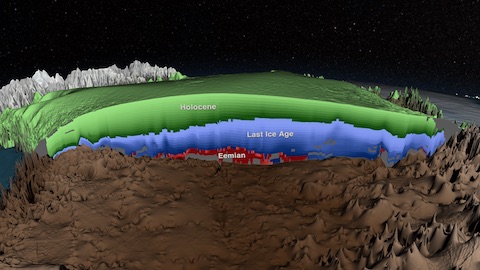
- Scientists recently discovered that Greenland’s ice accumulated across three distinct events over a period of more than 130,000 years.
- NASA’s Operation IceBridge used airborne ice-penetrating radar data to view layers deep inside the Greenland Ice Sheet.
- Radar signals are transmitted from the plane into the ice, where they reflect back differently across harder and softer layers. This lets scientists detect the ice surface, the bedrock below the ice, and multiple layers within the ice.
- Combining this data with what they know about Greenland’s ice layers from ice core data, scientists can determine the age of the layers at certain locations and then trace the layers around the ice sheet using the radar data.
- The oldest layer they have been able to map dates to the Late Pleistocene Eemian (130,000 years ago to 115,000 years ago).
- Many scientists expected Greenland’s ice sheet to have formed in the early Pleistocene, but it is much younger, with its oldest layers having formed during the most recent warming event that took place before our current Holocene warming. So Greenland must have been ice free during parts of the Pleistocene.
- They created a 3D model of the layers to help them understand how climate changes have impacted these ice sheets over the past 130,000 years. This helps scientists to better describe the history and volume of the ice sheet and to anticipate how the ice might respond in the future.
- Another NASA program, Ocean Melting Greenland (OMG), surveyed the edges of the ice sheet using ocean sampling and airborne radar in more than 200 fjords.
- Researchers determined that many of the coastal glaciers intersect bedrock at more than 200 ft (61 m) below sea level.
- This allowed for greater exposure of the ice to seawater, which is a few degrees warmer than Greenland’s frigid surface water. This warmer sea water likely accelerates glacial retreat compared to prior expectations.
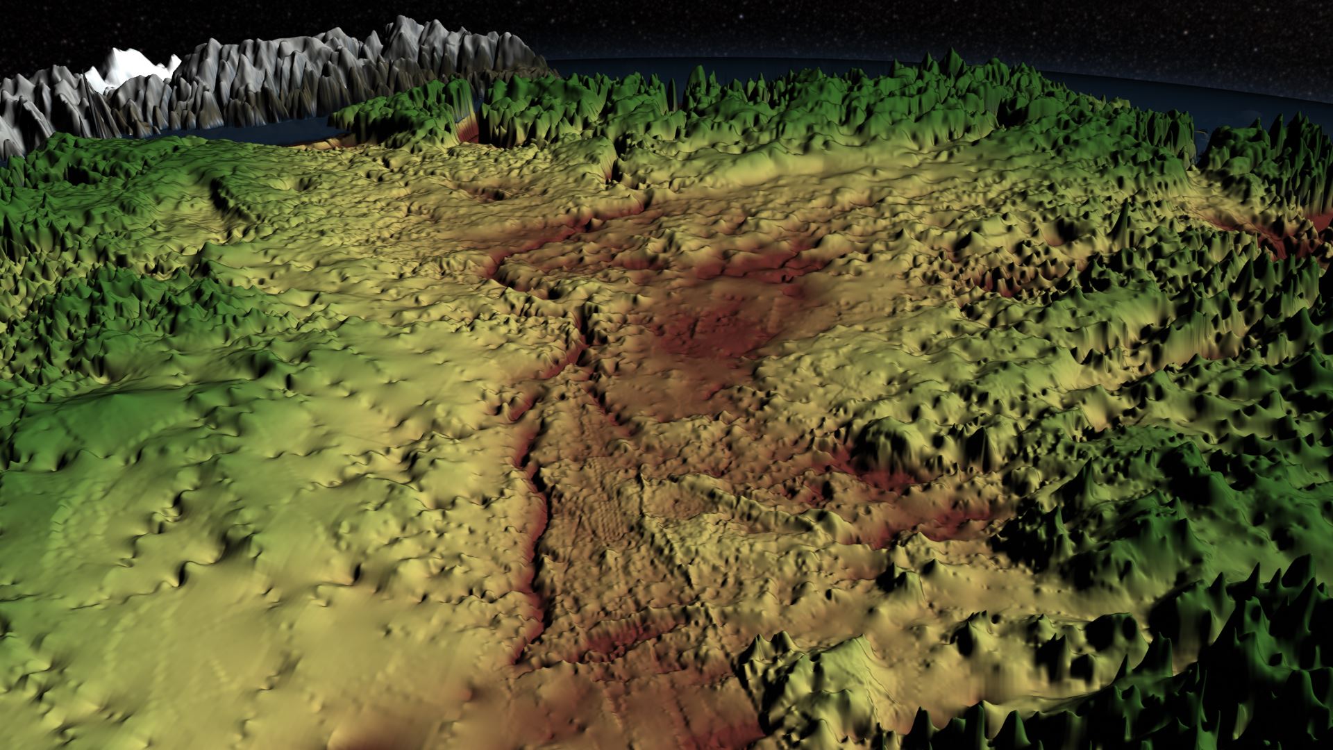
- Between these two NASA missions and airborne radar campaigns led by the UK and Germany, enough data was collected to produce a three-dimensional map of Greenland’s land surface.
- The map depicts what Greenland would look like without its ice, with many islands, both large and small, and a few other surprising features.
Credit: NASA
- The 3D map shows a deep complex of canyons below the ice that is thought to have formed as fluvial channels before the oldest existing Eemian ice sheet formed.
- The main canyon is as deep as America’s Grand Canyon and much longer at 460 mi (750 km) long—twice the distance from Washington DC to New York City.
- The canyon exits the island northward into the Arctic Ocean via the fjord of the Petermann glacier across the Nares Strait from Canada’s Ellesmere Island.
- The canyon and its tributaries may have been so deeply excavated because of catastrophic outburst floods that would have occurred during earlier Pleistocene intergalcial melting episodes.
- Alternatively, they might have been carved by glacial movement. However, the shape of the tributary channels is fine and branching, which is uncharacteristic for glacial valleys.
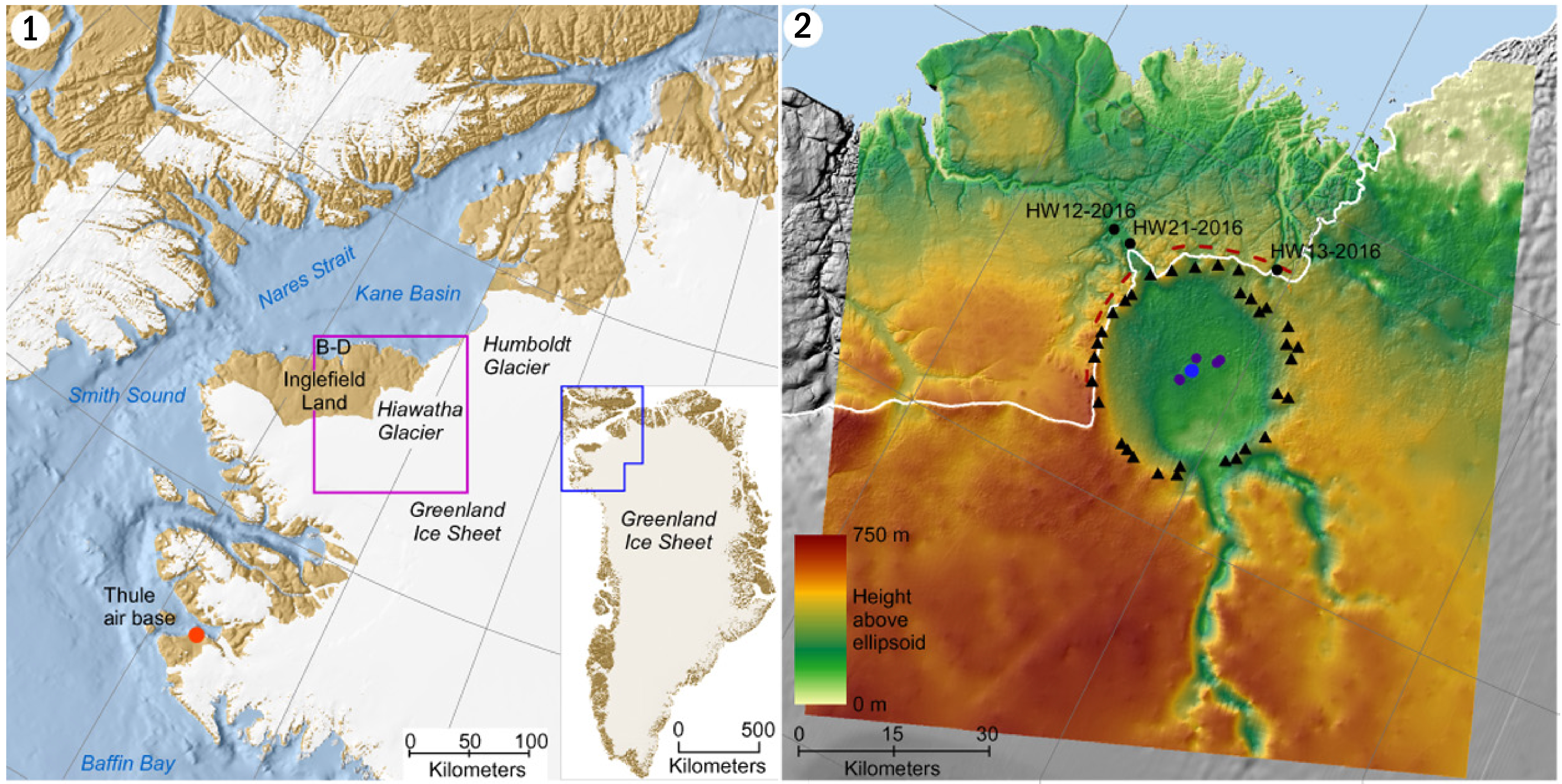
Credit: Kurt H. Kjær (Centre for GeoGenetics, Natural History Museum, University of Copenhagen, Denmark)
- The Hiawatha Glacier is a semicircular feature at the northern edge of the ice sheet, to the west of the Petermann glacier. In 2015, it had some curious scientists in Denmark scratching their heads.
- They orgainzed an investigation using detailed ice-penetrating radar and found a circular depression 19 mi (31 km) in diameter—larger than the cities of Washington DC or Paris.
- The size of the depression suggests a meteor nearly a mile (0.9 mi, 1.5 km) across slammed into Earth at that location, wreaking havoc in the Northern Hemisphere.
- The age of the crater is not yet known, but the radar data suggests ice deposited since the start of the Holocene 11,700 years ago is not disrupted, so the impact must have occurred before then. Could this crater be a candidate for the impact that may have driven the start of the Younger Dryas that we discussed in the previous EarthDate episode?
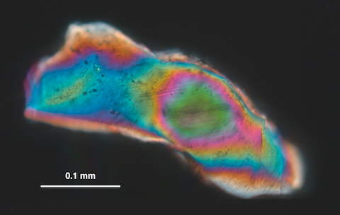
- Since the crater is below the ice, it is difficult to sample, but scientists have collected many different types of data, including sediment samples from the river that flows out from under the glacier. They found shocked quartz grains which may indicate an impact. They also found high concentrations of nickel, cobalt, platinum, and gold.
- However, scientists need to do more work to decide what the depression represents—you’ll be hearing more about this story in the future.
Credit: Natural History Museum of Denmark, Cryospheric Sciences Lab/GSFC/NASA
- And finally, one last fact about the Greenland ice sheet; though it’s something we may never want to find, we have to be aware of it: In January 1968, a United States B-52 bomber with four nuclear bombs onboard crashed on the ice in North Star Bay during an emergency landing at Thule Air Base. The crash caused radioactive contamination, and one of the hydrogen bombs has never been recovered.