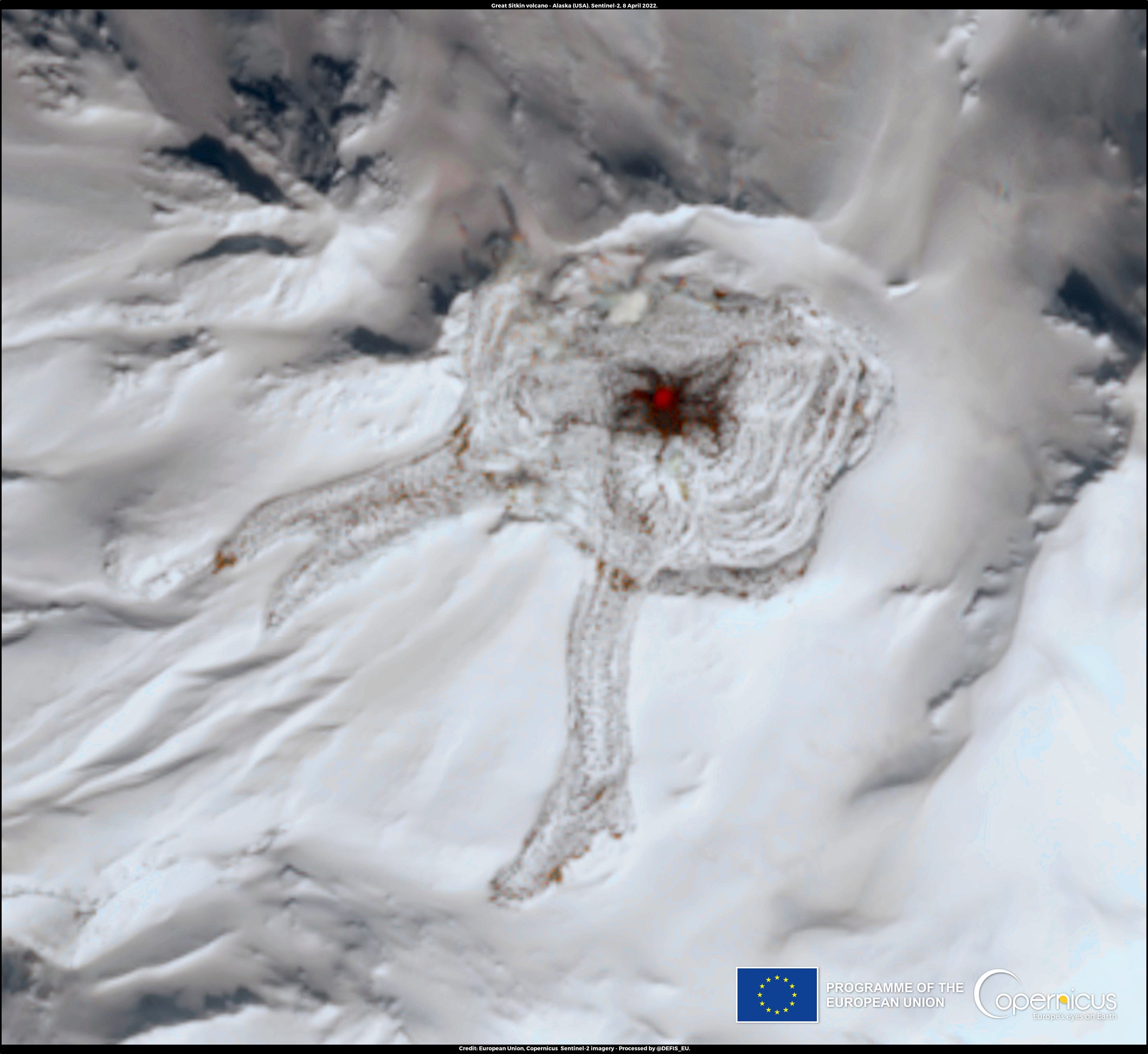
Credit: European Union, Copernicus Sentinel-2 imagery
Two of the most powerful forces on Earth are glaciers and volcanoes. What happens when they collide?
One dampens the other. And one makes the other more dangerous.
During the most recent ice age, glaciers covered a third of Earth’s surface. During this time, volcanic activity declined …
Because the sheer weight of ice pressing down on the land increased the pressure on Earth’s mantle beneath the crust.
The higher pressure raised the mantle’s melting point, so that the fiery temperatures couldn’t melt it as easily to form volcanoes.
When the ice age ended and glaciers retreated, the surface rebounded. Pressure on the mantle decreased, and it was easier to melt into magma, which erupted on the surface as volcanoes.
Even today, when volcanoes occur at high latitudes, glaciers can moderate their activity.
On the other hand, when a volcano does erupt beneath a glacier, it can melt it from the bottom up. Steam hollows out a huge chamber inside the glacier, which fills with millions of gallons of meltwater.
As the lava continues to flow, it melts more ice, until it eventually breaches the top of the glacier or forms a lava tunnel within it. And all that water is catastrophically released.
These so-called “glacial outburst floods” are powerful and often unexpected and therefore can be very dangerous.
So who wins in this epic power struggle? Glaciers beat volcanoes. Until volcanoes beat glaciers.
Background
Synopsis: Two of the most powerful geological forces on Earth are volcanism and glaciation. In high-latitude tectonically active regions, the sheer weight of glaciers can moderate and modify volcanism, while volcanic eruptions can melt snow and ice, unleashing hazardous glacial outburst floods. Subglacial volcanism is active in Iceland, British Columbia, and Alaska, but it also occurs below the ice sheets of Antarctica and possibly on Mars.
- Volcanism and glaciation are processes with the power to change Earth.
- Recent eruptions (ED-298 Tonga: A Year Later) and geological records of ancient eruptions (ED-013 The Year Without A Summer) illustrate the astounding power of volcanoes to alter both Earth’s surface and its atmosphere.
- Huge Pleistocene ice sheets weighed down Earth’s surface to the point that more than 11,000 years later, it is still rebounding (ED-129 Ice Age Rebound), while smaller alpine glaciers grind mountains into gravel and dust.
- Volcanism that occurs at high latitudes often contends with glaciers and ice sheets, resulting in the interplay of these two powerful forces.
- During the most recent ice age, ice sheets covered about one-third of Earth’s surface.
- For about 100,000 years volcanism in these glaciated areas was suppressed.
- After the Last Glacial Maximum, as ice sheets retreated, the rate of global volcanism spiked to six times higher than the rate during the Ice Age, while volcanism in Iceland spiked to 30 times higher than the Ice Age rate.
- Volcanism is driven by molten or partially molten, lower-density mantle rock called magma rising through the crust into subterranean magma chambers or erupting at Earth’s surface. Mantle commonly turns into magma in a few ways.
- Mantle melts when exposed to high heat, like a mantle hot spot (Hawaiʻi, Iceland).
- Mantle melts when subducting geologic plates introduce water, lowering the melting point of mantle rocks (Andes, Indonesia).
- Mantle melts through a process called decompression when the overlying crust is thinned, decreasing pressure and reducing the melting point of mantle rocks (Mid Atlantic Ridge, Iceland).
- Since magma generation is sensitive to overlying pressure, loading the crust with heavy glaciers or ice sheets can add pressure, which increases the melting point, thus suppressing melting and limiting magma migration beyond the magma chamber.
- Researchers have concluded that the dramatic increase in the rate of eruption after the Pleistocene ice sheets retreated was driven by overloaded magma chambers in places like Iceland, where a mantle hot spot occurs along a spreading center.
- But today, volcanoes meet glaciers in many places, such as Iceland, Alaska, British Columbia, and Antarctica.
- At least 180 of Earth’s volcanoes have volcanic vents within 0.6 mi (1 km) of a glacier, and more than 400 are within 3 mi (5 km).
- Satellites have documented modern subglacial volcanism impact 66 times in 42 locations.
- When smoldering-hot volcanic lava encounters an overlying frigid glacier, steam explosions excavate an icy vault that holds a meltwater lake within the glacier.
- In this environment, ice and water quench lava instantaneously, producing volcanic glass bubbles.
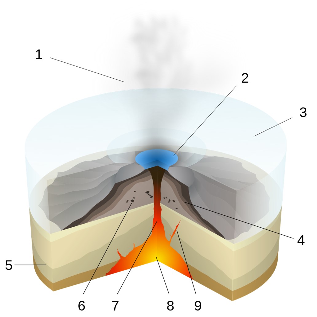
Scheme of a subglacial eruption: 1. Water vapor cloud; 2. Lake; 3. Ice; 4. Lava and hyaloclastites; 5. Preexisting rock; 6. Pillow lava; 7. Magma conduit; 8. Magma chamber; 9. Dike
Credit: © Sémhur, via Wikimedia Commons - As the volcano melts its way through the ice, shards of the glass bubbles collect into distinctive mounds of hyaloclastites (“glass clasts”) that eventually build up into flat-topped mountains called “tuya,” capped by a horizontal lava flow once the magma reaches the top of the ice.
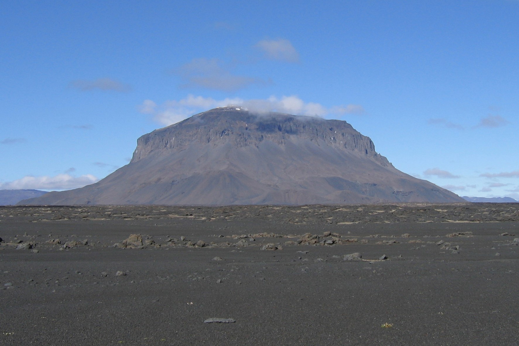
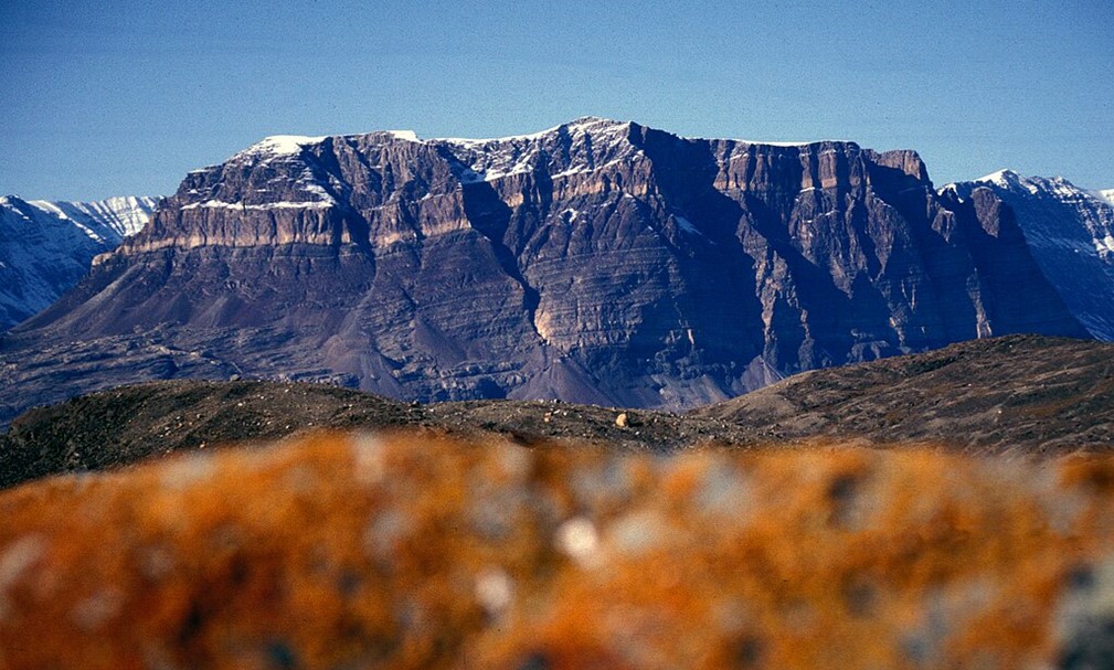
The mountain Herðubreið is a tuya formed as a volcano melted its way through a Pleistocene ice sheet, producing a steep-sided and flat-topped butte. It is part of Vatnajökull National Park in the interior of Iceland.
Credit: Icemuon, cropped by Seattle Skier, via Wikimedia Commons - As the eruption reaches the surface, ejecta may blanket the ice surface, while microscopic crystals of shattered volcanic glass may become airborne within a volcanic plume, a dangerous situation for aircraft engines. The eruption of Iceland’s Eyjafjallajökull shut down European airspace in April and May 2010, stranding passengers globally.
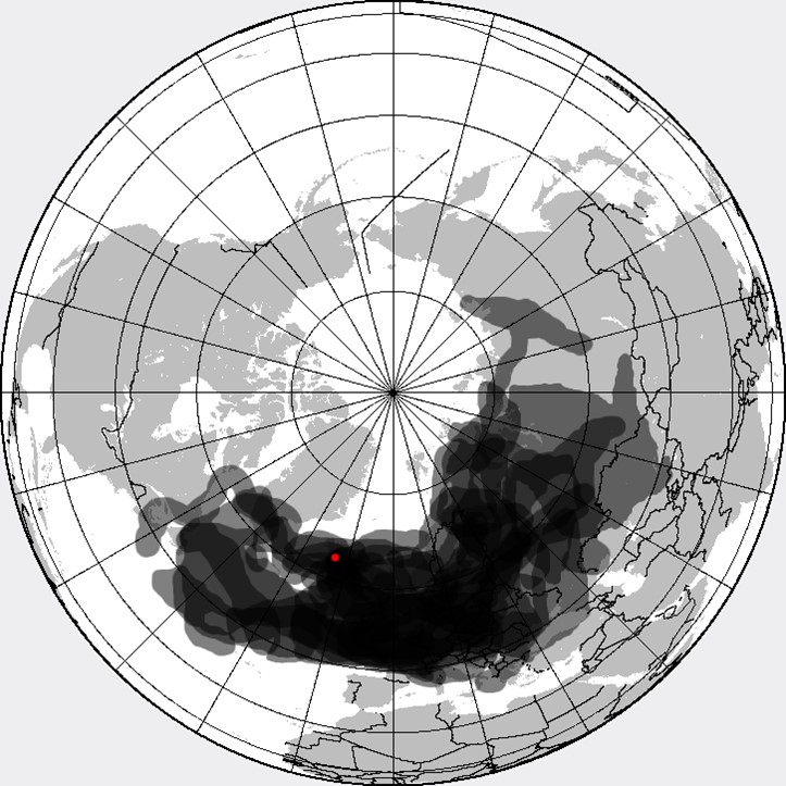
This composite map shows the daily position of the Icelandic volcanic ash cloud from Eyjafjallajökull (red dot) from April 14 through 25, 2010. Further disruptions occurred into May.
Credit: Cogiati, via Wikimedia Commons - The juxtaposition of heat and ice leads to an additional hazard from jökulhlaups—catastrophic glacial meltwater lake outburst floods in volcanic regions. They are difficult to predict because the ice dams that contain them are concealed beneath the ice and may be breached by either melting or earthquakes.
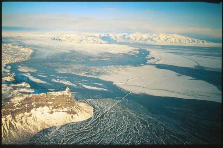
Iceland’s 1996 Gjálp subglacial-fissure eruption under 1,640 to 1,970 ft (500–600 m) of ice created a glacial outburst flood called a jökulhlaup when an ice dam broke, releasing the contents of a glacial lake into a glacial valley.
Credit: Laurentius Mirabilia, via Wikimedia Commons - Lava flows may follow preexisting ice tunnels or create an ice-marginal lava flow where the lava meets the glacier wall. The lava creates a depression in the ice then continues to fill it in as the base of the flow melts deeper and deeper into the glacier wall, leaving behind a tall, blunt “lava dam” after the ice melts.
- In this environment, ice and water quench lava instantaneously, producing volcanic glass bubbles.
- Some observers have speculated that volcanic activity in places like Greenland and Antarctica could be contributing to the documented recent increase in the rate of polar ice sheet melting, but the fact is that this volcanism is nothing new—it has been ongoing for millions of years.
- Greenland is made of uplifted layered oceanic basalts formed at a midocean spreading ridge and is thought to have traversed the mantle plume that currently underlies Iceland, but it doesn’t have any known active volcanoes today.
Layered basalts form Teufelsschloß (“Devil’s Castle”) in Franz Josef Fjord, East Greenland, are not volcanic, having formed at a spreading ridge.
Credit: Hannes Grobe 20:21, 16 December 2007 (UTC), via Wikimedia Commons - Remote sensing provides evidence of another mantle hot spot under western Antarctica’s Marie Byrd Land, where as many as 138 recently active subglacial volcanoes have created a vast network of lakes and rivers within the ice sheet over millions of years.
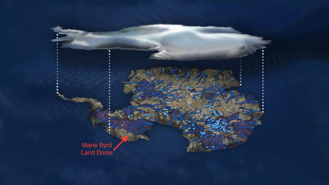
Illustration of flowing water under the Antarctic ice sheet. Surface of the ice sheet is white, blue dots indicate lakes and lines show rivers. Marie Byrd Land is part of the bulging "elbow" in the left center of the image.
Credit: NSF/Zina Deretsky - While none of these features have produced a recent dramatic surface eruption, mantle helium has been measured in meltwater flowing from the region.
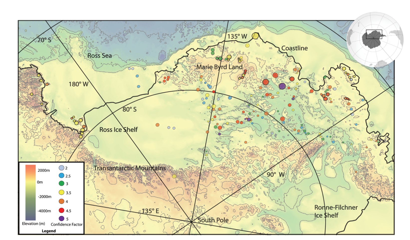
Map of the location of cone-shaped structures (circles) identified from the British Antarctic Survey's Bedmap2 ice thickness and subglacial topographic model of Antarctica (grayscale background) across the West Antarctic rift system. The color of the circles represents the degree of confidence the researchers have that the cones are subglacial volcanoes, and the circle size is proportional to the size of the cone’s base diameter. Circles with black rims generally have tips that protrude above the ice surface.
Credit: M. Van Wyk de Vries et al., 2018, CC BY 3.0, via the Geological Society of London.
- Greenland is made of uplifted layered oceanic basalts formed at a midocean spreading ridge and is thought to have traversed the mantle plume that currently underlies Iceland, but it doesn’t have any known active volcanoes today.
- Recent evidence from NASA's Mars Reconnaissance Orbiter, along with observations of Earth-based analogs, suggests Mars was home to subglacial volcanoes in the past.
- The topography of flat-topped mountains called Sisyphi Montes in a southern region of Mars resembles subglacial tuya buttes on Earth.
- The orbiter’s Compact Reconnaissance Imaging Spectrometer for Mars (CRISM) produces mineralogical data with a resolution of 60 ft (18 m). It detected the same minerals in the region as is found around Earthbound tuya: zeolites, iron oxides, sulfates and clays.
- Sisyphi Montes is 1,000 mi (1,600 km) from the southern polar ice cap of Mars, which is currently 220 mi (350 km) in diameter. If these features developed under ice sheets, Mars had much larger polar ice caps at that time.
- Researchers can use the observations of these types of features on Earth to estimate the thickness of the Martian ice caps that obscured the subglacial volcanic events that formed them.
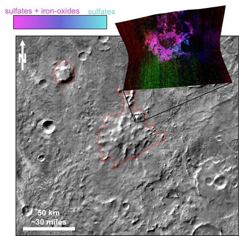
This graphic illustrates where Mars mineral-mapping from orbit has detected minerals (sulfates in blue and iron oxides in pink) that can indicate where a volcano erupted beneath an ice sheet. The site is far from any ice sheet on modern Mars, in an area where unusual shapes (like this one outlined in red) have been interpreted as a possible result of volcanism under ice.
Credits: NASA/JPL-Caltech/JHUAPL/ASU