Credit: Japan Meteorological Agency (picture of the day for 12/09/22), via Wikimedia Commons
In January 2022, the largest volcanic eruption since Mount Pinatubo happened. And few people noticed.
That’s because it occurred in the remote kingdom of Tonga, made up of tiny, sparsely inhabited islands in the South Pacific.
But that doesn’t mean it wasn’t important. It produced the highest eruption cloud in modern times, and changed the way scientists view the interaction between volcanoes and the atmosphere.
Here’s what happened: the volcano’s vent was 500 feet below sea level. As it erupted, the water column collapsed into it, where cool seawater met 2,000-degree-Fahrenheit magma and violently exploded into steam.
This caused a self-perpetuating explosion: the steam would blow out the rock, tunneling farther down into the volcano. This exposed more magma, which vaporized more water, and tunneled farther down.
By its end, the eruption had excavated 2,300 feet down, wiping out the entire volcano and two nearby uninhabited islands.
It also created a water vapor cloud 36 miles that punched upward, into the high atmosphere.
As the cloud cooled, it collapsed into the stratosphere, causing atmospheric shockwaves that circled the globe. These interacted with the ocean surface, forming fast-moving micro tsunamis, just a few inches tall, across the Pacific.
Scientists will be studying data from Tonga for decades to come, to better understand both future and past eruptions.
Background
Synopsis: In late 2021, a volcano in the South Pacific island nation of Tonga began to erupt, culminating in an enormous eruption a few weeks later on January 15, 2022. It was the largest atmospheric explosion since the eruption of Mount Pinatubo in 1991, providing scientists with unprecedented volumes of modern data. It produced an ash-laden water vapor plume that blew through the troposphere and stratosphere to pierce the mesosphere and created atmospheric waves that circled Earth several times, generating superfast tsunamis in addition to an unusually large oceanic tsunami. The caldera’s shallow water setting contributed to the power and unique characteristics of this memorable eruption.
- The Polynesian island nation of Tonga is an archipelago of 171 islands along a volcanic arc that is spread out over an area of the South Pacific larger than the state of Texas.
- The total land area of the volcanic islands is only about 1/1000th of that area.
- Tonga lies about 1,100 mi (1,800 km) northeast of New Zealand’s North Island. Fiji is to its west and Samoa is to its north.
- Tonga is home to around 100,000 people who live on just 45 of the islands, with 70% of the population residing on the main island of Tongatapu with its capital city of Nuku’alofa.
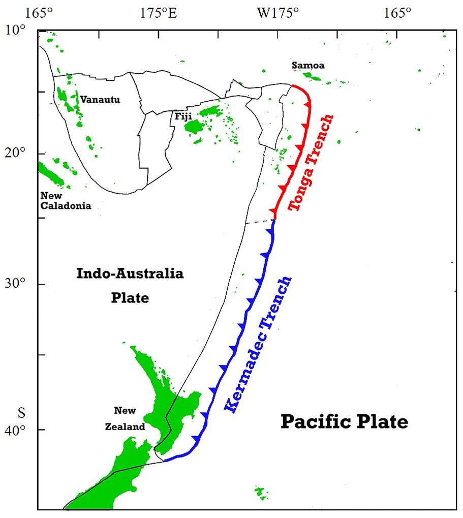
The kingdom of Tonga lies in the volcanic arc produced as the Pacific Plate slides below the Indo-Australian Plate along the Kermadec-Tonga subduction zone. The subduction rate along the Tonga Trench is one of the fastest on Earth at 9.5 inches a year (24 centimeters a year).
Credit: Nwbeeson, via Wikimedia Commons
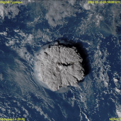
- On December 20, 2021, a volcano 40 mi (65 km) northwest of the main island of Tongatapu began to erupt, with explosions that could be heard 110 mi (170 km) away.
- The Hunga Tonga–Hunga Haʻapai volcano rises about 5,800 ft (1,800 m) above the seafloor and is roughly 62 mi (100 km) vertically above the westward dipping subduction zone.
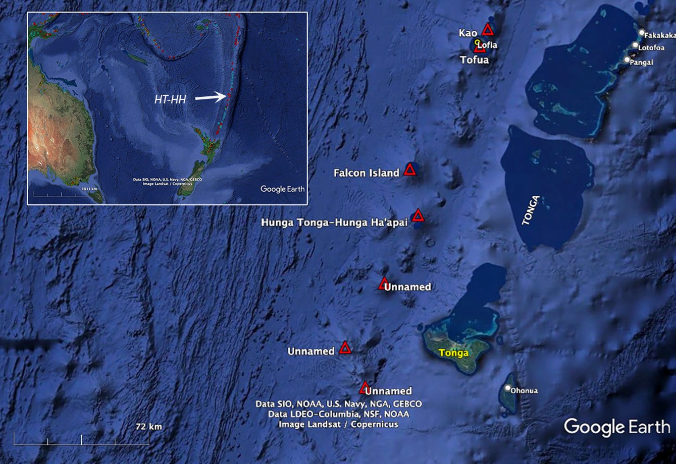
Hunga Tonga–Hunga Ha’apai volcano in the southwest Pacific is 40 miles (65 kilometers) northwest of the island of Tongatapu, where the capital of the Kingdom of Tonga, Nuku’alofa, is located. It lies 2,000 kilometers north of New Zealand and over 3,000 kilometers northeast of Australia. Several submarine volcanoes long the Tofua Arc are shown in red triangles. The Tonga-Kermadec trench lies to the east (right) of the islands in the volcanic arc. Courtesy of Google Earth.
Credit: Global Volcanism Program, Smithsonian Institution - Scientists had sampled older volcanic rocks called ignimbrites on the islands that had formed in more violent eruptions. These pyroclastic deposits were welded together along with charcoal that was dated at both AD 1100 and AD 200—indicating big eruptions had occurred at this volcano about 1,000 years apart.
- In 2015, the volcano had erupted to join the uninhabited islands of Hunga Tonga and Hunga Haʻapai together as the northern and western exposed rims of a caldera that was 2.5 mi (4 km) at its widest point and 490 ft (150 m) deep.
- The Hunga Tonga–Hunga Haʻapai volcano rises about 5,800 ft (1,800 m) above the seafloor and is roughly 62 mi (100 km) vertically above the westward dipping subduction zone.
- The volcano waxed and waned over the next few weeks; then, at 5:30 PM local time on January 15, 2022, it underwent a massive eruption that lasted 11 hours, blowing away most of the island.
- This eruption was heard 6,200 mi (10,000 km) away in Fairbanks, Alaska.
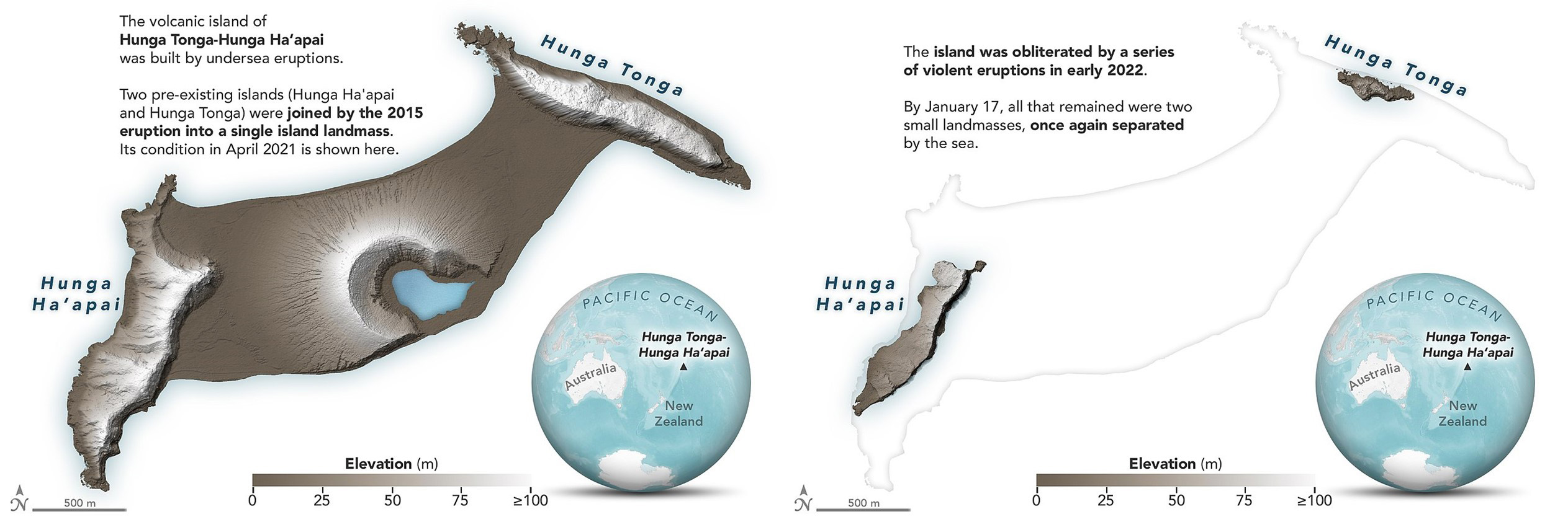
The recently united Tongan islands of Hunga Tonga and Hunga Haʻapai were joined together by an eruption in 2015 (left), then destroyed by powerful volcanic eruptions in mid-January 2022, leaving two small remnants separated by the sea (right).
Credit: NASA Earth Observatory, public domain, via Wikimedia Commons
- This eruption was heard 6,200 mi (10,000 km) away in Fairbanks, Alaska.
- The explosion was amplified because of the geological setting of the caldera.
- This type of volcanic eruption is called a Surtseyan eruption, after the Icelandic island of Surtsey, which formed in 1963 from an eruption in a caldera of similar water depth.
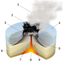
Surtseyan eruptions occur in shallow water, intensifying the energy of the underlying eruption: 1 water vapor cloud, 2 ash jet, 3 crater, 4 water, 5 layers of lava and ash, 6 sediments, 7 magma conduit, 8 magma chamber, and 9 dike.
Credit: Sémhur, via Wikimedia Commons - The weight of the 490 ft (150 m) of water in the Tongan caldera was not enough to suppress the volcanic explosion, however, once the eruption began, huge volumes of water repeatedly rushed into the active caldera at about 68°F (20°C), reacting explosively with the hot magma at 2,030°F (1,110°C), creating a constant crackling noise.
- Each successive hydromagmatic explosion excavated the caldera further. Recent surveys show that the new caldera floor is 2,800 ft (850 m) deep—2,300 ft (700 m) deeper than before.
- The explosions were so intense they shattered crystals erupting in the magma.
- The eruption was the largest since the 1991 eruption of Mount Pinatubo in the Philippines. Volcanologists rate it a VEI-5 based on an estimate of 2.5 mi2 (6.5 km2) of ejecta. Pinatubo (1991) and Krakatoa (1883) were VEI-6 and Tambora (1815) was VEI-8 (ED-013 The Year Without a Summer).
- This type of volcanic eruption is called a Surtseyan eruption, after the Icelandic island of Surtsey, which formed in 1963 from an eruption in a caldera of similar water depth.
- The remote location of the volcano minimized the human impact of the powerful blast, resulting in about US$90 million in damages.
- Many structures were wiped out on surrounding islands, ash covered buildings and crops, and communications were cut off as submarine cables were severed.
- Four deaths occurred in Tonga, with two tsunami drowning deaths in Peru.
- Modern technologies captured many remarkable details of the eruption, providing first-time specifics about the surprising global scale impact of volcanic events.
- The January 15 eruption released the equivalent of 61 million tons (Mt) of TNT (255 petajoules)—more than the world’s largest nuclear explosion in 1961 of Russia’s Tsar Bomba, which was estimated at 50 to 58 Mt of TNT.
- It blasted a huge cloud of water vapor 36 mi (58 km) through the troposphere and stratosphere all the way into Earth’s mesosphere.
- It produced more than 400,000 lightning strikes in just six hours, for a total of 590,000 strikes during the eruption, 75% more than the previous record from 2018 at Anak Krakatau.
- The plume increased the water vapor content of the stratosphere by 10%. While past eruptions produced plumes rich in ash and sulfur dioxide that cooled Earth by reflecting sunlight, the much higher proportion of water vapor delivered to the stratosphere by this plume may cause greenhouse warming and threaten the ozone layer. Scientists are still evaluating the situation. A small sulfur dioxide plume extended over Australia but probably only produced a bit of acid rain.
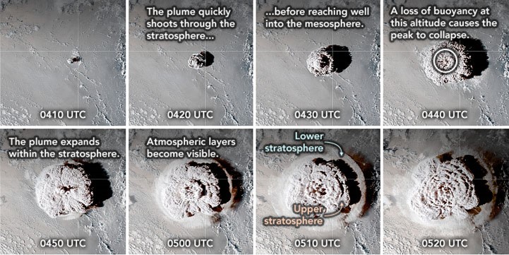
This sequence of still images from GOES-17 shows the plume at various stages on January 15, blasting into the mesosphere in just 30 minutes. Researchers used stereoscopic observations from two weather satellites (NASA’s GOES-17 and Japan’s Himawari-8) to create a 3D view of the clouds and determine the height of the plume at 36 miles (58 km), 1.5 times the previous record height of Pinatubo’s plume.
Credit: NASA Earth Observatory, public domain - As the volcanic plume collapsed from the mesosphere into the stratosphere, it spread outward into an umbrella larger than the U.S. state of Georgia (60,000 mi2 or 157,000 km2) in less than 30 minutes, creating atmospheric waves that could be seen circling Earth at about 1,000 ft (300 m) per second in opposing directions, lapping the globe several times each way.
- Researchers have determined that as fast-moving atmospheric shock waves encountered the ocean surface, they became coupled to the air–water interface as atmospheric gravity waves, generating synchronized super fast-moving tsunamis that arrived at locations 1.5 to 2.5 times faster than typical tsunamis travel. Many of these were just inches tall but were measurable. Similar tsunami waves and atmospheric pulses were recorded ahead of tsunami arrivals in 1883 when Krakatoa erupted but couldn’t be explained until now.
- Most ocean tsunamis are caused when earthquakes change the configuration of the ocean floor such that water is displaced, but 5% of tsunamis are caused by water displacements related to volcanoes like Hunga Tonga–Hunga Haʻapai. Scientists modeled the responses of ocean instruments around the globe and determined that the original displacement of water during this eruption may have been as much as 300 ft (90 m) high over an area 7.5 mi (12 km) in diameter, producing a larger, separate set of tsunamis that followed those driven by atmospheric gravity waves.
- The detailed monitoring of the Hunga Tonga–Hunga Haʻapai eruption opened the eyes of global scientists to the variety of global impacts possible during volcanic eruptions and will lead to new avenues of research as researchers contemplate the data for years to come.