
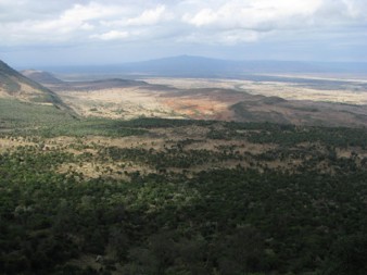
Credit: By shankar s. from Dubai, united arab emirates - Great Rift Valley, CC BY 2.0, https://commons.wikimedia.org/w/index.php?curid=69550626
Background
Synopsis: Deep beneath eastern Africa, tectonic forces are slowly pulling a continent apart. A surprising new discovery in the Turkana Rift suggests that this process may be unfolding in ways scientists did not expect, revealing new insights into the formation of rift valleys, ocean basins, and the landscapes that preserve our evolutionary history.
The East African Rift: A Continent Under Tension
- Deep beneath eastern Africa, forces within Earth’s mantle are helping pull a continent apart.
- Over millions of years, these forces have fractured the crust, created volcanoes and deep lakes, and produced one of the largest active rift systems on Earth.
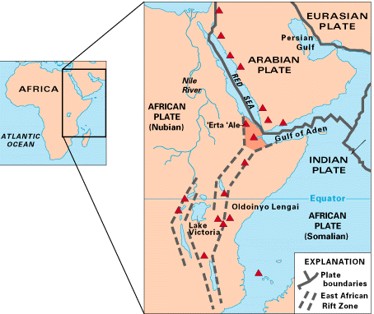
- The East African Rift stretches thousands of miles from the Afar region of Ethiopia southward through Kenya, Tanzania, and beyond.
- Rather than one continuous crack, it is a system of interconnected valleys and basins where tectonic forces are pulling the African continent apart.
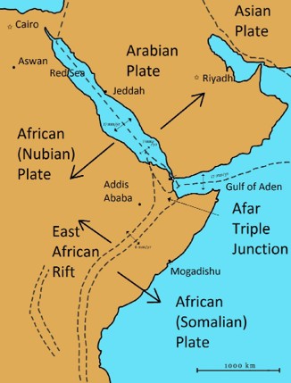
- The rift divides two major pieces of the African Plate:
- The Nubian Plate to the west
- The Somali Plate to the east.
- The rift system includes two main branches. The Eastern Rift runs though Ethiopia and Kenya, while the Western Rift contains some of Africa’s deepest lakes.
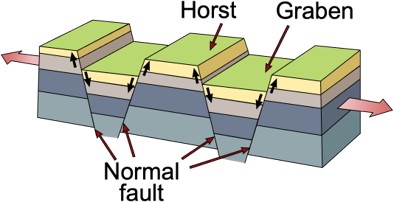
- As the crust stretches, sections break along what are called “normal” faults and sink, forming long troughs called grabens.
- In between the down dropped grabens are blocks of earth that are “uplifted” relative to the graben blocks. These are called “horsts.”
- The East African Rift is really a long chain of these horsts and grabens linked together across thousands of kilometers.
- An analogous geologic system exists in the Western United States called the Basin and Range, running north south across Nevada.
- Many of the region’s lakes, volcanoes, and valleys occupy these sunken blocks of crust, including the Turkana Rift, a broad basin that sits between the eastern and western branches of the rift system.
- Although the plates are moving apart by only a few millimeters per year, the cumulative effects of this stretching over millions of years have reshaped eastern Africa over millions of years.
- Movement of 2 mm a year over 1 million years is more than 1 mile of movement.
Credit: By USGS - http://pubs.usgs.gov/gip/dynamic/East_Africa.html, Public Domain, https://commons.wikimedia.org/w/index.php?curid=37695246
Lakes, Volcanoes, and Dramatic Landscapes
- Many of East Africa’s most striking features owe their existence to the rift.
- Some valleys created by the faulting filled with water forming long, deep lakes.
- Some of the world’s deepest lakes occupy rift valleys, including Lakes Tanganyika, Malawi, and Kivu.
- Lake Kivu was featured in another EarthDate episode.
- Many rift lakes are hundreds of meters deep because faulting causes the land to sink faster than sediment can fill it.
- Stretching along the crust also allows magma to rise more easily, fueling widespread volcanism.
- Active volcanoes such as Erta Ale, Nyiragongo, and Ol Doinyo Lengai are all connected to the rift system.
- The forces that helped build the Ethiopian Highlands and the landscapes explored in The Roof of Africa are linked to the same stretching process.
- The East African Rift is not simply a crack in the ground. It is an entire landscape shaped by tectonic forces.
Credit: By Horst_graben.jpg: U.S. Geological Surveyderivative work: Gregors (talk) 11:17, 7 June 2011 (UTC) - Horst_graben.jpg, Public Domain, https://commons.wikimedia.org/w/index.php?curid=15432947
The Traditional View: Afar Leads the Way
- For decades, geologists viewed the Afar region of Ethiopia as the most advanced stage of continental breakup in East Africa.
- This region sits near a tectonic triple junction where the Red Sea, Gulf of Aden, and the East African Rift meet.
- Active volcanism, frequent crustal stretching, and its connection to the Red Sea made Afar appear to be the part of the rift system closest to becoming a new ocean basin.
- Parts of the Afar Depression lie below sea level, giving the region an appearance unlike continental rifts and reinforcing the idea that it represents a later stage of breakup.
- For many scientists, Afar seemed the most likely place where continental rifting would eventually give way to seafloor spreading.
Credit: By Razashah1 - Own work, CC BY 3.0, https://commons.wikimedia.org/w/index.php?curid=12236875
A New Surprise from Turkana
- New research has revealed something unexpected.
- Scientists examined the crust beneath the Turkana Rift in northern Kenya and southern Ethiopia.
- Seismic wave data generated by earthquakes allowed researchers to create a picture of the crust deep below the rift.
- Changes in the speed of these waves revealed regions where the crust had become unusually thin.
- They found that parts of the crust are only about 13 kilometers (8 miles) thick.
- For comparison, continental crust is typically 30 to 50 kilometers (18.5 to 31 miles) thick, suggesting that the Turkana Rift has already undergone an extraordinary amount of stretching.
- In some areas of the Afar Depression, the crust has thinned to roughly 15-20 kilometers (9.3 to 12.4 miles), making the Turkana measurements unexpectedly similar to those found in one of the most mature parts of the rift system.
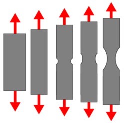
- This suggests that Turkana may have entered a stage known as “necking,” where continental crust begins to stretch and narrow dramatically before breaking apart.
- In other words, one of the most advanced sections of the rift may not be where scientists thought.
Credit: By Dtmrnav - Own work, CC BY-SA 4.0, https://commons.wikimedia.org/w/index.php?curid=79163355
A “Critical Threshold”
- One geophysicist involved in the research stated that this discovery shows that “we’ve reached a critical threshold of crustal breakdown.”
- But critical, in relation to geologic time scales, is relative.
- The discovery does not mean Africa will suddenly split in two, but the process will continue over millions of years.
- But it does change scientists’ understanding of how continental breakup occurs.
- Once necking begins, deformation often becomes concentrated into narrower zones.
- Over time, this focused stretching can lead to the formation of new oceanic crust.
- Rather than progressing steadily from north to south, different regions of the rift system may evolve at different rates. Some regions may thin rapidly while others lag behind.
- Scientists are still debating how quickly this transition occurs and whether all parts of the East African Rift will follow the same path.
- The formation of a future ocean may be more complicated than previously thought.
The Rift and Human Origins
- The Turkana region is famous for another reason.
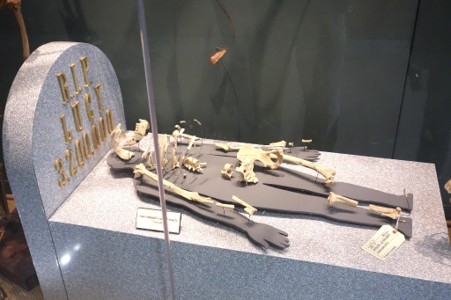
- Together with the neighboring Omo Valley in Ethiopia, the Omo-Turkana Basin contains one of the world’s richest collections of hominin fossils.
- More than 1,200 hominin fossil specimens have been recovered from the basin, representing an estimated 650 individuals and documenting nearly four million years of human evolution.
- Fossils from the basin represent several hominin species, providing an unusually detailed record of how different branches of human family appeared, overlapped in time, and changed over nearly four million years.
- As the crust thinned and the rift floor gradually sank, broad basins filled with layers of fine sediment.
- These sediments preserved the remains of ancient organisms, creating one of the richest fossil records of human evolution.
- The abundance of fossils has made Turkana one of the most important regions for studying human evolution. However, scientists continue to debate how representative the area is of the broader landscapes where early humans lived.
- The region may not have been uniquely important to evolution itself, but its geology made it exceptionally good at preserving evidence of the past.
Credit: By Daderot - Own work, CC0, https://commons.wikimedia.org/w/index.php?curid=37559706
The Next Ocean?
- The East African Rift offers a rare glimpse of continental breakup while it is happening.
- If rifting continues, eastern Africa could eventually separate from the rest of the continent, and a new ocean basin could form.
- Over millions of years, continued stretching could allow new oceanic crust to develop between the separating landmasses.
- The new findings from Turkana suggest that this transition may not unfold exactly where scientists once expected.
Episode Script
On the shores of Lake Turkana, in Kenya, archaeologists have uncovered the largest concentration of hominin fossils discovered to date.
They include the remains of 600 individuals, from several species of pre-humans, going back 4 million years.
Was the lakeshore a hotbed for our ancient ancestors? Or was it simply the best place in Africa to preserve their fossils?
Turkana lies on the East African Rift, a plate boundary fault system where the continent is pulling apart -- very slowly.
The rift fault system has created a chain of alternating lowland valleys and highlands stretching almost four thousand miles from Ethiopia through Kenya, Tanzania and southward.
Over thousands of centuries, the lowlands of the Turkana basin flooded many times, washing in sediment, mud, and ash from the area’s volcanos.
The sediment quickly covered the remains – of pre-humans and other creatures – protecting them from weather, scavengers and decay.
Indeed, the lowlands of the Rift Valley – also home to Tanzania’s Olduvai Gorge, famous for its hominin fossils – are an archaeologist’s nirvana.
But the Rift Valley, with its abundant water and vegetation, could also have been the cradle of humankind.
And one day, it will all be a shallow ocean, when the rift finally gives way and the sea washes in.
But that may take another 4 million years. Plenty of time for more fossil discoveries.