At the bottom of one of Africa’s deepest lakes lies a secret that could put two million nearby residents in danger.
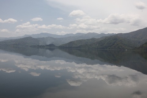
Lake Kivu sits along the East African Rift Valley, where the tectonic plates that bisect Africa pull apart.
Volcanoes leak natural carbon dioxide into the bottom of the lake, where the water pressure is high enough to dissolve and concentrate the gas in water.
If the water temperature changes, or the water column is overturned, the CO2 can suddenly turn to gas again and shoot to the surface.
One such event happened in Cameroon’s Lake Nyos, erupting 300 feet in the air and causing a tsunami that swamped lakeside villages. A concentrated CO2 cloud filled the lowlands around the lake, displacing oxygen and killings thousands of livestock and people.
In Lake Kivu, bacteria process the CO2 into methane, meaning there are huge volumes of both gases—2,000 times greater than in Lake Nyos.
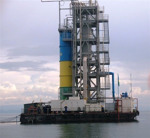
To keep them from erupting in a potentially larger and more deadly event, scientists now pump the lake’s deep waters to the surface, where the methane evolves out.
It’s piped to shore and used as cooking fuel in place of wood to prevent deforestation and local air pollution and to make electricity for local communities.
The CO2 is pumped back to the bottom of the lake where it’s stored and monitored.
In this way, science and technology have turned Kivu’s gases into a beneficial energy resource.
Background
Synopsis: Lake Kivu, which lies within a rift valley along the East African Rift System, is unusually well stratified with bottom waters that are enriched in naturally dissolved carbon dioxide and methane lying below a cold layer of surface water. If the delicate balance that keeps these heavier than air gases sequestered is disrupted, explosions and suffocating gas clouds could sweep through the valley’s population of millions. Engineering efforts are underway to gradually reduce methane concentrations by producing the gas for local power generation.
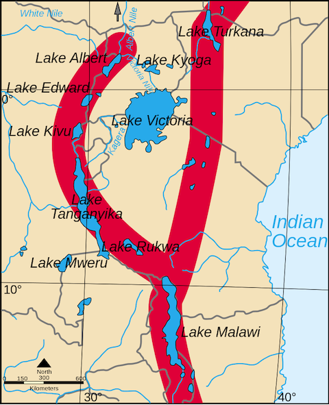
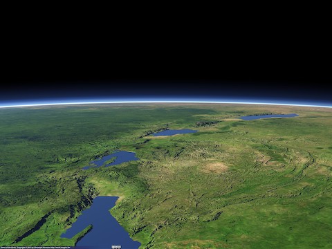
- Africa is splitting apart along the East African Rift System, marked by dramatic rift valleys and mountain ranges.
- The East African Rift System is a divergent rift system that started breaking Africa apart around 22–25 million years ago in the early Miocene Epoch.
- The Nubian Plate to the west includes most of Africa, while the Somali Plate includes East Africa and a portion of the Indian Ocean.
- The rift splits into a western rift valley and an eastern rift valley that encircle the Victoria Microplate, which is rotating counterclockwise.
- Rotation of the Victoria Microplate along the western limb of the rift system has produced a series of lakes and mountain ranges.
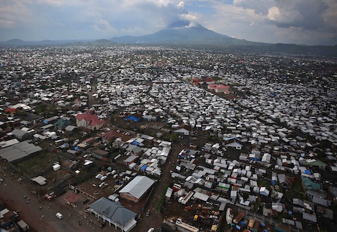
- Lake Kivu and the Virunga Mountains form the boundary between the Democratic Republic of the Congo and Rwanda. The region has a population of about two million.
- At the north end of the lake, the twin cities of Goma, DRC and Gisenyi, Rwanda are home to more than 750,000 residents.
- At the south end of the lake, nearly 900,000 people live in Bukavu.
- Lake Kivu is an irregularly shaped lake that is roughly 31 mi (50 km) across and 56 mi (90 km) long, making it Africa’s eighth largest lake.
- The lake’s surface is at 4,790 ft (1,460 m) elevation with depths of more than 1,500 ft (460 m).
- It’s mean depth of 722 ft (220 m) makes it Earth’s ninth deepest lake.
- The Virunga Mountains, known locally as Mufumbiro, is volcanic chain with six dormant volcanoes and two active volcanoes.
- Mount Nyiragongo at 11,358 ft (3,462 m) is an active stratovolcano about 7.5 mi (12 km) north of Goma that most recently erupted in May 2021.
- Mount Nyamuragira at 10,049 ft (3,063 m) is an active shield volcano about 16 mi (25 km) north of Goma that last erupted in 2011.
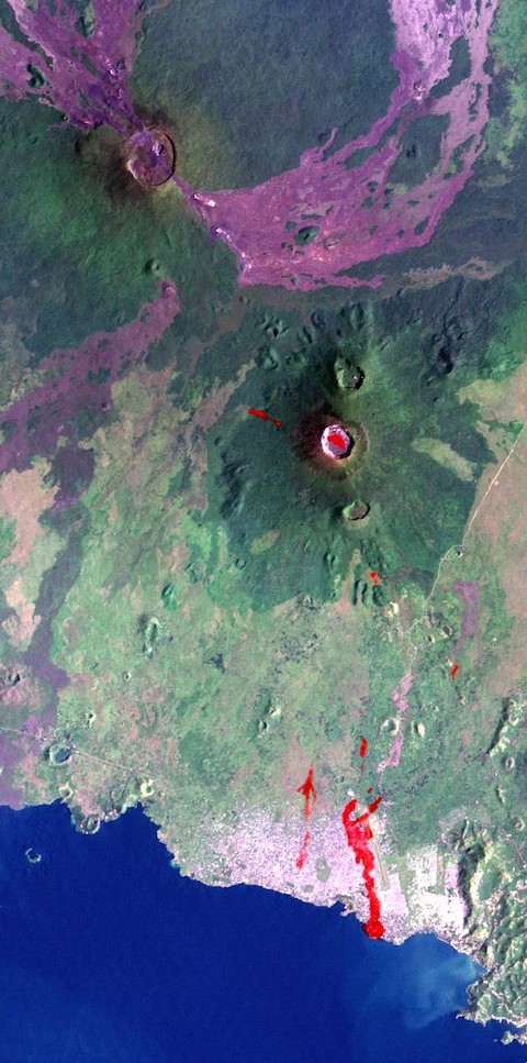
- This active volcanic system leaks gases that dissolve in the high pressure of Lake Kivu’s very deep bottom waters.
- Only three African lakes are known to hold dissolved gases pressurized in their bottom waters.
- In the mid-1980s, the other two, Lake Monoun and Lake Nyos, both located near a different volcanic field in Cameroon, experienced catastrophic lake overturns that depressurized the water, causing dissolved gases to come out of solution and release suddenly.
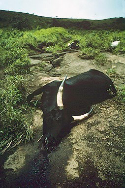
- During the 1986 event at Lake Nyos (NEE-ohs), naturally formed carbon dioxide shot 300 ft (100 m) upward, displacing so much water that tsunamis swamped lakeside villages that were home to a population of around 14,000.
- Immediately afterward, clouds of heavier-than-air CO2 (known locally as mazuku) collapsed downward, filling low-lying areas around the lakes, displacing oxygen, and suffocating nearly 1,800 people and thousands of livestock.
- Lake Kivu’s volume is 2,000 times that of Lake Nyos, and the lake is strongly stratified with warmer bottom waters enriched in concentrated carbon dioxide and methane, sequestered below a layer of about 200 ft (60 m) of colder surface waters.
- Microbes in Lake Kivu consume some carbon dioxide, producing methane as a byproduct, and both gases remain dissolved in the water because of the high pressure of the lake’s great depths.
- The surface waters of most lakes cool as seasonal temperatures fall each year, causing the colder, denser water to sink, overturning and mixing the lake water.
- Carbon dioxide and methane gases, along with trapped sediments and the products of hydrothermal springs, make the bottom waters of Lake Kivu dense enough to inhibit annual turnover.
- Researchers are concerned that if the delicate balance in the lake is upset many cubic miles of gas could be released, creating a disastrous, methane-charged limnic eruption.
- Evidence of previous limnic eruptions can be seen on lake bottom sediment cores as unusual brown organic rich layers.
- One distinctive event appears to have occurred between 3,500 and 5,000 years ago when drought caused the upper layer of lake water to evaporate to the point that pressures deep in the lake dropped, releasing the dissolved gases.
- Extreme rain events with flooding could also trigger lake mixing, especially if the upper layer is already compromised and thinned by drought.
- The lake is in a seismically and volcanically active area, so earthquakes and volcanic eruptions are additional concerns.
- The lake is monitored for gas concentration seismic activity.
- The good news is that Kivu’s dangerous methane has now become a renewable resource for the region.
- In the thirty years from 1974 to 2004, the natural carbon dioxide levels in Lake Kivu rose 10%, but the methane levels rose 15–20%.
- Projects are underway to circulate the lake’s bottom waters to the surface, evolving methane to power the region, which suffers from poor air quality because most of the population must use wood burning stoves.
- The methane is transported by pipeline onshore to be used as fuel, gradually reducing the volume of flammable gas in the lake.
- Carbon dioxide is pumped gently back into the depths and monitored carefully.
- Rwanda’s KivuWatt Project will produce 100 megawatts of power for the region.