Credit: © Sergey Pesterev, via Wikimedia Commons
Ernest Hemingway made Mount Kilimanjaro famous with his story “The Snows of Kilimanjaro”—though he never climbed the peak.
But many others have. More than 30,000 try each year, with two-thirds reaching the top.
Kili, as it’s called, is the tallest mountain in Africa but the easiest climb of the Seven Summits—the highest peaks on the seven continents.
Its high camps have hosted some world record sporting events, including the highest professional soccer game, with players hailing from 20 countries.
It’s a unique ascent, traversing five different ecological zones, from cultivated lands to rain forest, then moorland, alpine desert and finally an arctic summit.
The summit of Mount Kilimanjaro is actually three volcanic cones. The last major eruption ended 170,000 years ago, and all peaks are thought to be either extinct or dormant.
There are glaciers in the highest areas, but they’re disappearing quickly, down more than 80 percent since the early 1900’s. It’s thought this is mostly related to human deforestation in the valleys surrounding the mountain, disrupting its microclimate.
The valleys have fertile volcanic soils and ample rainfall, producing the tallest trees in Africa. Tanzania has recently pushed to protect them from logging and is now replanting millions of indigenous trees in an effort to reforest the area.
Through careful stewardship, the mountain could be protected from the further impacts of humans.
Background
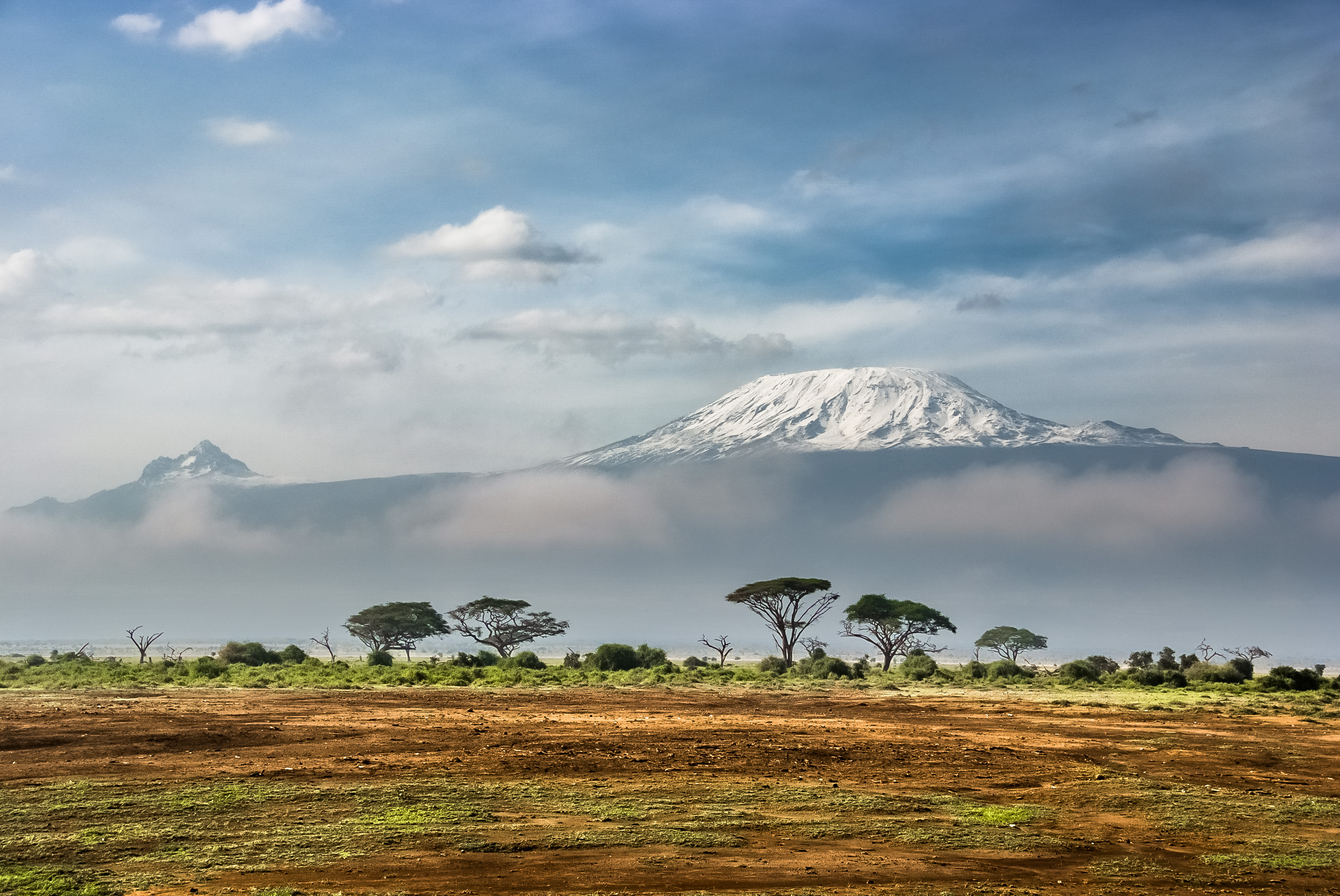
Synopsis: Africa’s tallest mountain, Kilimanjaro, is just south of the equator in the East African Rift Valley. Despite its latitude, it has glaciers and arctic ecosystems at its summit.
- Mount Kilimanjaro is the tallest mountain in Africa, making it one of the Seven Summits, the highest mountains on each of Earth’s seven continents.
- Climbing to the highest point on all seven continents is a goal for many climbing enthusiasts. These peaks include:
- Asia: Everest (29,035 ft/8,848 m)
- South America: Aconcagua (22,834 ft/6,962 m)
- North America: Denali (20,310 ft/6,194 m)
- Africa: Kilimanjaro (19,340 ft/5,892 m)
- Europe: Elbrus (18,513 ft/5,642 m)
- Antarctica: Vinson Massif (16,050 ft/4,892 m)
- Australia: Kosciuszko (7,310 ft/2,228 m)
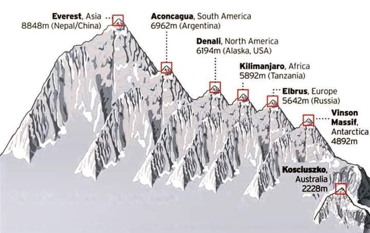
The Seven Summits are shown on this diagram in order of decreasing height. Climbing to the summit of all seven was first done on April 30, 1985, by Richard Bass.
Credit: Retrieved from https://www.caingram.info/Seven_summits.htm
- About 25,000 people attempt the Kilimanjaro climb every year, and about two-thirds make it to the top. At 3.66 mi (5.89 km) above sea level, altitude issues cause many to turn back.
- It is considered to be the easiest of the Seven Summits because it doesn’t require special equipment; it is a hike-up summit, not a climb-up summit.
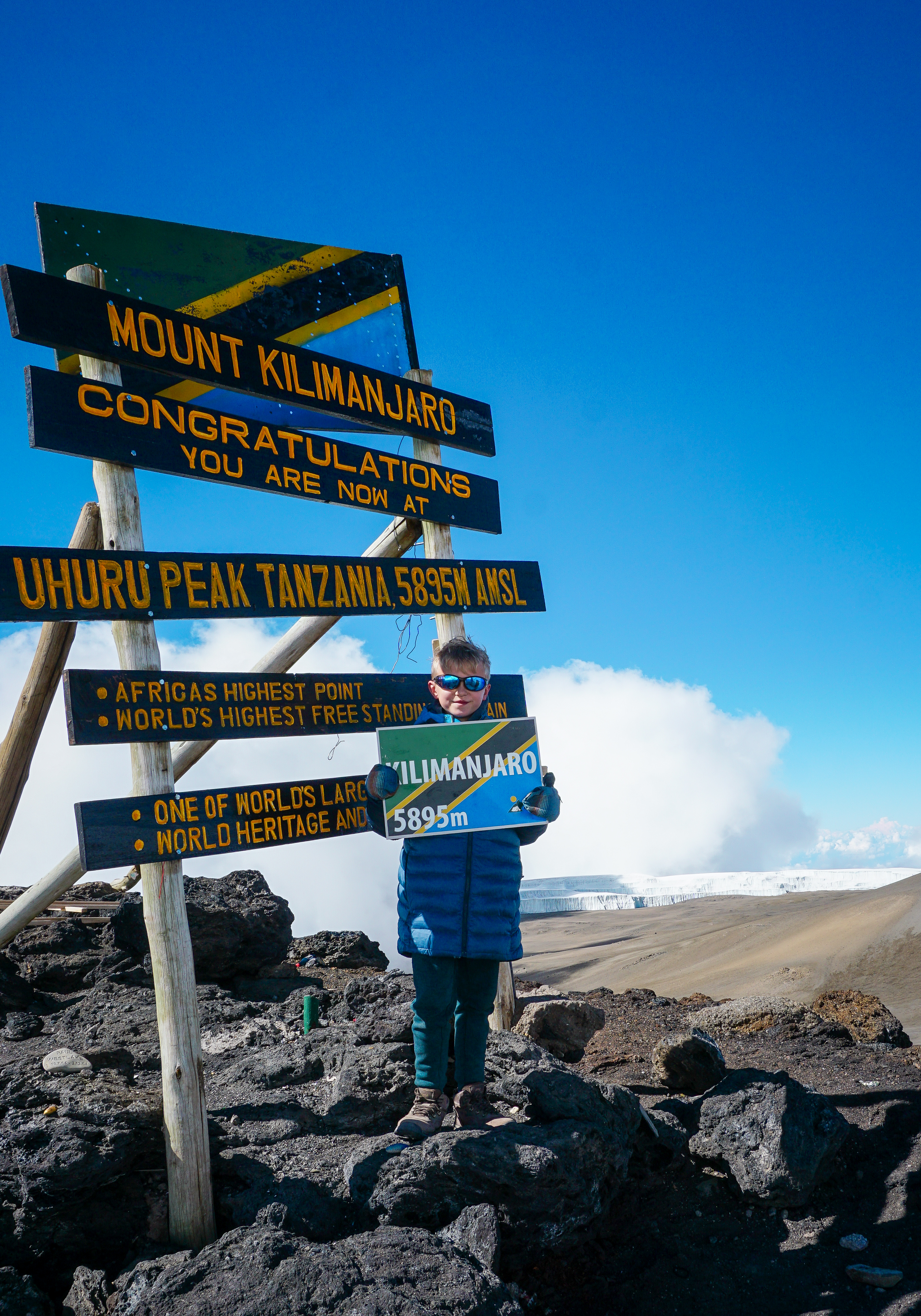
A young hiker displays the Tanzanian flag at the summit of Mt. Kilimanjaro (Tanzania, Africa) in December 2020.
Credit: Kbarkerthefirst, via Wikimedia Commons
- Climbing to the highest point on all seven continents is a goal for many climbing enthusiasts. These peaks include:
- Geologically speaking, Mount Kilimanjaro is located along the eastern flank of the East African Rift Valley.
- Active continental rifting began in eastern Africa around 22 to 25 million years ago in the Miocene Epoch, the result of a mantle plume “hot spot” that stretched and cracked the brittle lithosphere into a Y-shaped rift system accompanied by flood basalts.
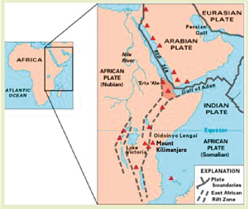
Map of East Africa showing some of the historically active volcanoes (red triangles) and the Afar Triangle (shaded, center). Mount Kilimanjaro lies about 200 kilometers south of the equator along the eastern flank of the East African Rift Valley in Tanzania near its border with Kenya.
Credit: USGS, public domain, via Wikimedia Commons - The Afar Triangle is a triple junction boundary where the Arabian, Nubian and Somalian Plates are pulling away from each other.
- Farther south, the eastern and western flanks of the rift valley encircle the much smaller Victoria Microplate. Mount Kilimanjaro lies at the edge of the Somalian Plate where it is rifting away from the Victoria Microplate.
- This early rift system has been compared to the initial stages of North Atlantic rifting that occurred 60 to 55 million years ago, producing today’s Atlantic Ocean.
- Active continental rifting began in eastern Africa around 22 to 25 million years ago in the Miocene Epoch, the result of a mantle plume “hot spot” that stretched and cracked the brittle lithosphere into a Y-shaped rift system accompanied by flood basalts.
- Mount Kilimanjaro extends 16,100 ft (4,900 m) above the surrounding plateau and is a stratovolcano composed of three volcanic cones: Shira (13,000 ft/3,962 m), Mawenzi (16,893 ft/5,149 m), and Kibo (19,340 ft/5,892 m).
- Low viscosity lava flows came first, creating a gently sloping base about 2.5 million years ago.
- Then more viscous lava flows and ash created the Shira volcanic cone, which collapsed to create a caldera depression surrounded by what is now known as the Shira Ridge.
- About a million years ago, two more major volcanic cones, Mawenzi and Kibo, formed. Like Shira, Mawenzi is now extinct, but Kibo is dormant and could erupt again.
- Kibo’s highest peak, Uhuru, is the highest point in Africa, the ultimate destination of seven summit climbers.
- The last major Kibo eruption ended 170,000 years ago, but fumaroles continue to emit gas in Kibo’s crater.
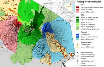
Simplified geological map of the three volcanic centers of Mount Kilimanjaro, Tanzania. Lavas from Shira are red, Mawenzi are blue and Kibo are green.
Credit: Sémhur (derivative work), via Wikimedia Commons
- The mountain is just 205 mi (330 km) south of the equator, so the slopes of Mount Kilimanjaro have climatic zones that range from its lower slopes that are covered with typical bushland, to rainforest and heather-covered moorland, to alpine desert, and to an arctic zone, complete with imposing glaciers, near its precipice.
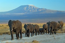
Elephants at Amboseli National Park, Kenya, in August 2012 with Mount Kilimanjaro in the background.
Credit: Amoghavarsha JS amoghavarsha.com, via Wikimedia Commons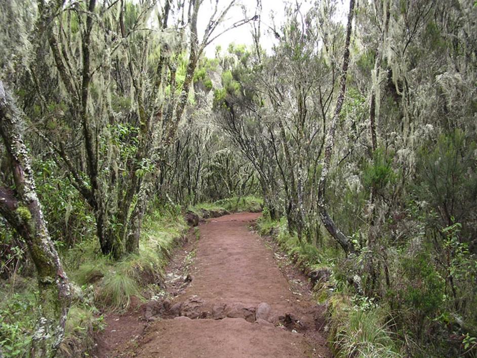
A cloud forest in the rain forest zone along the Marangu climbing route on Kilimanjaro’s southeastern slope.
Credit: Yosemite, via Wikimedia Commons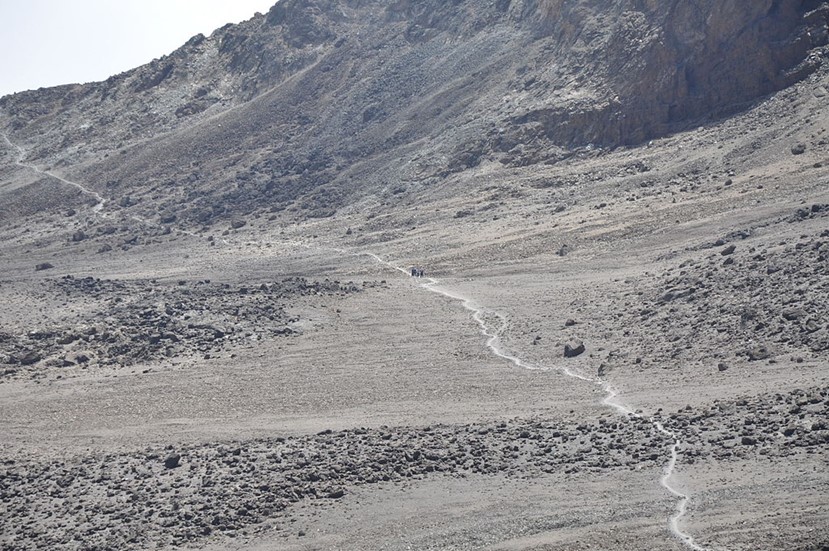
A higher elevation trail runs across a dry alpine desert of Mount Kilimanjaro.
Credit: Jorge Láscar from Australia, via Wikimedia Commons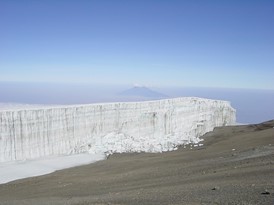
The Rebmann Glacier is located in the arctic zone of Kilimanjaro’s Southern Icefield on the way to the summit.
Credit: ProfessorX, via Wikimedia Commons - While snow may fall near Kilimanjaro’s summit anytime during the year, it tends to occur most frequently during two rainy seasons, with annual accumulations of 10 to 20 in (25–50 cm) during the year.
- But this is not enough snow to maintain its iconic glaciers, which have lost more than 80% of their mass since they were first mapped in 1912.
- Some projections suggest they could vanish by 2033.
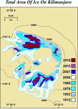
Kilimanjaro glacial retreat 1912 to 2018.
Credit: Tequila Kiev, via Wikimedia Commons
- The Tanzanian government created a national park around Kilimanjaro in 1973, and the UN declared the mountain to be a UNESCO World Heritage Site in 1987.
- In 1936, Ernest Hemmingway added to the mountain’s fame with his short story “The Snows of Kilimanjaro,” published in Esquire magazine.
- The story starts with these lines: “Close to the western summit there is the dried and frozen carcass of a leopard. No one has explained what the leopard was seeking at that altitude.”
- The 18,500 ft (5,638 m) point where the leopard was found by climber Richard Reusch in 1926 is called Leopard Point.
- Hemmingway never climbed Kilimanjaro, but he did view it from the base while on safari in 1933.
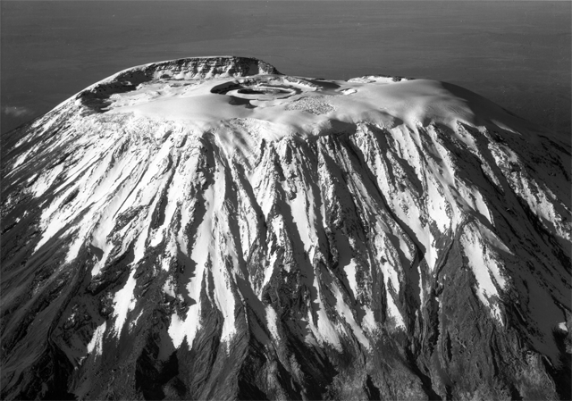
On January 15, 1938, Mt. Kilimanjaro’s snow-capped summit containing its nearly perfect crater is flanked by deep furrows of lava flow and glacial erosion.
Credit: Meader, Mary, 1916-2008, via Wikimedia Commons