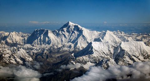
The world’s tallest mountain just had a couple of feet added to it.
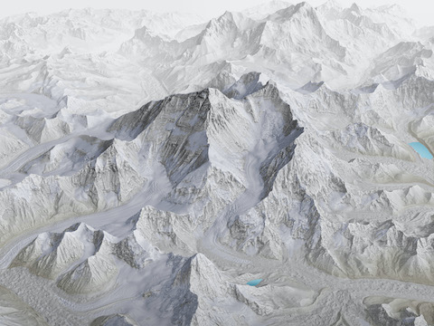
Mount Everest sits on the Nepal–Tibet border. In Nepalese, it’s called Sagarmatha, meaning “the head of the sky.” In Tibetan, it’s called Chomolungma, “goddess earth mother.”
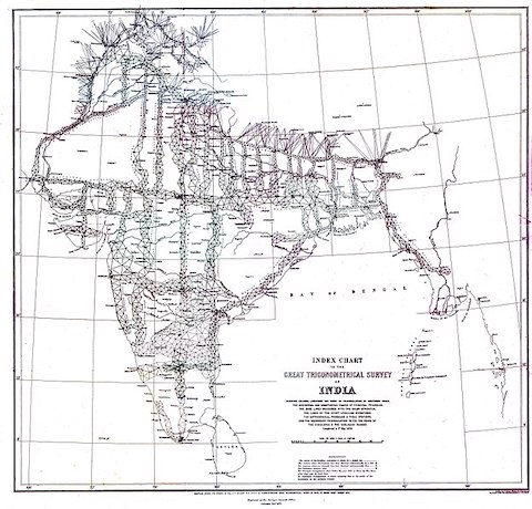
It got its English name to honor George Everest, who led the survey to map and measure the peaks of India and Nepal in the mid-1800s.
His team used triangulation to sight from point to point, thousands of times, to work out elevations. In 1856, they determined the height of Everest to be 29,003 feet.
That height stuck for a century, until an English-Nepali team finally climbed the mountain, and the survey increased its height to 29,029.
In 1999, the National Geographic Society used a GPS receiver to measure a slightly higher height of 29,035 feet.
But Nepal rejected this new technology and decided to survey it themselves, combining old and new methods.
In 2017, Nepalese climbers placed their own GPS receiver on the summit, then also triangulated its height using laser-guided telescopes from 12 other mountain tops. And China did the same from the Tibetan side.
Then, in a rare collaboration between the countries, they shared their data to arrive at a higher official height for Sagarmatha/Chomolungma: 29,031.69 feet. And that last foot is a doozy!
Background
Synopsis: Earth’s tallest mountain—Mount Everest—got almost 3 ft taller in December 2020. Nepalese and Chinese surveying teams each remeasured the mountain, then collaborated to update the elevation to 29,031.69 ft (8,848.86 m), which is 2.82 ft (0.86 m) taller than the previously accepted elevation. Although tectonic forces gradually increase the mountain’s height, erosion constantly wears it down and occasional earthquakes jolt the region.
- Earth has only 14 mountain peaks taller than 8,000 meters (26,247 ft), and Mount Everest is the tallest of these.
- The mountain lies mainly in Nepal along its border with Tibet.
- Its Nepalese name is Sagarmatha, which means “Forehead of the Sky”.
- Its Tibetan name is Chomolungma, which means “Mother Goddess of the World.”
- The first survey of the mountain occurred as part of the “Great Trigonometrical Survey” which measured the whole Indian subcontinent from 1802 to 1871.
- The survey was initiated by the East India Company, then shifted to the Survey of India, where George Everest oversaw the construction of a continuous meridian arc of 1500 mi (2400 km) from the southern tip of India to northern Nepal from 1823 to 1843.
- The Great Trigonometrical Survey used trigonometric calculations, triangulating from point to point thousands of times to work out the elevation of the subcontinent’s key landmarks.
- In 1856, the Survey finally determined the height of the peak to be 8840 m (29,002.62 ft). In 1865, the Royal Geographical Society gave the peak its English name to honor Everest.
- The 1856 elevation held for nearly a century. In 1955, after the first ascent of the summit in May 1953 by Sir Edmund Hillary and Tenzing Norgay, the Survey of India adjusted the height by 8 m (26.24 ft). The elevation of 8848 m (29,028.87 ft) remained Mount Everest’s official height until 2020.
- In 1999, the National Geographic Society used GPS to calculate a height of 8850 m (29,035.43 ft), but Nepal rejected the use of the new methods and technology.
- A Chinese survey in 2005 estimated the height at 8844.43 m (29,017.16 ft), but Nepal did not accept this height. One possible reason for this was that Tibet measured rock height, while Nepal measured snowpack elevation.
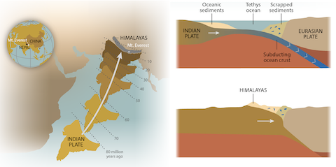
- Geological and tectonic forces impact the height of the Himalayas and Mount Everest.
- The Himalayas started forming 25–30 million years ago as plate tectonic forces drove India into Asia, crumpling both plates and forcing deep-sea sediments upward to the crest of the range.
- The Great Himalaya Range and Mount Everest started growing upward about 2.6 million years ago and are still growing today. Mount Everest is growing at about 10 cm (3.9 in) per century, while other parts of the range are uplifting as much as ten times faster—around 1 m (39.4 inches) per century.
- Erosion continually reduces the elevation of the range, ferrying vast quantities of sediments to the massive Ganges and Brahmaputra river deltas.
- Harsh weather conditions, glaciation, and frequent avalanches and landslides tear down the peaks.
- Earthquakes are another problem—they may increase or decrease elevation.
- In 1934, a magnitude 8.0 earthquake with an epicenter located 5.9 mi (9.5 km) south of Mount Everest is reported to have decreased the summit elevation by 63 cm (24.8 inches).
- A tectonic adjustment within the underlying plates caused a tragic magnitude 7.8 earthquake in April 2015 that killed almost 9000 people in Nepal and buried Everest’s base camp. Satellite data suggests nearby peaks in the Langtang Range saw height decreases of up to 1 m (3 ft), raising additional questions about the height of Everest’s summit after the quake.
- These competing geological forces tend to strike a balance, with constant growth being offset by erosion and sporadic earthquake adjustment of the peaks. Centuries of growth can be wiped out by a single major earthquake.
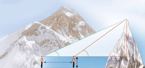
- How hard can it be to measure a 5.5-mi (8.8 km) tall mountain? There are three methods now in use, and the trickiest part can be working out where sea level intersects the base of the mountain.
- Trigonometry has been used for centuries, with surveyors using protractor-like telescopes called theodolites to measure angles in a web of successive triangles starting at the sea and working point to point until they are able to sight the location of interest.
- More recently GPS has been used, requiring a receiver to be placed at the location of interest and left there for an hour or longer as a satellite constellation makes repeated measurements, converting signal travel time to distance and elevation and referencing sea level.
- Photogrammetry is another method that requires aircraft to fly over a location of interest using 3D mapping techniques like LiDAR to create a grid of elevations that must be referenced back to sea level.
- All three refer to sea level, which is not level at all under the continents because of the gravitational pull of geological features like mountains. Earth’s geoid is an undulating surface that requires the use of gravimeters to work out the local gravity field before it can be used as a proxy for sea level.
- Additionally, at extreme elevations, the density of air is so low that light refraction must be corrected before angles can be correctly measured.

- With all the controversy regarding Everest’s elevation after the 2015 quake, the government of Nepal decided to build its own surveying capabilities and remeasure the mountain in 2017.
- To avoid other climbers and to reduce refraction, the Nepalese team reached Everest’s summit in the dead of night at 3:00 AM on May 22, 2019, to place their GPS beacon and take gravimeter readings to inform the calculations of the local geoid. They also used ground penetrating radar to measure the thickness of snow and ice atop the rocks on the peak.
- The Nepalese surveyors started at a point referenced to the Bay of Bengal and built a 250-km (155 mi) network of line-of-sight stations until they could sight and measure Everest’s peak from 12 nearby peaks using laser-equipped theodolites. These locations were also equipped with GPS receivers to cross-reference GPS elevations.
- In October 2019, Chinese president Xi Jinping visited Nepal’s capital Kathmandu and the countries agreed to collaborate on the final elevation calculation, calling the peak “an eternal symbol of the friendship between Nepal and China.”
- The Chinese team started building their triangulation network soon after the historic visit, using the Yellow Sea as their point of reference and ultimately using six lower peaks to triangulate to the top of Everest. They also placed receivers that communicated with the Chinese BeiDou navigation satellite constellation.
- In May 2020, the Chinese surveyors approached from the Tibetan side to place their BeiDou beacon on the peak and make other measurements. They had the mountain to themselves as the only group to summit Everest in 2020 because of pandemic travel restrictions in both Nepal and China.
- This robust data collection and unprecedented collaboration between Nepal and China continued, culminating in the December 8, 2020, joint announcement of a new official height for the peak: 29,031.69 ft (8,848.86 m), just 2.82 ft (0.86 m) taller than the previously accepted elevation.
- It is amazing that elevations calculated by hand in 1955 could be within 3 ft of measurements achieved with 2020 technology. The Survey of India did an extraordinary job 65 years ago!
- From this point forward, changes in elevation will be faster to document, helping scientists to better understand the trembling of the extraordinary mountain called Sagarmatha, Chomolungma, or Everest, depending on your place of origin.