On a previous EarthDate we talked about GPS, the Global Positioning System, and recent improvements that allow mapping down to the millimeter—accurate enough to detect the creeping movement of Earth’s tectonic plates.
These advances have inspired scientists to use GPS in many new ways to better understand earthquakes and other Earth processes.
The signals from GPS are very long—many thousands of digits—making them too slow to track seismic activity.
But recently, scientists realized they could use a different, much shorter part of the GPS signal and combine that with faster refreshing of GPS receivers.
This has allowed GPS to monitor earthquakes very accurately over a very broad area, enough to see their impact on distant communities.
And hopefully with new developments, fast enough to warn them of an impending quake.
Using similar technology, scientists can now measure and track other disruptions on Earth’s surface, such as sinkholes, landslides, and tidal waves.
Volcanic ash can disrupt GPS signals, so scientists devised a way to use those disruptions to monitor ash plumes and warn airplanes.
Similarly, water vapor in the atmosphere can delay GPS signals. Meteorologists are now reading that delay to predict heavy rainfall and advise communities about flash floods before they arrive.
All very interesting examples of how improvements in technology allow for advances in science.
Background
- In a previous EarthDate, we talked about the history of the U.S.-based Global Positioning System (GPS) and how it and other global navigation satellite systems can be used to track things from a person’s movement around town to the movement and deformation of Earth’s tectonic plates. GPS involves three segments.
- The space segment is the GPS Constellation that consists of a minimum of 24 operational satellites orbiting Earth once a day, such that four satellites can be seen at any given time in any given place.
- The control segment tracks and maintains the orbits of the satellites and operates ground-based stations.
- The user segment consists of the receiver equipment that we carry on our phones and in our cars. These receivers use GPS information to triangulate our 3D position within a few meters while also tracking the time we were at that position. Higher-quality scientific GPS receivers can track positions within centimeters or even millimeters.
- Receivers in our devices guide us to our destinations, while receivers attached to the ground tell us about tectonic movements over longer timeframes. GPS receivers have confirmed some tectonic plates move about as fast as our fingernails grow.
- Technological advances across these three segments have increased the precision and response time of GPS devices, inspiring the ingenuity of scientists charged with understanding dangerous Earth processes to come up with potentially life-saving applications for real-world hazards.
- Traditionally, geophysicists use seismometers to register ground shaking during earthquakes, relying on GPS to measure where the ground ended up after the event. The “code” transmitted from each GPS satellite is a unique series of zeroes and ones that may be tens to hundreds of meters long, rendering it fairly insensitive to quick motion.
- Ingenious scientists at the University of Colorado at Boulder realized that there is another signal that transmits the “code” from the satellite to the ground. Called the “carrier” signal, it is just 8 inches (20 cm) long. Scientists were able to figure out how to use it to create a more precise 3D result with just an upgraded receiver needed.
- Meanwhile, engineers have increased the rate at which GPS receivers refresh themselves to as much as 20 times per second, so time resolution has also improved.
- With these advances in location and time sensitivity, researchers are better equipped to observe earthquake motion from space.
- They have observed how the ground shifted in the western United States thousands of miles from the epicenter of an Alaskan earthquake, and they have documented a shift of 180 ft (60 m) on the seafloor during a 9.1-magnitude Japanese quake.
- Geophysicists are working on a way to tell the ultimate size of a quake in the first seconds of shaking. Using GPS and ground station data near the epicenters of 12 large past earthquakes, they were able to tell in 10 seconds if the quake would end up with 7-magnitude-level damage or the total devastation of a 9-magnitude temblor.
- The next step is using GPS to augment Earthquake Early Warning systems, giving citizens extra minutes of warning that could save their lives. Apps like the USGS’s ShakeAlert and Mexico’s Grillo are now available to residents in some seismically active regions.
- GPS helps with more hazards than just earthquakes. GPS signals provide a record of land subsidence, landslides, and avalanches and can provide advance warning of tsunamis.
- GPS reveals land subsidence from groundwater withdrawal and surface failure caused by sinkhole development.
- Just like GPS can record rapid motion during earthquakes, it can also detect movement on Earth’s surface—from slow-moving land creep to catastrophic landslides and avalanches.
- Sea-surface disruptions associated with tsunamis can be observed from GPS. Signals from tidal buoys can help inform regional warning systems.
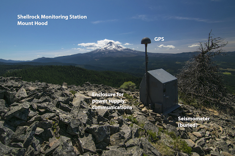
- Ground movement and distortion of GPS signals tell us about volcanic hazards.
- Volcano observatories around the globe create arrays of GPS receivers to monitor shifts in the ground surface that might indicate the underground movement of magma. During the eruption of Hawaii’s Kīlauea volcano in 2018, officials used this type of information to guide evacuation decisions.
- Researchers have also found that volcanic plumes of ash distort the arrival of GPS signals near volcanoes. Since these clouds of glassy ash particles create a hazard for jet engines, GPS can be used to monitor the movement of plumes as they rise into different layers of the atmosphere and determine safe detours for air travel.
- Delay of GPS signals also indicates volumes of snowfall, rainfall, and potential for flash floods.
- Water vapor and particulates in the atmosphere also delay GPS signals just enough that meteorologists can use the information to calculate how much water is available to precipitate as rain or snow.
- This information was used in 2013 to issue a warning to residents 17 crucial minutes before a flash flood hit a California neighborhood.
- This information is used to fine-tune expected snowfall accumulation during blizzards.
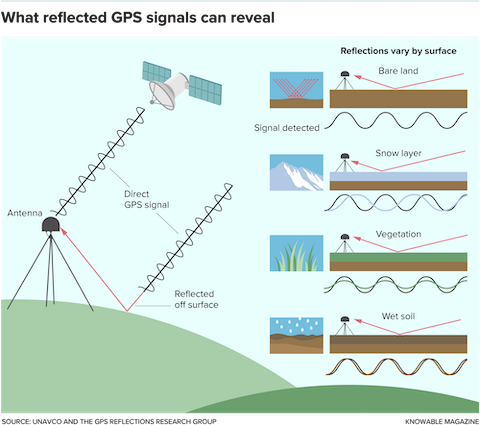
- Reflected GPS signals help identify changes in vegetation, soil moisture, and snowpack.
- GPS signals arrive through the atmosphere from satellites, but they also bounce back off of the ground. Some of that results in noise, but some of it carries recognizable GPS frequencies that can be used to monitor changes in the characteristics of the ground surface.
- Variations in vegetation and soil moisture can be tracked in remote areas using these reflected GPS signals.
- Amount of snowfall can be measured using the change in the shift of the reflected GPS signal. These measurements can be used in calculating avalanche danger as well as determining how much water may be stored as snowpack in a watershed for the spring melt.