You’ve probably used GPS today, in ways you don’t even know about.
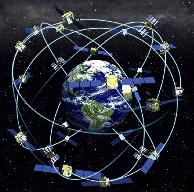
Of course, your smartphone is a miracle of GPS navigation. It receives data from a network of 31 satellites orbiting about 12,000 miles above us—at least 4 of them are visible from any place on Earth at any time. It uses that data to pinpoint your location to within 10 feet. Pretty amazing.
But there are many other ways that GPS impacts our lives. It helps airline pilots and ship captains stay on course. It helps taxis find their fares and military missions find their targets. And it plays important roles in bank transactions and power grids.
In fact, because the GPS satellite network is even more stable than the shifting surface of the planet, scientists now use it to track continental plate movement.
It shows that Australia moves as fast as fingernails grow, about 3 inches a year, while Hawaii holds the record, moving toward Japan at 4 inches a year.
Geodetic surveys correct GPS coordinates for the shifting earth and send updates to our devices on demand.
And the whole thing is about to get more precise. The next generation of GPS will use both satellite and ground stations to be accurate to within 1 inch.
We’ll need it, as future technologies like driverless cars, delivery drones, and things we can’t even yet imagine, rely on GPS for increasing precision.
Background
Synopsis: The satellite network that informs our GPS system stays in a stable Earth orbit while the tectonic plates that we live on are in constant motion. As a result, coordinate systems have to be occasionally reset and continuously adjusted for GPS to ensure correct locations are provided. These adjustments are becoming more important with advanced technologies that will rely on GPS with 1-inch precision in the future; currently, the resolution is about 10 ft.
- The Global Positioning System (originally Navstar GPS) is owned and operated by the United States.
- GPS was originally developed by the military in the 1970’s but was not broadly used by the public until the mid-1990’s.
- GPS uses simultaneous signals from several satellites to pinpoint locations on Earth within about 10 ft.
- The GPS constellation has 32 satellites in semi-synchronous orbit—meaning that the satellites rotate twice as fast as Earth does, appearing to circle the planet once a day. Many other communications satellites are geosynchronous, meaning they rotate at the same rate as Earth, appearing to stay in the same place.
- GPS is used for navigation, scientific research, weather forecasting, earthquake monitoring, environmental monitoring, emergency services, and disaster relief.
- GPS is essential to our global-information infrastructure and impacts just about every aspect of our lives, from cell phones to banking systems to power grids to remotely operated vehicles and drones, as well as virtually every facet of U.S. military operations.
- Russia, Europe, China, Japan, and India have global-navigation satellite systems of their own, which, if used along with the GPS constellation of the United States, can increase its accuracy five times, from about 10 ft to about 2 ft.
- The next generation of GPS will be accurate to within 1 inch, using both satellite and ground stations; with this level of precision, GPS will support advanced technologies that we may not yet have thought about.
- Our global-navigation satellite systems are more stable than the constantly moving surface of Earth, so scientists use GPS for many purposes, including measuring the lateral and vertical motion of Earth’s tectonic plates.
- Most plates move less than 1 inch per year, but the speed record goes to the Pacific Plate, where islands like Hawaii are moving toward Japan at 3 to 4 inches per year—about 5 ft every 20 years. The fastest-moving continent is Australia, which moves northward about as fast as fingernails grow, 2.7 inches per year. People in Hawaii and Australia don't feel the motion, but GPS does!
- One place in the United States where people definitely feel the motion is the West Coast of California, including Silicon Valley with its driverless cars. This coast is moving northwest at an average of 1–2 inches per year relative to Sacramento along the San Andreas Fault system.
- Plates can make larger jumps when earthquakes occur; during the March 11, 2011, earthquake in Japan, the island of Honshu moved a full 8 ft eastward, toward Hawaii.
- Scientists at geodetic surveys around the world maintain the systems that track the movement of continents and provide real-time corrections along with satellite-location data to our digital devices each time we pinpoint our location—to ensure we stay on the road! Every few years, they adjust data where needed.