Credit: Roland Unger, CC BY-SA 3.0, via Wikimedia Commons
In 1933, Hungarian explorer László Almásy set out across the Sahara in search of a legendary lost city. What he discovered was far more magical and, at first, completely unbelievable.
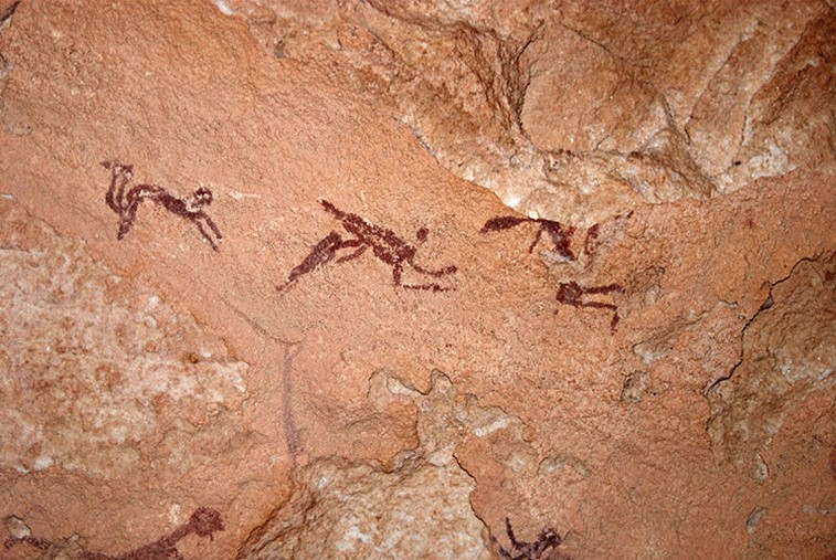
In a remote ravine, Almásy found a shallow cave. Inside he saw cave paintings of human figures with outstretched arms and legs. They appeared to be flying. But no, Almásy realized, they were swimming—in the Sahara!
Other cave paintings showed antelope, giraffe, elephants and lions alongside more human figures. Almásy realized they depicted a Sahara of grasslands with abundant water.
His theories were met with skepticism but sparked further investigation. And geologic studies eventually proved him right!
Those cave paintings dated from what’s now called the African Humid Period, which lasted from the end of the last Ice Age until 5,000 years ago.
It was caused by a thousand years of African monsoons, brought on by changes in the wobble of Earth’s axis. These greened the Sahara and formed vast lakes.&
More than 150 excavations uncovered the remains of aquatic species like hippos, crocodiles and more than 30 types of fish.
Further investigation showed the Sahara has alternated between desert and wet grasslands every 20,000 years or so—for hundreds of thousands of years.
Background
Synopsis: In 1933, in an extremely remote area of the Sahara Desert in southwestern Egypt, explorer László Almásy discovered cave rock art depicting human figures that appear to be swimming. He proposed the shocking idea that the Sahara had once been green, and he was right! Geologic studies indicate that the Sahara has been green many times, with a cyclicity of about 20,000 years. So, 9,000 years ago during the Neolithic period, the people of the region could very well have been swimmers.
- The Sahara Desert is the largest hot desert on Earth, covering most of North Africa, with an area of 3,600,000 mi2 (9,200,000 km2) of rock outcrops and windswept dunes.
- It is about 3,000 mi (4,800 km) wide east to west and 1,100 mi (1,800 km) wide north to south, just slightly smaller than the contiguous 48 states of the United States.
- Chad’s Mount Koussi is its high point, at 11,204 ft (3,415 m), while Egypt’s Qattara Depression lies 436 ft (143 m) below sea level.
- The desert is vast, inhospitable, and largely inaccessible, which makes it all the more mysterious.
- László Almásy (1895–1951) was a Hungarian aristocrat who became an aviator and Sahara Desert explorer between the World Wars, in the early 20th century.
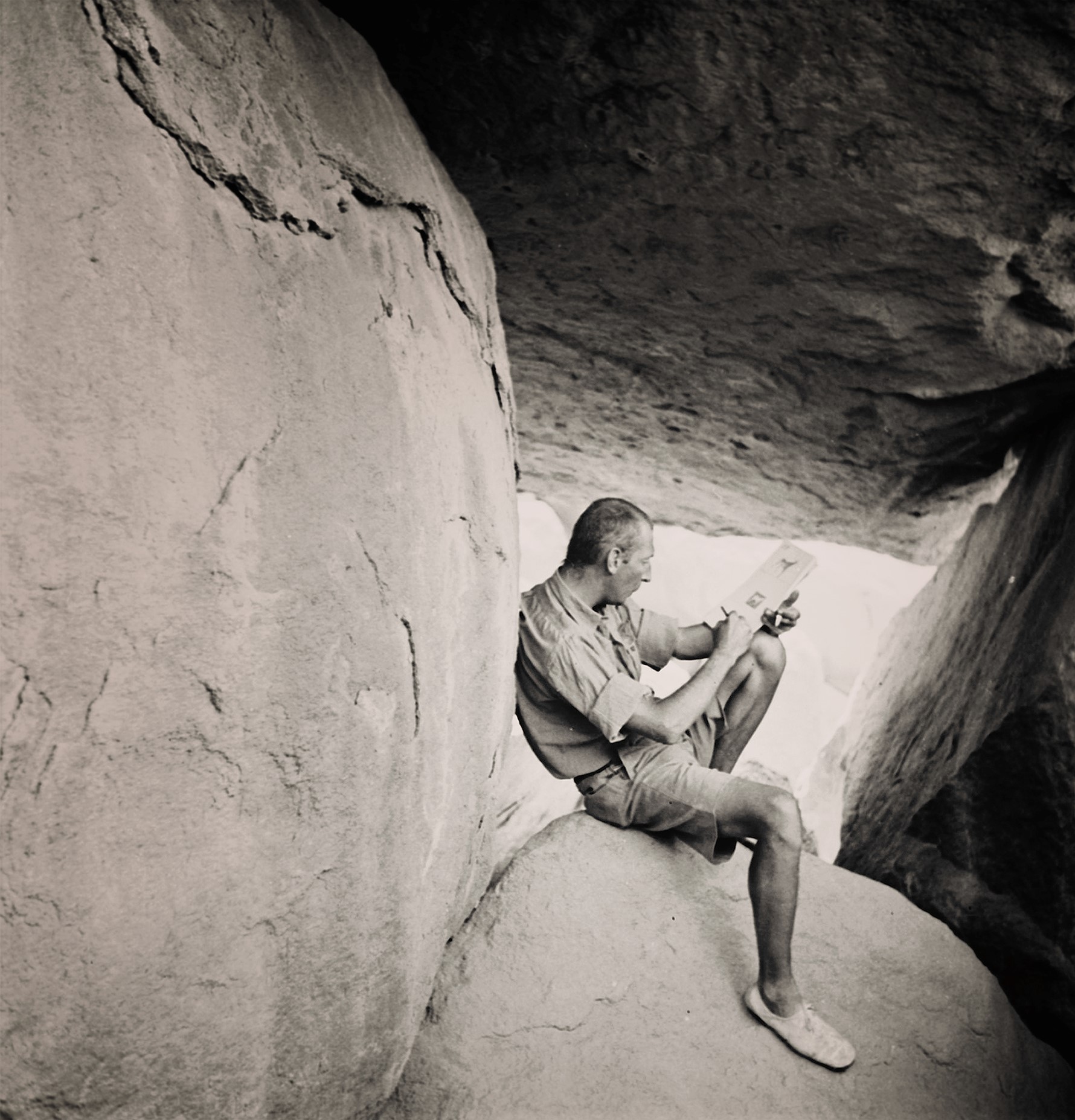
László Almásy sitting on a desert rock outcrop in the 1930s.
Credit: The Rock Art of Gilf Kebir, Egypt, via the Bradshaw Foundation- In 1932, Almásy and his partners set off on a cartography expedition in search of the mythical city of Zerzura, deep in the Sahara desert, with two cars and a De Havilland Gipsy Moth airplane.
- In 13th century writings, Zerzura was known as “the White City” or “the Oasis of Little Birds,” supposedly inhabited by tall, fair-haired, blue-eyed people and filled with treasure, but it had never been located.
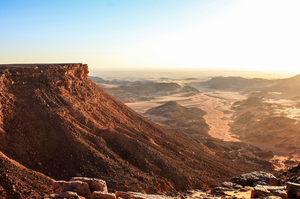
View from the Gilf Kebir ridge to the south into the valley of Wadi Sura. Gilf Kebir means “Great Barrier” in Arabic. It is the size of Puerto Rico and rises 980 ft (300 m) from the desert floor.
Credit: Clemens Schmillen, CC BY-SA 4.0, via Wikimedia Commons - The explorers flew over the mountainous Gilf Kebir plateau and located a vegetated valley oasis but were unable to reach the valley mouth by car until the following spring. It was uninhabited but was confirmed as one of the three valleys of the ancient Zerzura by a tribal elder.
- Almásy and crew continued exploration in the area, locating a number of prehistoric rock-art sites. In October 1933, the explorers set out to catalog them and explore additional sites.
- Many of the rock-art sites they documented in this remote, inhospitable environment depicted bountiful scenes of mammals (gazelles, antelope, lions, giraffes and elephants) alongside human figures.
- Upon entering a shallow cave called Wadi Sura (also called Wadi Sora) along the southern edge of the Gilf Kebir plateau, the explorers discovered a panorama of rock-art pictographs featuring hand-sized figures in swimming-like poses. You can view the whole panel via this interactive three-dimensional view of the Cave of Swimmers rock art.
- This discovery was made famous as a key film element (via a film set, not the real cave) of the fictional story told in Michael Ondaatje’s novel The English Patient, which was made into a feature film in 1996. The novel’s protagonist, portrayed by Ralph Fiennes, is thought to have been fashioned as a charismatic blend of Almásy and some of his desert exploration partners.
- In his 1934 book, The Unknown Sahara, Almásy suggested the radical idea that the Sahara has not always been a desert. He was right!
- He postulated that these swimming figures demonstrate daily-life activities and the existence of abundant water in the region when they were painted.
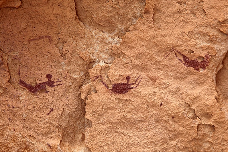
These additional figures in swimming poses were painted by Neolithic artists on the walls of Wadi Sura.
Credit: The Rock Art of Gilf Kebir, Egypt, via the Bradshaw Foundation - Others thought the figures might represent ghosts floating eerily on their way to the afterlife.
- He postulated that these swimming figures demonstrate daily-life activities and the existence of abundant water in the region when they were painted.
- Geologic evidence has now shown that Almásy was right—the Sahara has been a green savanna with rivers and freshwater lakes, not just once but many times.
- The Wadi Sura figures were created between 9,000 and 6,000 years ago by Neolithic painters during the African Humid Period, which lasted from about 11,500 to 5,000 years ago.
- The African Humid Period was initiated by strong West African Monsoon conditions related to increased solar radiation caused by Earth’s orbital cycles (ED-214 Earth’s Odd Orbit).
- Around 12,000 years ago, the region was dry and extended 250 mi (400 km) south of its current southern boundary. Then, about 10,000 years ago, monsoon rains began to sweep through the area.
- After about a thousand years, the Sahara was covered in green forests and open grasslands where wildlife thrived.
- Wide rivers and huge paleolakes filled with freshwater catfish and tilapia, providing humans of the region with rich fishing grounds. This is the likely setting for the rock art of Wadi Sura.
- More than 500 radiocarbon dates help tell the story of humans and animals in more than 150 excavation sites in the region. Wildlife included elephants, rhinos, hippos, crocodiles and more than 30 species of fish, some as long as 6 ft (2 m).
- About 5,500 years ago, the monsoon belts shifted farther south and so did the mammals. Vegetation declined and the region became barren again.
- Some researchers have suggested that a shift to herding and farming practices around 7,300 years ago may have influenced the timing of desertification and the departure of humans around 5,500 years ago.
- These humans were climate refugees, many of whom emigrated to the fertile Nile Valley to eventually forge the pyramids of the pharaohs of Egypt.
- Wind erosion stripped the land, leaving dusty depressions filled with the remains of freshwater diatoms that are still blown across the Atlantic to fertilize the Amazon basin (ED-024 Dust in the Wind).
- The African Humid Period is just the most recent of a long series of Green Sahara Periods (GSPs). Scientists have documented dozens of these cycles.
- While there are multiple contributing factors, the main culprit in the development of GSPs is Earth’s axial wobble (precession) that cycles about every 20,000 years, sometimes exposing the Northern Hemisphere to 4% to 8% more insolation in the summer.
The shape of Earth’s orbit becomes more or less oval (eccentricity), Earth wobbles as it spins (precession), and Earth’s axis changes, too (tilt). All these changes, over thousands of years, cause variation in Earth’s insolation, which affects climate.
Credit: Windows to the Universe - During a GSP, with the Northern Hemisphere tilted more toward the sun in the summer, the landmass heats up, producing a huge low-pressure system over North Africa that draws in moist air from the Atlantic, resulting in a strong southwesterly monsoonal flow that delivers precipitation to the region (ED-271 Monsoon Rains).
- Rich organic material washes down the Nile into the Mediterranean Sea, forming numerous dark sapropel horizons that have been documented in cores.
- At the opposite end of the cycle (like today), when the wobble tilts the Northern Hemisphere away from the sun in summer, monsoon activity weakens, ending the humid part of the cycle. The region becomes dry and desolate, and dust blows northeastward into the Atlantic Ocean and Mediterranean Sea, leaving telltale repetitive layers in ocean-floor sediments that can be analyzed from cores.
- While there are multiple contributing factors, the main culprit in the development of GSPs is Earth’s axial wobble (precession) that cycles about every 20,000 years, sometimes exposing the Northern Hemisphere to 4% to 8% more insolation in the summer.
- A large amount of global research has been going on to understand the mechanisms that drive this cyclical Sahara desertification.
- In 2013, researchers from Australia compiled existing data to create maps of physiographic elements of the Sahara today and during two GSPs centered on 8,000 and 125,000 years ago.
North African vegetation today and during two past Green Sahara Periods (GSPs), with principal type of vegetation and mean annual precipitation by latitude in graphs to the left of each map. These figures from a 2013 study illustrate the expansion of the savanna relative to today. Figure A shows present-day conditions, B shows the Holocene GSP from 10,000 to 6,000 years ago, and C shows the even greener Eemian GSP from 128,000 to 122,000 years ago.
Credit: Juan C. Larrasoaña, Andrew P. Roberts, and Eelco J. Rohling, CC BY 4.0, via Wikimedia Commons - In 2019, MIT researchers used a new thorium isotope technique to analyze sediment accumulation rates from Atlantic Ocean cores, demonstrating that the Sahara swung from wet to dry climates on a regular cycle every 20,000 years for at least the past 240,000 years.
- Saharan dust that is at least 4.6 million years old, from about a million years before glaciation began in the Northern Hemisphere, has been documented by U.S. Geological Survey scientists on the Canary Islands and in Atlantic Ocean core. The Sahara was a desert long before the Pleistocene Epoch began.
- From about 5.97 to 5.33 million years ago, the Mediterranean dried up during the Messinian Salinity Crisis (ED-054 The Mediterranean Desert).
- Cyclic desertification may have been going on in the Sahara region for as long as 9 million years when the forces of plate tectonics finally closed the Tethys Sea in the Miocene Epoch, changing the distribution of land and ocean as well as atmospheric circulation patterns.
- In 2013, researchers from Australia compiled existing data to create maps of physiographic elements of the Sahara today and during two GSPs centered on 8,000 and 125,000 years ago.