Credit: Roger Pibernat under supervision of Daniel Garcia-Castellanos (CC BY-SA 3.0 [https://creativecommons.org/licenses/by-sa/3.0]), via Wikimedia Commons
The Mediterranean Sea: birthplace of European civilization, and still its favorite vacation spot. You’d never know that, not too long ago, it was a desert filled with salt, with temperatures over 150 degrees.
About 6 million years ago, growing ice sheets in Antarctica began to trap Earth’s water and lower sea levels. Waters in the Strait of Gibraltar, that narrow channel between Spain and Morocco, began to recede.
Freed from the weight of the water, the land began to rise. Which caused a feedback loop of shallower waters and more rising seafloor, till the strait … became a dam, and the Mediterranean was separated from the Atlantic.
Within a thousand years, the Mediterranean had almost completely dried up, leaving a desert basin nearly 2 miles deep. Over several hundred thousand more years, it was partially filled and dried out again many times, leaving layers of salt and gypsum, in some places more than a mile thick.
Around 5 and a half million years ago, the major ice sheets began to melt, and a rising Atlantic breached the dam. Water rushed into the Mediterranean, carving a channel a mile wide and 100 miles long.
Scientists estimate it filled the entire Mediterranean again in less than 2 years, and in short order, one of the Earth’s most inhospitable places became one of its richest, teeming with life.
Background
Synopsis: The idea of “the Mediterranean” evokes visions of exotic vacation spots from the Riviera to the Greek Isles—warm, deep blue waters lapping onto dramatic beaches. Or you might think about the rich Greek, Phoenician, and Roman civilizations that flourished in this fertile region. But about 5 and a half million years ago it was a much different place—a hellishly hot desert in a very large, deep basin. This is when water from the Atlantic suddenly broke through, flooding the basin at amazing rates to fill the Mediterranean Sea in about 2 years.
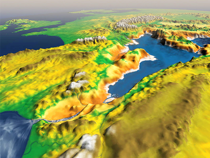
- The present-day Mediterranean has a very complex bathymetry, with multiple subbasins such as the Alboran Basin, Tyrrhenian Sea, Adriatic Sea, and Aegean Sea.
- The Mediterranean Sea formed during repeated, messy collisions of the African–Arabian plate with the Eurasian Plate and nearby microplates during the Alpine orogeny.
- A sill near the island of Sicily separates it into western and eastern segments.
- The Mediterranean has an average depth of about 4,900 ft; its deepest point is the Calypso Deep at more than 17,000 ft. The sea is about 2,500 miles wide from east to west, about the distance from Atlanta to San Francisco.
- The Mediterranean is nearly landlocked, with only narrow outlets to the Atlantic through the Strait of Gibraltar, to the Red Sea through the Suez Canal, and to the inland Black Sea through the Turkish Strait and the Sea of Marmara.
- The largest of the outlets is the Strait of Gibraltar, which separates Europe and Africa by a mere 9 miles. Homer referred to the bluffs on either side of the strait as the “Pillars of Hercules.”
- Because evaporation from the Mediterranean is 2–3 times the precipitation and runoff into it, inflow from the Atlantic through the Strait of Gibraltar is critical to maintain the sea’s volume and salinity.
- Today, the delicate balance of water inflow and outflow through the strait depends upon the narrow channel, which has water depths ranging from about 1,000 to 3,000 ft. If the ground surface rose, or if the sea level dropped, the connection to the Atlantic could be broken.
- Without any recharge from the Atlantic, today’s Mediterranean would dry up in about 1,000 years, leaving evaporite layers hundreds of feet thick.
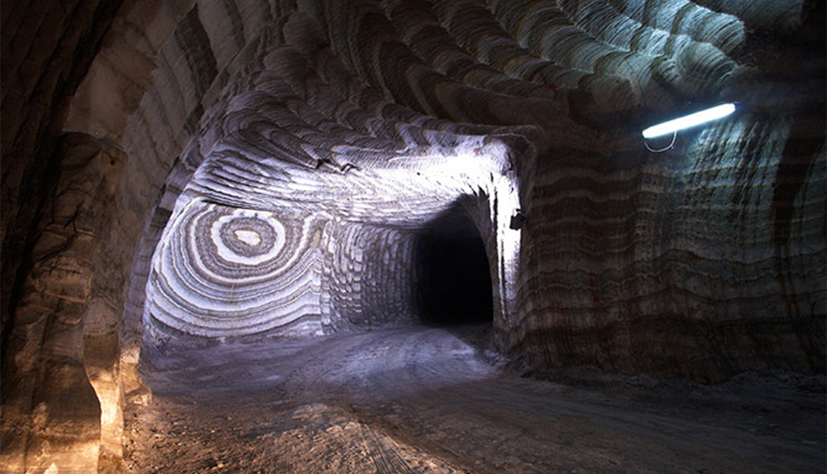
- Many researchers believe the Mediterranean Sea did dry up, starting about 5.97 million years ago, leaving behind thousands of feet of salt deposits: 6 percent of the NaCl on Earth, which is many times more than could be explained by a single evaporative event.
- In the 1970s, researchers from the Deep Sea Drilling Project drilled into the Mediterranean seafloor and found more than 4,000 ft of Messinian salt and evaporite deposits buried beneath the muddy sediments.
- They also found wind-deposited dune material like that in a desert, as well as desiccation cracks filled with younger material, indicating the ground had dried up.
- Seismic data show that the salt layer continues all around the deep basin.
- Rivers entering the Mediterranean show evidence (from seismic data and drilling) that they cut valleys downward, seeking base level for the shrinking basin. The Nile River cut its banks down to at least 500 ft below sea level at the time.
- Halite deposits show hundreds of cyclical bands of organic material, indicating a repetitive process of salt precipitation and brine replenishment.
- How were these deposits created?
- As the irregular edges of the African plate crushed into the southern Iberian Peninsula, the Mediterranean became closed off from the Atlantic, leaving various river inlets in northern Morocco and southern Spain to feed Atlantic water into the isolated, desiccating basin down a long eastward dipping ramp.
- Some scientists believe the evaporite deposits formed through direct evaporation on the exposed basin floor, but some hypothesize that evaporite minerals precipitated within high-salinity brines and settled through the water column into deep parts of the basin.
- During distant summer seasonal rains in Africa, some rivers delivered surges of fresh water into the basin, causing pulses of biological life that stripe the salt. The timing of these wet periods has been tied to a 20,000-year cycle related to the wobble of Earth’s axis, known as precession.
- Fresh and briny waters entered the basin periodically for a couple of hundred thousand years, flooding the basin and evaporating or precipitating over and over again to form a thickness of more than 4,000 ft of evaporites.
- Based on bathymetry, the exposed abyssal plain of the Mediterranean was 5,000–10,000 ft below sea level.
- Today, the lowest dry place on Earth is by the Dead Sea, at more than 1,400 ft below sea level. Death Valley is 282 ft below sea level.
- A basin 1–2 miles deep would be heated adiabatically and would probably be 75–175oF warmer than the temperature at sea level, far too hot for life other than extremophiles. The heat would also accelerate evaporation.
- About 5.33 million years ago, the land around Gibraltar subsided enough to allow a constant flow of Atlantic water to overtop the strait, marking the beginning of the Zanclean flood.
- For the first few thousand years of flooding, the flow into the Mediterranean was fairly slow—down the gradual ramp that ran from the Atlantic into the basin.
- In less than 2 years, 90% of the water needed to fill the Mediterranean flowed through the gap, creating a 125-mile-long channel incised by waters flowing between 60 and 150 mph.
- The flood is thought to have raised the level of the Mediterranean by 30 ft per day; the region went from being devoid of life to having bountiful marine life in just 2 years—a blink of an eye in geologic time.
- Today, huge volumes of ship traffic move through the narrow Strait of Gibraltar.
- Atlantic Ocean water flows eastward at the surface to replenish the evaporative losses of the Mediterranean.
- Around 330 ft below the sea surface, the more saline Mediterranean water flows westward into the Atlantic and tumbles in dense currents down to the Atlantic basin floor.
- During WWII, German submarines, or U-boats, would turn off their engines and float into the Mediterranean with the Atlantic Ocean water to avoid detection.
Credit: Church of the Realmonte Mine: Salt of the Earth | ItalianWays.com