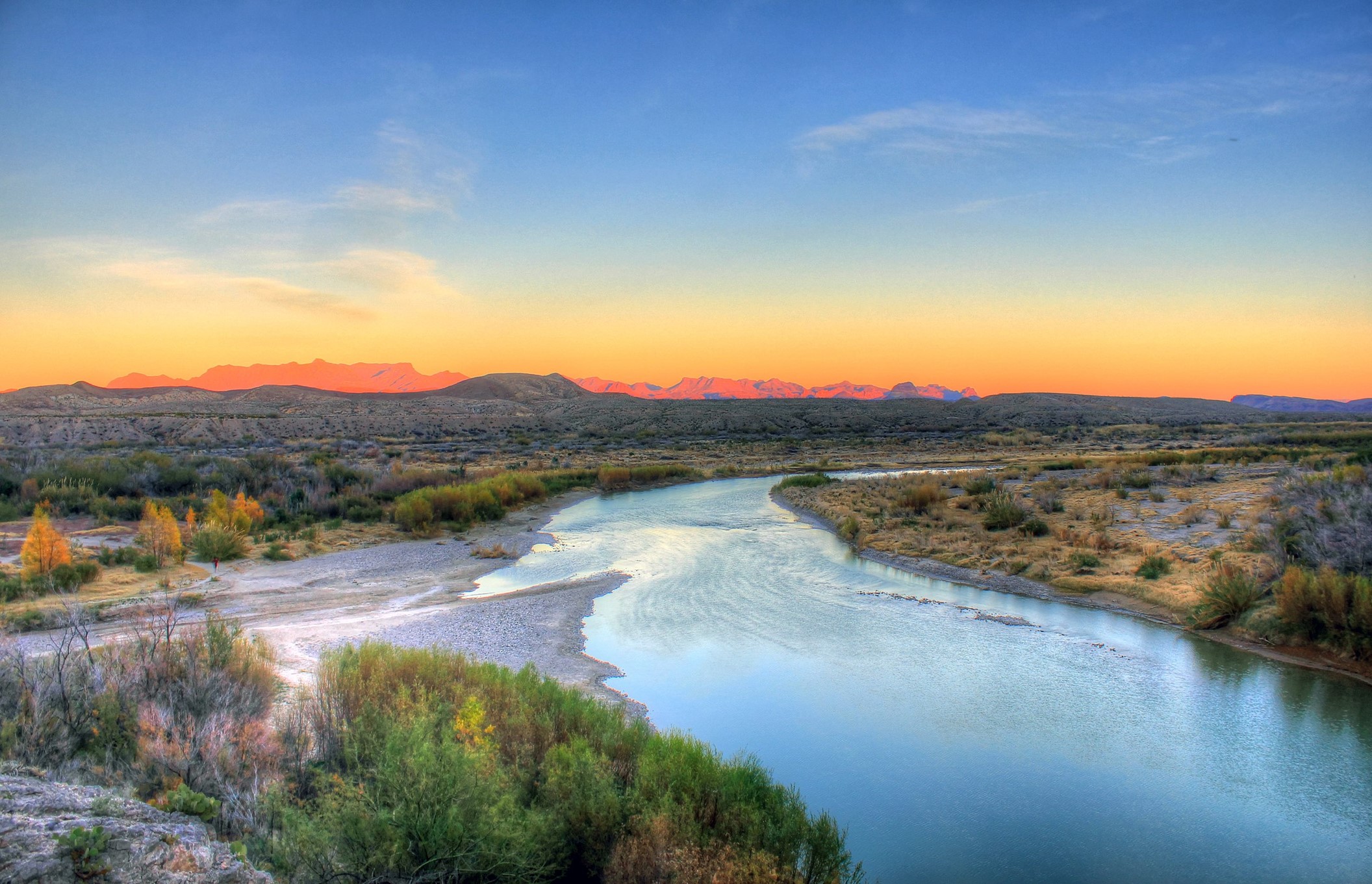
Credit: Yinan Chen, public domain, via Wikimedia Commons
Native American legend says the Creator, when done forming Earth, threw all the leftover rocks into a pile in West Texas—a jumble of geology that today we call Big Bend.
It gets that name because it sits in a 200-mile-long curve in the Rio Grande River that separates Texas and Mexico. Big Bend is now a nearly million-acre national park—with a protected area twice as large on the Mexican side of the border.
The reason it looks like a divine rock yard is its complicated geologic history.
450 million years ago, Big Bend was on the coast of the supercontinent of Laurasia. Around 300 million years ago, Africa slammed into it, crumpling the Big Bend region.
200 million years ago, the continent of South America tore off from this area. 100 million years later, Big Bend was submerged beneath the Cretaceous Interior Seaway, a giant sea that bisected North America from the Gulf of Mexico all the way to the Arctic Ocean.
Around 60 million years ago, the Rockies and Mexico’s Sierra Madre mountain ranges began rising and met in Big Bend. And if that wasn’t enough, the area was rifted then became volcanically active 40 to 30 million years ago.
You can see evidence of this complex geologic history in the hills, outcrops and steep canyon walls of Big Bend today, which makes it a dream destination for hikers, campers and geologists.
Background
Synopsis: The “Big Bend” in the Rio Grande that forms the iconic shape of West Texas is located at the intersection of a number of geologic events that occurred over hundreds of millions of years. Big Bend National Park’s sparse desert vegetation reveals its remarkably complex geology, a geologist’s paradise—and nightmare.
- The name “Big Bend” comes from the abrupt northeastward curve in the Rio Grande River as it runs between the Chisos Mountains of Texas and the northern end of Mexico’s Sierra Madre Oriental. The river later switches back to a southeastward course from its junction with the Pecos River to the Gulf of Mexico.
- The Rio Grande River is the fourth longest in the United States at 1,896 mi (3,051 km), with its headwaters in the San Juan and Sangre de Cristo Mountains of southern Colorado.
- Its two largest tributaries are Mexico’s Rio Conchos, with its headwaters in the Sierra Madre Occidental; and the Pecos River that drains eastern New Mexico and West Texas.
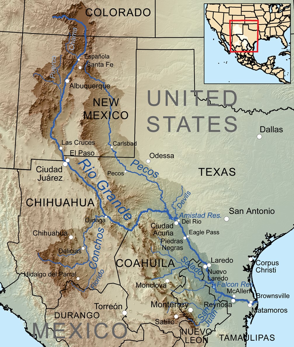
Map showing the Rio Grande and its tributaries within the Rio Grande drainage basin.
Credit: Kmusser, CC BY-SA 3.0, via Wikimedia Commons - The Big Bend region is the southern part of the Trans-Pecos region of West Texas, along its border with Mexico, north of the Rio Grande in the rugged Chihuahuan Desert.
- Big Bend National Park is one of the main attractions in the region and occupies 801,163 acres (3,242 km2) inside the bend of the Rio Grande. Because of the prominence of the large bend in the river, it’s one of the few U.S. national parks that can clearly be located from space.
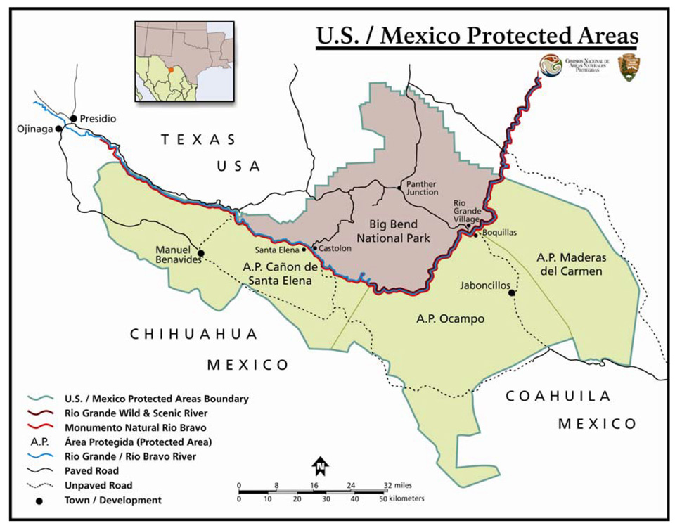
Big Bend National Park is adjacent to three large protected land areas across the river, in Mexico.
Credit: National Park Service - 330 mi (530 km) of the river are protected on the Mexican side as the Rio Bravo del Norte protected area, while on the U.S. side, 196 river mi (315 km) are protected as the Rio Grande Wild and Scenic River, 65% of which are downstream of Big Bend National Park. Mexico declared three protected areas along the southern bank of the river (see ED-372 Big Bend National Park is 80).
- Big Bend National Park’s geology is well exposed in the desert environment, making it a geologist’s dream, but it is also a geologist’s headache because of the complexity that is a consequence of a number of geologic events that overlapped there through time.
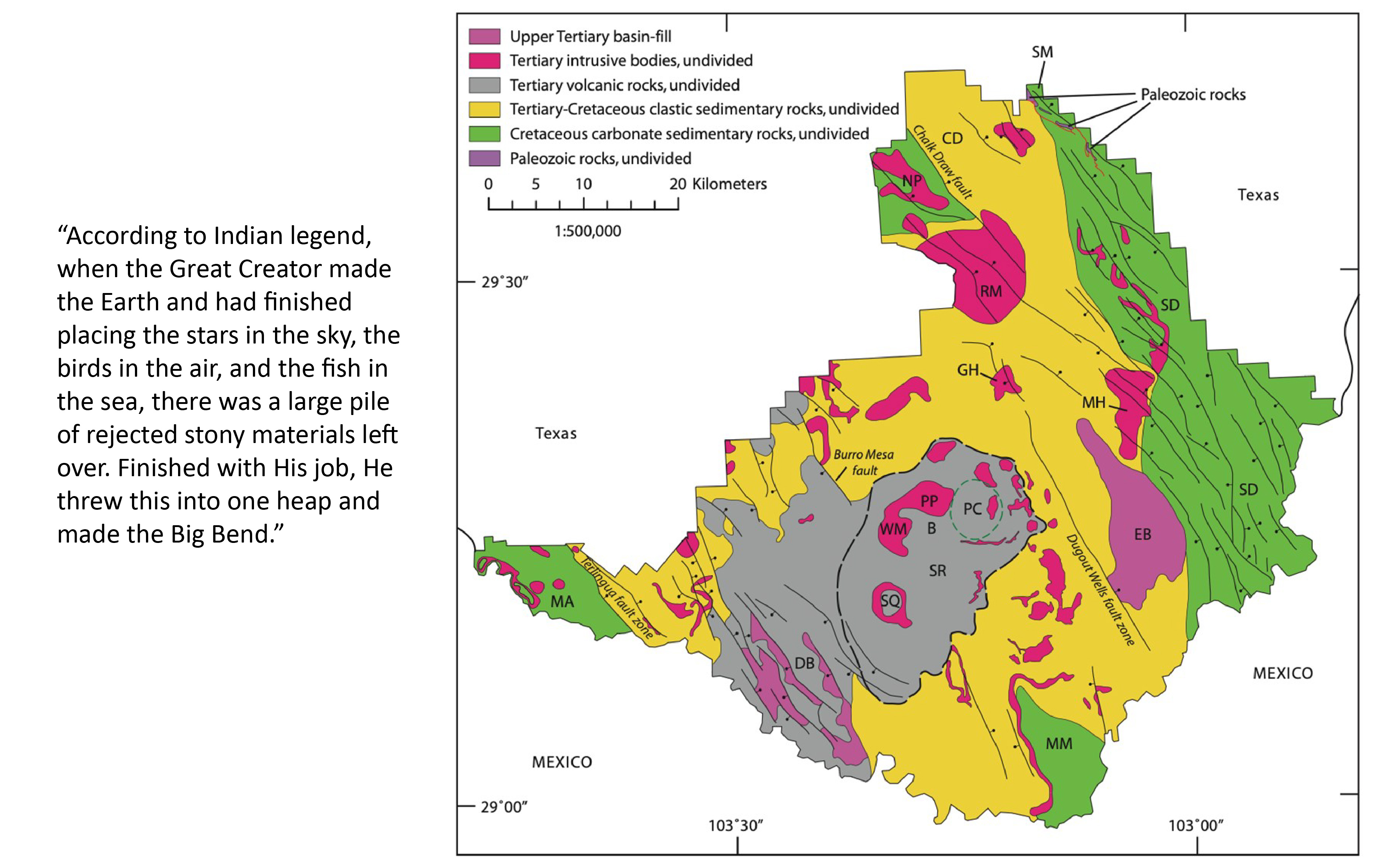
Simplified geologic map of Big Bend National Park.
Left quote credit: Ross Maxwell in The Big Bend of the Rio Grande: a Guide to the Rocks, Geologic History, and Settlers of the Area of Big Bend National Park
Right map credit: USGS Circular 1327- The area that is now Big Bend National Park occupied a coastal position on the Paleozoic supercontinent of Laurasia. The 450 million-year-old late Ordovician rocks exposed near the Persimmon Gap park entrance represent this period.
- Around 330 to 285 million years ago (Pennsylvanian–Permian time), Africa crashed into Laurentia, and the Big Bend region ended up at the crumpled western edge of the Ouachita–Marathon orogeny (that was contiguous with the Appalachian Mountains).
- Starting about 200 million years ago (Triassic time), South America rifted southward.
- Around 135 to 100 million years ago, the region was flooded by the Cretaceous Interior Seaway, which extended from the Gulf of Mexico through Big Bend and the western United States and Canada to the Arctic Ocean. The marine rocks around Boquillas and Santa Elena Canyons were deposited during this episode.
Visitors can paddle between walls of Cretaceous marine limestones in the dramatic Santa Elena Canyon in boats or kayaks. In this photo, the boats are headed downstream, with the United States on the left and Mexico on the right.
Credit: David, CC BY 2.0, via Wikimedia Commons - In the Late Cretaceous, 80 to 70 million years ago, the compression of the Laramide Rockies began, ultimately extending as far south as the park. The Tornillo Basin formed as a Laramide graben between Mesa de Anguila and Sierra del Carmen that included most of the park. Mariscal and San Vicente Mountains and many other structures were formed by folding and faulting during this event, which ended in the Eocene Epoch around 50 to 40 million years ago.
Looking over the red rhyolites of the Oligocene Chilicotal laccolith (in Texas) toward the striking white Santa Elena Limestone cliffs of the Sierra del Carmen at the northern end of Mexico’s Sierra Madre Oriental Range.
Credit: Juli Hennings, Bureau of Economic Geology - In the southeastern part of the park, the white Sierra del Carmen limestone cliffs represent the northernmost extent of Mexico’s Sierra Madre Oriental, a 700-mi-long (1,000 km) mountain range that formed between 60 and 23 million years ago. These mountains demonstrate a different style of compressional folding than the contemporaneous Laramide Rockies in the United States.
- The park occurs at the southeastern end of the Trans-Pecos magmatic province that was active from about 46 to 28 million years ago. Many of the park’s volcanic and igneous features formed during this time, including the Chisos Mountains, twisting dikes, and many blister-like intrusions known as laccoliths. One of the many things that make Big Bend National Park unique is that the Chisos range is the only mountain range that is completely inside a U.S. national park area.

Sunrise view of the Chisos Mountains from the south, taken from the Dodson Trail. Iconic hiking trails run along the cliffs of the “South Rim” on the left, while Crown Mountain and the Pine Canyon caldera is on the right.
Credit: Juli Hennings, Bureau of Economic Geology - Big Bend National Park occurs at the southern extent of the Rio Grande rift that began in the late Eocene (36 million years ago) and is one of just five active rifts on Earth today. The rift made its way southward gradually from Colorado and New Mexico, reaching the western part of the park around 2.3 million years ago.
- The eastern extent of the Miocene Basin and Range province occurs in the park. The Terlingua and Santa Elena fault zones reactivated along the boundaries of the Tornillo Basin, while shallow basins surrounding the Chisos Mountains subsided further and filled with Miocene to Pliocene sediments from 23 million years ago until 2 million years ago.
A digital elevation model of the area in and around Big Bend National Park. The Chisos Mountains (center) and the northernmost extension of Mexico’s Sierra Madre Oriental, Sierra del Carmen (right), are shown in yellow.
Credit: Martin D. Adamiker, CC BY-SA 3.0, via Wikimedia Commons - The Rio Grande River finally cut northeastward through the area about 2 million years ago, joining the southeastward-flowing Pecos River around 800,000 years ago, completing its journey to the Gulf of Mexico.
The physiographic order of the Big Bend is somewhat like the order of a great city built of stone and brick—wrecked by an earthquake. Perhaps order once prevailed there, but some mighty force wrecked the place, shook it down, turned it over, blew it up, and set it afire. Evidences that all this happened exist on every hand, making the land the finest example of earth-wreckage in Texas.
Credit: Walter Prescott Webb, Texas historian, 1937