Credit: National Park Service, public domain, via Wikimedia Commons
In 1797, in central Kentucky, a hunter chased a bear into a hole in a cliff … and discovered the longest cave network in the world, 10 million years in the making.
But at that time, all he could see—and smell—was bat guano, which was then the valuable source of saltpeter, a key component in gunpowder.
Within a year, prospectors were mining centuries of bat droppings for military efforts. During the War of 1812, the gunpowder business boomed, and so did the cave’s mine. In 1815 the war ended, and so did the mine.
The next year, Mammoth Cave, named for its enormous size, opened as a tourist attraction. The slaves who had been the miners now served as tour guides.
They showed the cave to Gilded Age patrons, who carried oil lamps and used their smoke to write their names on the ceiling.
In the 1840s, a freed slave named Stephen Bishop, an expert cave guide, was the first to explore and map the cave.
After a century of tourism, it was thought to comprise more than 40 miles of caverns and connected passages.
But new scientific exploration and technology, continuing to the present day, has revealed it’s actually 10 times that size. And more rooms are expected to be found.
Today, the cave’s petroglyphs and speleothem formations are seen by half a million visitors a year. If you find yourself in Kentucky, be one of them!
Background
Synopsis: The world’s longest labyrinth of caverns, grottoes, sinkholes and springs can be found at Kentucky’s Mammoth Cave National Park. Forming over the course of more than 10 million years, the cave system preserves a record of geological history overlain by thousands of years of human history.
- Mammoth Cave National Park is the world’s longest cave system, exhibiting one of the widest varieties of cave formations known to humankind.
- It is located in south-central Kentucky, just north of I-65 about 30 mi (~50 km) northeast of Bowling Green.
- The name “Mammoth Cave” refers to the sheer size of its chambers and passageways and first appeared in public records in 1812. The name does not refer to the woolly mammoth, and no fossils of the extinct giant beasts have been found in the cave.
- Mammoth Cave National Park was established in 1941 to preserve the magnificent cave system.
- Most of the 52,830 acres (82.5 mi2, 214 km2) of the park is rolling hills with thick forests surrounding the lush Nolin River and Green River valleys, including 60 mi (96.5 km) of backcountry hiking and biking trails.
Mammoth Cave National Park boundaries and an inset map showing the park headquarters.
Credit: National Park Service - More than 4,000 people tour the caves every day, totaling about one-half million visitors per year.
- So far, 27 entrances have been found and mapped, but only 6 are used by visitors for various tour experiences. The Historic Entrance is the largest natural entrance.
- The temperature in the caves is a constant 54°F (12°C), and humidity is 87%.
- Considered to be a global biodiversity hotspot, with over 130 cave-dwelling species, the park was listed as a UNESCO World Heritage Site in 1981.
- Mammoth Cave National Park was designated an International Biosphere Reserve in 1990, and it became an International Dark Sky Park in 2021.
- The Mammoth–Flint Ridge Cave System has been mapped at a length of 426 mi (685 km) by the Cave Research Foundation (CRF), a group of spelunking volunteers that has explored and mapped Mammoth Cave for more than 65 years as an official park partner.
- When the CRF started mapping in 1957, the cave was thought to be 44 mi (71 km) long, but as the cavers documented their explorations, the mapped length increased to 65 mi (105 km) in 1969 and to 144 mi (232 km) in 1972 when a connection to the Flint Ridge Cave System was discovered.
The extent of the Mammoth–Flint Ridge Cave System as mapped by the Cave Research Foundation in 2021. The scale bar totals 6 mi long (~10 km).
Credit: National Park Service, public domain, via Wikimedia Commons - By 2022, repeated discoveries of connections to nearby cave systems had increased the mapped extent of the system to 426 mi (685 km).
- The CRF adds miles to the explored extent of the cave system every year, with some experts projecting the length could someday exceed 560 mi (900 km).
- When the CRF started mapping in 1957, the cave was thought to be 44 mi (71 km) long, but as the cavers documented their explorations, the mapped length increased to 65 mi (105 km) in 1969 and to 144 mi (232 km) in 1972 when a connection to the Flint Ridge Cave System was discovered.
- The Mammoth–Flint Ridge Cave System formed in one of the world’s most famous karst landscapes.
- Composed of sediments deposited in an ancient ocean around 360 to 320 million years ago, the Central Kentucky Karst Belt runs from southern Indiana through Kentucky into Tennessee.
- The National Park lies on the Chester Upland, where the Girkin, Sainte Genevieve and Saint Louis Limestones are capped by the Big Clifty Sandstone, a resistant layer that forms a protective roof over these soluble layers.
- This caprock limits the amount of atmospheric water that can enter and dissolve the underlying limestones, thus preserving these world-record-length interconnected caverns.
- Acidic groundwater enters the cave system from the southeast, where the limestones are exposed on a sinkhole plain of the Pennyroyal Plateau.
- The groundwater progressively erodes limestone using a northwest–southeast oriented system of thin vertical cracks in the Mississippian units as it flows northwestward toward the Green River, forming long linear “avenues” of caverns.
- Passages in the extensive cavern system tend to fall into three shapes: tall covered “canyons,” wide circular “tubes” and vertical collapse “shafts.”
Staircase tower in Mammoth Dome, Mammoth Cave, Kentucky. This vertical shaft is the connector between the lower-Historic trail and the upper-Historic trail. In 2008, this 190 ft (58 m) tower replaced a 53-year-old structure. The new tower allows visitors to make the 2-mi-long, 2-hr-long Historic tour a loop route with minimal retracing of their path.
Credit: Daniel Schwen, CC BY-SA 4.0, via Wikimedia Commons
- For millions of years, the Green River has cut progressively deeper and deeper through 398 ft (121 m) of these limestones, controlling local base level to produce five levels of cave development.
- The uppermost caves were the first to form more than 10 million years ago, then the second level formed 3.2 to 2 million years ago as Pleistocene ice sheets advanced. The third level formed 2 to 1.5 million years ago and the fourth formed 1.5 to 1.24 million years ago, with additional Green River downcutting events occurring 800,000 and 700,000 years ago. Finally, the fifth level is currently cutting into the limestones at and below today’s Green River base level.
- The cave contains the record of millions of years of geological and climatological history in the river sediments deposited during past floods.
- The older, upper passages of the cave are mostly dry. With no moving water, these caverns are void of cave formations.
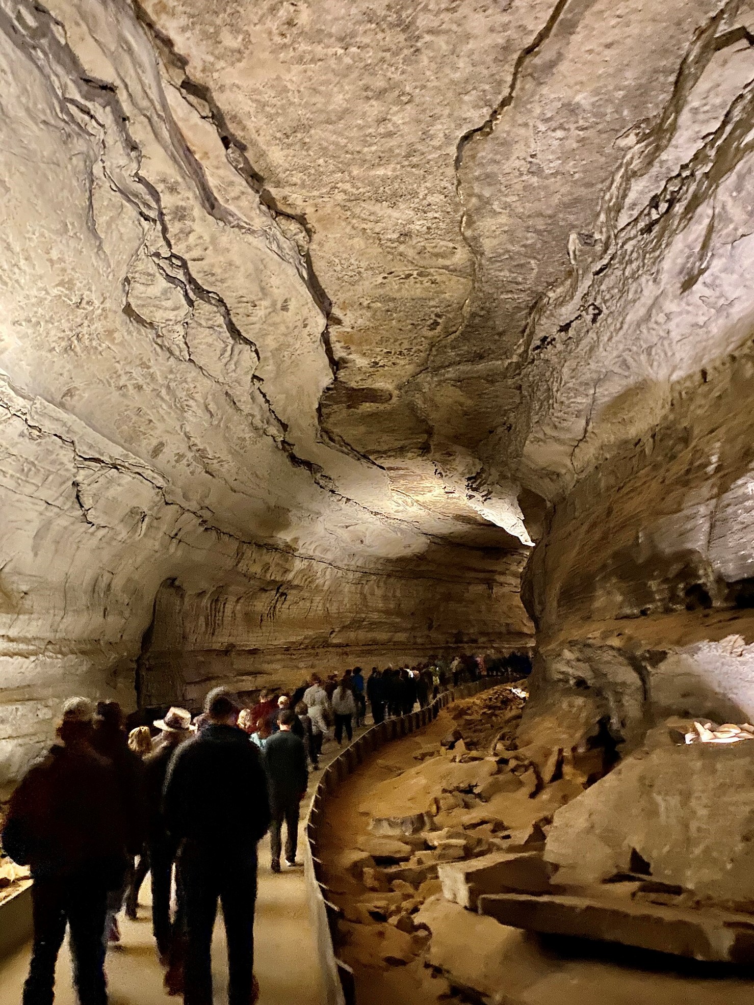
Gothic Avenue is one of the long linear tube-shaped chambers in the dry part of Mammoth Cave.
Credit: w_lemay, CC BY-SA 2.0, via Wikimedia Commons - However, in the lower sections of the cave or where the Big Clifty Sandstone roof is leaky or missing, formations like the Drapery Room, the Snowball Room, and Frozen Niagara form from moving water.
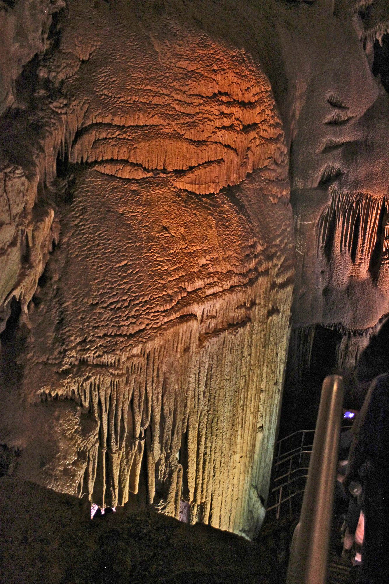
The Frozen Niagara formation at Mammoth Cave is calcium carbonate travertine flowstone along Mammoth Cave’s Kentucky Avenue. Many New York–inspired place names occur in this part of Mammoth Cave, named to lure New York tourists in the cave’s early days.
Credit: hakkun, CC BY-SA 3.0, via Wikimedia Commons
- Mammoth Cave has also recorded thousands of years of human history, with the spacious, dry cave serving as shelter for people and their agricultural products, as well as a refuge from danger.
- Indigenous Americans explored caves in the region as much as 5,000 years ago. They mined gypsum from the walls to use as white ceremonial pigment, drew pictographs on the walls, buried their dead and even left a pre-Columbian mummy trapped under a boulder.

2,100-year-old pictographs from the walls of Mammoth Cave.
Credit: NPS - The first European discovery of Mammoth Cave was recorded around 1797 as a hunter followed a wounded bear into a cave opening near the Green River then entered the huge recesses of a deep cave.
- The Historic Entrance was first surveyed and registered in 1798 for saltpeter mining from the huge quantities of ancient bat guano that had accumulated in the cave. Saltpeter is the principal ingredient of black gunpowder, and with a British trade blockade in place, domestic caves like Mammoth Cave were a key source of the explosive powder for Americans during the War of 1812, when enslaved people mined the saltpeter. The war ended in 1815, and the price of saltpeter crashed.
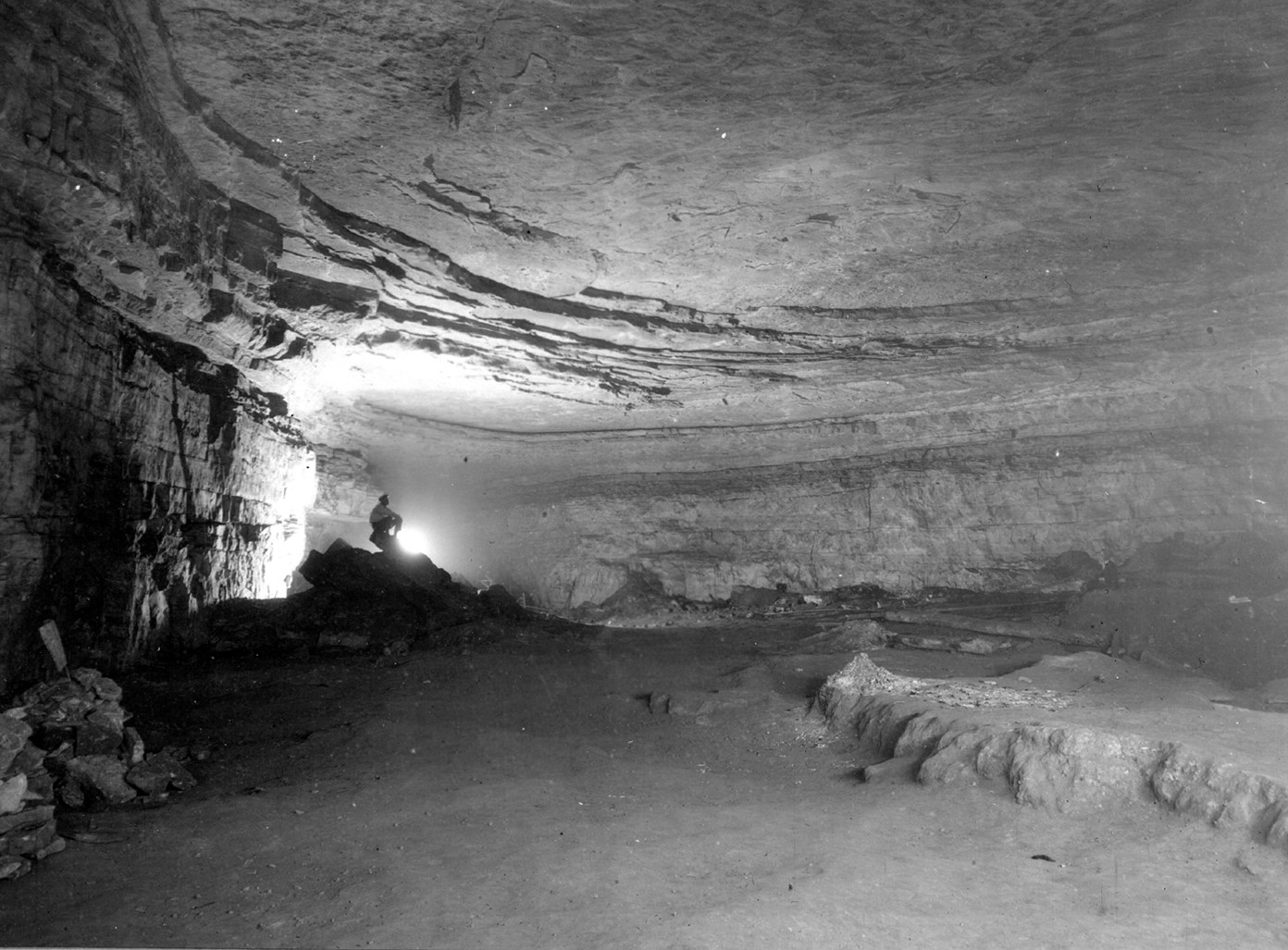
A 1925 photo of the Rotunda Room in Mammoth Cave National Park, Kentucky. The floor has been built up nearly eight feet by the mud left over after saltpeter processing.
Credit: Willis Thomas Lee, public domain, via Wikimedia Commons - Around 1816, the landowners began to operate the cave as a tourist attraction, using enslaved Black Americans as guides around 1830. Visitors would explore the inside of the cave with torches or oil lamps, leaving their names smoked onto the limestone.
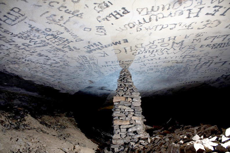
Historic signatures on the ceiling of Gothic Avenue of Mammoth Cave date to the 1830s.
Credit: NPS - From 1842 to 1843, a short-lived tuberculosis hospital called the Sick Room was set up in one of the corridors of the cave.
- Indigenous Americans explored caves in the region as much as 5,000 years ago. They mined gypsum from the walls to use as white ceremonial pigment, drew pictographs on the walls, buried their dead and even left a pre-Columbian mummy trapped under a boulder.
- A formerly enslaved man named Stephen Bishop was a notable guide that produced some of the first maps of the cave during the 1840s and 1850s, named some of its most interesting features, and guided famous stars of the Gilded Age through the caves.
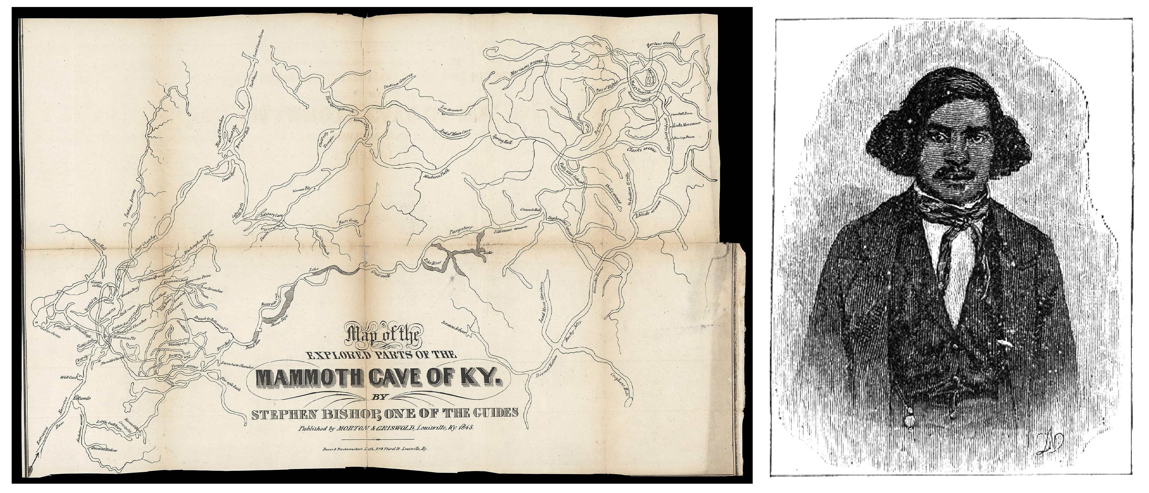
This map of Kentucky's Mammoth Cave was drawn from memory in 1842 by Stephen Bishop, a formerly enslaved man who worked as a guide at the cave. It was then published in 1845 by Morton & Griswold in Alexander Clark Bullitt's Rambles in the Mammoth Cave, During the Year 1844.
Credit: Stephen Bishop, public domain, via Wikimedia Commons- The first photos of Mammoth Cave were taken in 1866 by Charles Waldack using dangerous magnesium flash photography.
- In 1886, the Mammoth Cave Railroad connected Park City, Kentucky, to the historic Mammoth Cave Hotel, which operated until 1931.
- A lock and dam were constructed on the Green River in 1906 at Brownsville, Kentucky, making Mammoth Cave accessible by steamboat.
- In 1908, German visitor Max Kämper used surveying instruments to make a more accurate map that considered the topography around the cave, discovering several new entrances. His map was used until 1960.
- In 1924, the Mammoth Cave National Park Association began purchasing land around the cave, accumulating enough that the park was officially authorized in 1926. While some tracts of land were purchased, others were acquired by bitter eminent domain battles, with thousands of displaced. More than 600 parcels had been assembled by the time the land was declared a National Park.
- While the Mammoth–Flint Ridge Cave System is impressive, it is only one cave system out of many in this karst region of Kentucky.
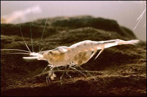
The Kentucky cave shrimp (Palaemonias ganteri) is an eyeless, troglobite shrimp that is endemic to the Mammoth Cave National Park region of central Kentucky. The shrimp's shell has no pigment, so the species is nearly transparent. It feeds mainly on sediments that are washed into the cave by the movement of groundwater.
Credit: U.S. Fish and Wildlife Service Headquarters, public domain, via Wikimedia Commons