Credit: Aurbina, public domain, via Wikimedia Commons
Easter Island has little to do with Easter—but new research shows it did once have a very impressive egg hunt.
More than a thousand years ago, Polynesians crossed thousands of miles of ocean to reach one of the most remote islands on the planet. They called it Rapa Nui and built a community there.
Three hundred years ago, a Dutch captain arrived on Easter day and gave the island its Western name.
Little did he know that, for centuries, the Rapa Nuans had worshipped migrating birds for their freedom to fly away to distant lands—and had practiced an important and sometimes deadly ceremony each year, upon the arrival of the sooty terns.
Young, fit Rapa Nuans would swim the shark-infested waters to Motu Nui, a rocky islet where the terns nested, to harvest an egg. They’d put it in a special headband carrier, then swim the watery gauntlet back to Rapa Nui, where they would climb a thousand-foot sea cliff, careful with every foot- and handhold not to break the egg.
The first egg hunter to arrive at the top, with his prize intact, would present it to an important elder in his village, who would be crowned Tangata-Manu, the bird man. His tribe would rule Rapa Nui for the next year.
Later, upon the bird man’s death, the islanders would carve a moai, one of their famous mega-statues, in his image.
This makes our Easter egg hunts look, well, like child’s play.
Background
Synopsis: Europeans “discovered” the Pacific island of Rapa Nui on Easter Day in 1722 so they called it Easter Island. One of Earth’s most remote islands, it is thousands of miles from other settlements. Aside from its name, it doesn’t have a lot in common with Western Easter traditions, however, it did have a Birdman culture with a very interesting story related to eggs.
- Rapa Nui, or Easter Island, is the easternmost Polynesian island and one of the most remote islands in the world.
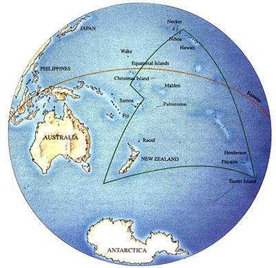
Map showing the location of Rapa Nui (Easter Island) within the Pacific Ocean at the southeastern corner (lower right) of the Polynesian Triangle.
Credit: Easter Island Statue Project- It is a six-hour flight (2,330 mi or 3,750 km) from Santiago, Chile, and an eight-hour flight from Tahiti (2,629 mi or 4,231 km).
- The closest inhabited island, with about 55 residents, is Pitcairn Island more than 1,280 mi (2,075 km) away.
- In 2022, Easter Island had a population of about 7,750, including Indigenous and European people.
- Easter Island consists of three extinct volcanoes that emerged from the sea during the Pleistocene Epoch about a million years ago and were sporadically active until the start of the Holocene Epoch about 11,000 years ago.
- The island formed 224 mi (360 km) east of the East Pacific Rise spreading center along the Sala y Gómez Ridge on the Nazca tectonic plate.
- It rises from the seafloor more than 9,000 ft (2,750 m) below, and its highest point, Terevaka, rises 1,663 ft (507 m) above sea level.
- The three extinct volcanoes produced a 63 mi2 (163 km2) triangular island of rolling hills punctuated with occasional exposed volcanic cones.
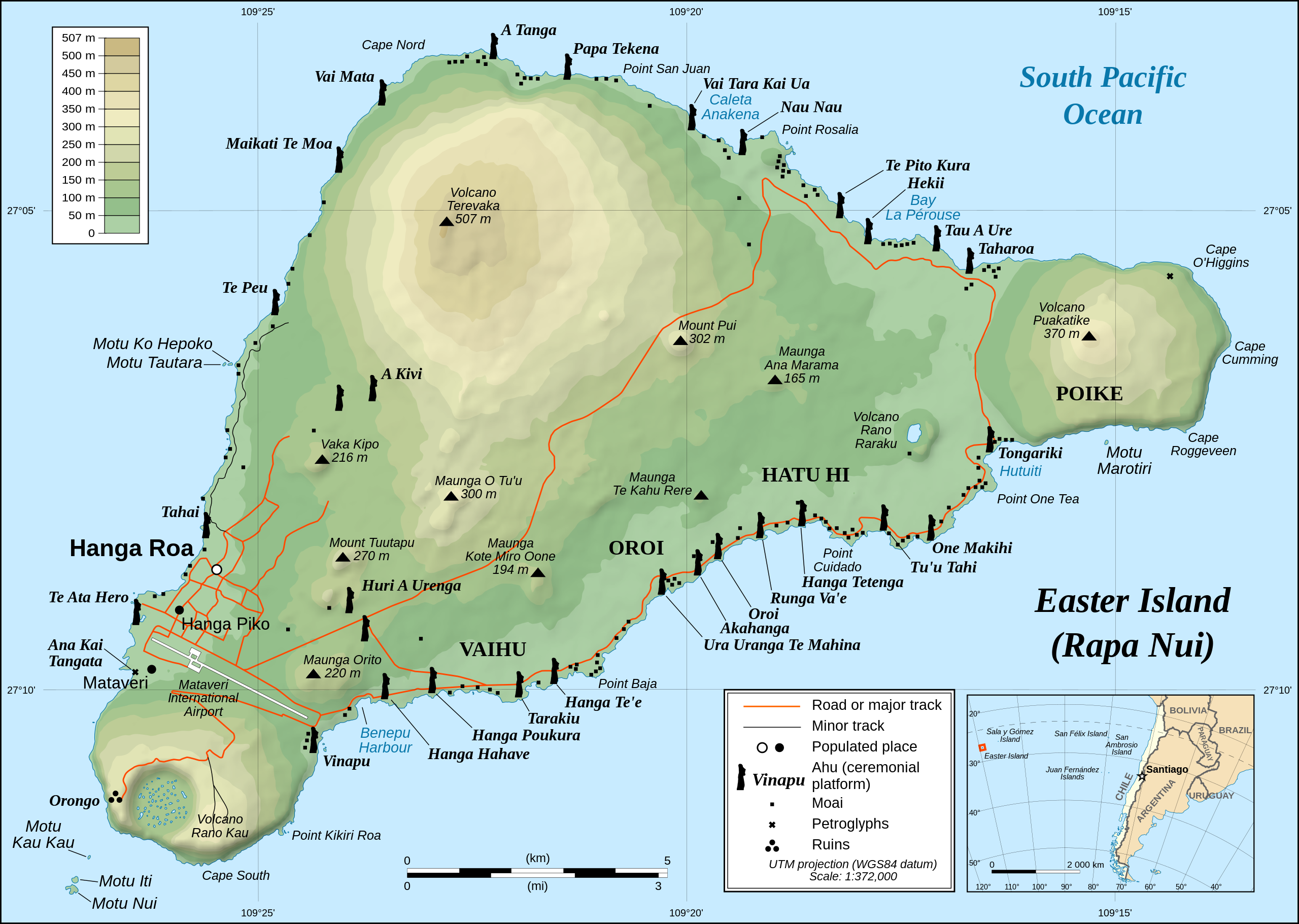
Detailed topographic map of Easter Island showing the location of moai statues and ceremonial platforms. The island is 14 miles (23 kilometers) long by 7 miles (11 kilometers) wide.
Credit: Eric Gaba (Sting), translated by Bamse, via Wikimedia Commons - The islanders rely on precipitation that recharges two island lakes as their only source of fresh water.
- The steep sided island lacks reefs that might form harbors but has a few sandy beaches where canoes from thousands of miles away could land.
- Easter island was “discovered” by Dutch navigator Jacob Roggeveen on April 5, 1722, although Polynesians inhabited the island by 1100 CE (and possibly centuries earlier).
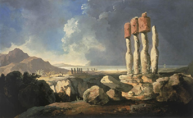
Moai on Easter Island, a painting by William Hodges, 1775–76
Credit: William Hodges, Teilnehmer an der Expidition von James Cook, public domain, via Wikimedia Commons- Nearly 50 years later, in 1770, two Spanish ships visited the island, and, then, in 1774, British Captain James Cook arrived. Both expeditions documented huge statues around the island.
- The first detailed European maps of Rapa Nui were created in 1786 by a French expedition.
- In the 1860’s, Peruvian slave traders arrived, decimating the population.
- Smallpox and tuberculosis decreased the population further, and, in just a decade, the island’s population decreased by 97% to just 111 people.
- In 1888, Chile annexed the island, and through the early 1900’s the island was operated as a sheep farm.
- In 1966, the islanders were given Chilean citizenship.
- The airport was constructed in 1987, opening up the tourist industry that sustains the island today. It also serves as an emergency landing strip for NASA.
- With its rich archaeological and anthropological record, the island was named a UNESCO World Heritage Site in 1995, and much of its land is designated as the Rapa Nui National Park.
- Although it previously had forests of broad leaf trees and palms, today the island is covered with grasses and shrubs.
- The Indigenous people cleared forests for crops, using some trees to build seafaring canoes until there were no more trees, then they were marooned on the remote island until Europeans arrived.
- Some experts use the island as a metaphor for our planet with overuse of resources and stranding of the population resulting in collapse of the civilization.
- Today, a new eucalyptus forest has been established at the island’s center.
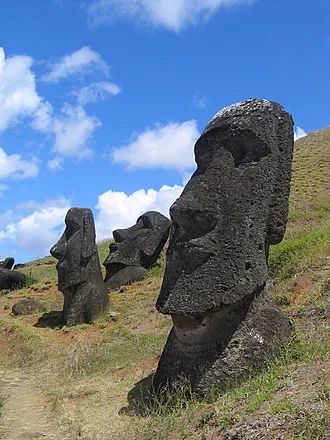
- Rapa Nui is most famous for the hundreds of large carved statues known as moai that are distributed along its shores and ridges.
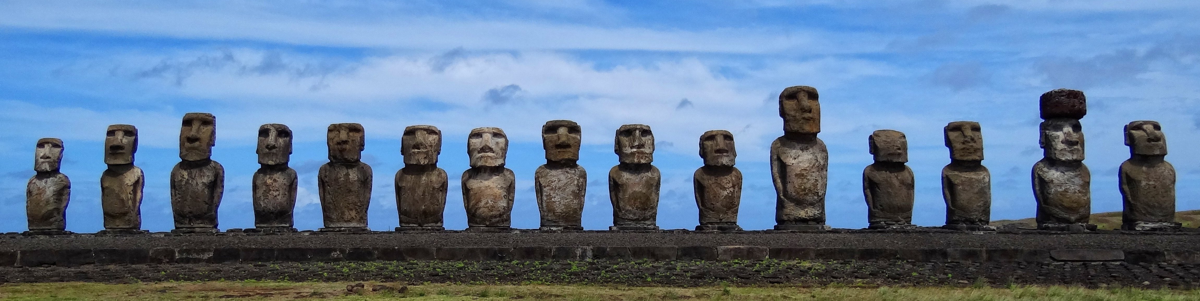
The fifteen standing moai of Ahu Tongariki, Easter Island.
Credit: Bjørn Christian Tørrissenderivative work: George Tsiagalakis, via Wikimedia Commons- Starting around 1100 CE the moai were carved from tuff outcrops in a volcanic crater called Rano Raraku to represent ancestors who were chiefs, the “living faces of the past.”
- Crowns of red volcanic scoria from Puna Pao adorned the heads of these statues that can be up to 30 ft tall and weigh 60 tons.
- The origin of the moai can be traced to the Birdman culture that arose on Rapa Nui.
- Islanders revered birds who had the freedom to fly across the ocean.
- An annual competition occurred to collect the first egg of a sooty tern from their nesting site on the nearby islets of Motu Nui and Motu Iti—it was a difficult and sometimes deadly egg hunt.
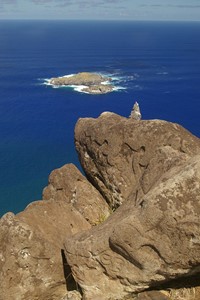
Petroglyphs on rocks at Orongo show the creator, Make-Make, near the base and two birdmen, Tangata-Manu, higher up on the cliff. Motu Nui and Motu Iti can be seen in the distance.
Credit: Rivi, via Wikimedia Commons - The individual who acquired the first egg swam back to Rapa Nui through shark-infested waters, climbed a 1,000 ft sea cliff to the village of Orongo, and presented the unscathed egg carried in a reed headband to their sponsor (an important village elder).
- The sponsor would be named the Tangata-Manu (birdman). He would shave his head and go into seclusion for a year as the representative of the creator on Earth, being fed by an attendant and allowing his hair and fingernails to grow all year. His tribe would rule Rapa Nui for the full year.
- Later, upon their deaths, these powerful chieftains would be honored with a new moai statue carved over the course of a year and erected facing toward the center of the island to protect its inhabitants.
- Studies show the moai were probably rolled upright on logs from the quarry at Rano Raraku to their destination.
- The heads and shoulders of the moai were exposed above ground, but the rest of the highly decorated statues were buried.
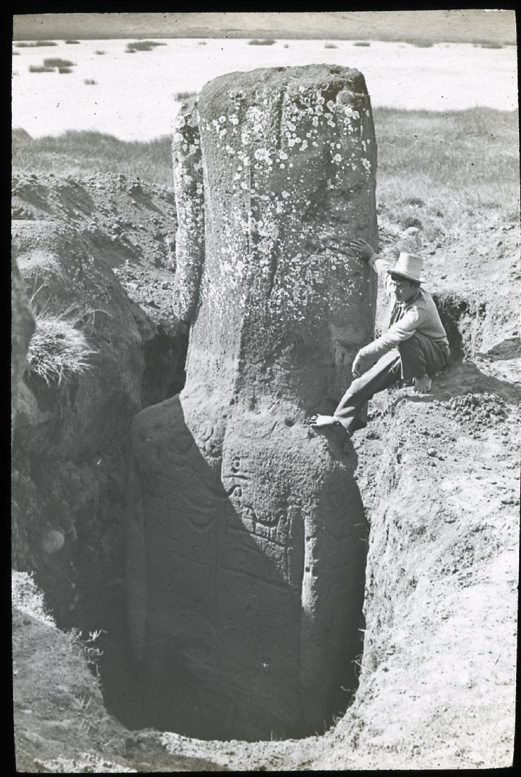
Photograph from the British Museum, taken between 1914 and 1915, of a view of the back of a moai (figure carving) with petroglyph carvings, including a double loop and several canoe shapes. The sculpture is standing upright in the ground, partially excavated. A South American man is sitting on the ground, with one bare foot on the shoulder of the sculpture on Rano Raraku, Easter Island.
Credit: Unknown author, public domain, via Wikimedia Commons
- Strife attributed to limited island resources led to civil war among the Indigenous clans in the late 1700’s (after first European contact) and destruction of some of the sacred and protective moai by warring groups.