Credit: USGS
Compasses point north. Until one day, they’ll all point south—as they have before.
In 1905, a French geologist discovered a lava field with some very strange properties. Iron within it was magnetized in reverse. What should have been north was south.
After much pondering, he realized this could only be possible if Earth’s magnetic poles were reversed at the time the lava was flowing. When it solidified, it preserved that reversed magnetic orientation.
It took 50 years for other scientists to accept the idea that Earth could change its polarity. But when they did, a frenzy of research began to try to document the phenomenon.
First, they looked for more places where a reversed magnetic field was memorialized in iron compounds.
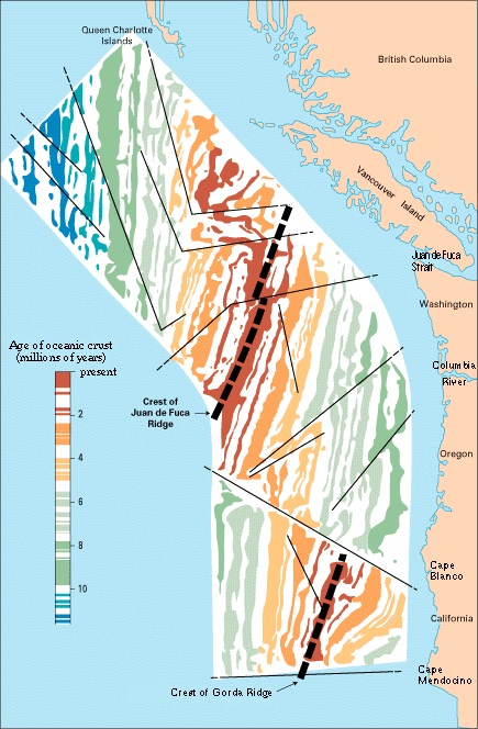
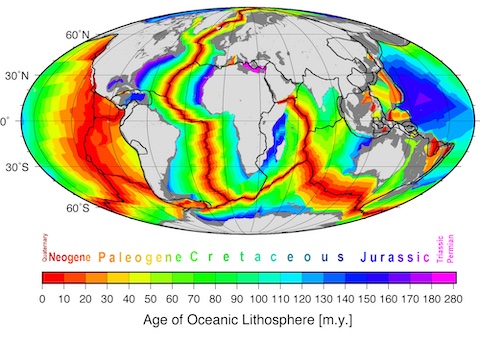
They found them along spreading ridges in the Atlantic, where tectonic plates pull apart and new iron-rich rock is pushed up, producing new crust for the planet.
In 1959, they mapped alternating stripes of reversed magnetic orientation in several places along the Atlantic ridge, then dated each stripe of rock.
To their surprise, they discovered that Earth had reversed polarity hundreds of times, with episodes lasting tens of thousands to millions of years before reversing again.
They also realized that Earth’s magnetic poles are always on the move, sometimes without making a full reversal.
We’ll talk more about the mess this could make on another EarthDate.
Background
Synopsis: Stripes of opposing magnetic polarity discovered on the seafloor in the middle of the 20th century led to a couple of amazing scientific realizations: The seafloor was constantly being generated by basalt emplacement along spreading ridges, and like a tape recorder, iron minerals in the basalt had been recording reversals in the orientation of Earth’s magnetic field over millions of years. Hundreds of magnetic episodes are now documented. Some lasted thousands of years, while others lasted tens of millions of years. The most recent reversal followed a couple of “failed attempts” over the course of 22,000 years before flipping to today’s orientation 773,000 years ago. Understanding past events like this flip is critical to our modern civilization.
- Earth’s magnetic field is a dipole, meaning it has one pole where the magnetic field emanates from Earth (near today’s South Geographical Pole) and one pole where the field dives back into Earth (near today’s North Geographical Pole).
- The compass was invented during the Chinese Han Dynasty around 200 BCE to measure the orientation of Earth’s magnetic field. The north arrow of a compass aligns with the magnetic field as it flows northward.
- In the early 1830’s, Carl Friedrich Gauss invented the first magnetometer that could measure the strength of a magnetic field.
- Strength and orientation of a magnetic field describe its magnetic dipole moment, critical to the study of Earth’s dynamic magnetic field.
- Some iron-rich minerals orient their atoms in alignment with prevailing magnetic fields.
- In 1905, geophysicist Bernard Brunhes noticed that certain volcanic rocks in south central France were magnetized in the direction opposite of the local magnetic field.
- Brunhes suggested this could only happen if Earth’s magnetic field had been reversed at the time of the lava flow. It took 50 years for other scientists to accept the idea that the magnetic field could flip so that it emanated from Earth in the north and dove back into Earth in the south.
- In the 1920’s, Motonori Matuyama added the observation that all the known rocks exhibiting reversed polarity were early Pleistocene or older.
- In the 1950’s and 1960’s, several directions of research converged into earthshaking results.
- Radiometric dating of reversed intervals in volcanics and deep-sea core resulted in the first magnetic polarity timescale in 1959.
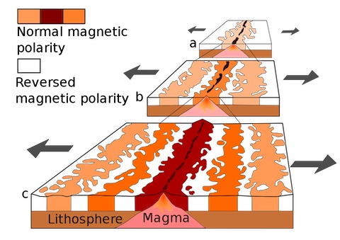
- Magnetometer data collected by research vessels and plotted on maps showed patterns of magnetic stripes of opposing polarity preserved in seafloor basalts.
- Magnetic profiles from the Atlantic’s Reykjanes Ridge were symmetric on either side of the ridge and matched the symmetric patterns of profiles across the Pacific-Antarctic Ridge as well as other spreading ridges.
- Bringing these observations together, scientists realized that seafloor was constantly generated at spreading ridges, and like a tape recorder, basalt emplacement was recording reversals in the magnetic field over millions of years.
- Acknowledgment of seafloor spreading led to the overarching theory of plate tectonics but also made it clear that Brunhes had been correct in 1905: Earth’s magnetic field has a history of flip-flops that is literally set in stone.
Credit: Chmee2, public domain, via Wikimedia Commons
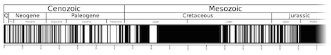
- As a matter of fact, in the past 83 million years there have been 183 reversals ranging in length from 10,000 years to around 5 million years.
- Before that, there was a very long period of magnetic “quiet” that started 121 million years ago and lasted 38 million years called the Cretaceous Normal Superchron. It had the same “normal” polarity as today for the whole time, but recent research shows it was not completely quiet, with some fluctuations midway through the episode.
- Although researchers have tried to apply statistics to the polarity record, reversals appear to have random lengths.
- The seafloor magnetic polarity record becomes increasingly difficult to follow with age but extends back to the early Triassic, 250 million years ago.
Credit: user Anomie, https://en.wikipedia.org/wiki/File:Geomagnetic_polarity_0-169_Ma.svg
- Earth’s geodynamo generates our protective magnetosphere (ED-003 Life on a Giant Magnet) as electric currents from the convection of Earth’s molten outer core generate the magnetic field (ED-006 Geodynamo).
- Variations in the flow of Earth’s liquid outer core produce a complicated magnetic field pattern that changes over time.
- Today, Earth’s magnetic poles are fairly coincident with its geographical (rotational) poles (ED-122 Triple North Pole).
- Our North Magnetic Pole is dynamic, migrating as much as 500 ft (150 m) per day (ED-123 The Wandering Pole) from Canada toward Siberia. South Magnetic Pole variation is even more complex.
- With the North Magnetic Pole moving more than 600 mi (1,000 km) in the past 30 years, it should be no surprise that at times during geological history the magnetic field has wandered far enough from the rotational poles (40–45°) for its journey to be called an excursion.
- During excursions, the magnetic field intensity may decrease to just 5 to 10 percent of its normal intensity.
- After excursions, the magnetic field may return to its prior orientation, or it may flip polarity. If it flips, it is called a reversal.
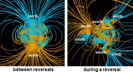
- Transitional periods between polarity episodes have been estimated to range in duration from hundreds to tens of thousands of years.
- During transitions, Earth’s magnetic field is likely to become more complex, possibly developing multiple poles.
- Some researchers suggest that excursions occur when iron molecules in the liquid outer core switch direction but that reversals occur only once the solid inner core also switches direction and is in alignment with the outer core. Others believe that the dynamo is simply inherently disorganized, making it unstable.
Credit: NASA
- The most recent reversal occurred nearly 800,000 years ago at the start of the middle Pleistocene Chibanian Age.
- It is called the Brunhes-Matuyama reversal after the first scientists to identify and propose an age for Earth’s most recent magnetic reversal.
- The Matuyama Chron is the period before the reversal, while the Brunhes Chron is the period since the reversal, continuing until today.
- Recent comprehensive studies of magnetized lava flows correlated to sediment cores and ice records show a complicated history of the transition, which took 22,000 years.
- 795,000 years ago, sediments and ice core data indicate Earth’s south-directed field weakened into an excursion then reintensified back to its original orientation.
- Then, 784,000 years ago, sediments show the field weakened again and began a chaotic excursion period with 10,000 years of variable directions.
- Finally, after two “failed attempts” at reversal, 773,000 years ago the field flipped 180 degrees to today’s “normal,” northward-directed orientation, regaining its full intensity.
- Geological records don’t provide many details of the consequences of the Brunhes-Matuyama reversal for the early Pleistocene Earth.
- The transition occurred during the Lower Paleolithic, so hominins lived through it, but anthropological records of the transition are sparse.
- Since the magnetosphere protects life on Earth from cosmic and solar radiation, understanding the machinations of the geodynamo is essential to us. The magnetosphere also protects modern technology, including our satellites and communication systems.
- Studies of a more recent excursion around 42,000 years ago provide some clues, and we will talk about that in the next EarthDate episode.
Credit: NOAA