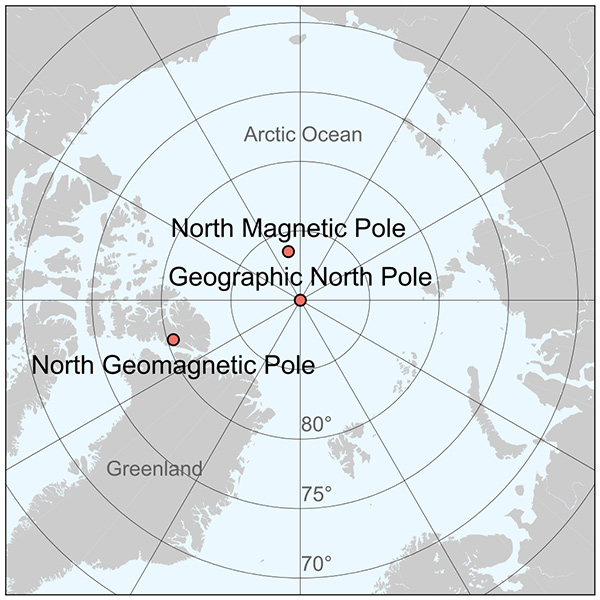
It might surprise you to know there are actually three North Poles: the geographic, the magnetic, and the geomagnetic.
The one we most commonly think about is the Geographic North Pole—the tip of the axis that the globe spins around. It’s in the middle of the Arctic Sea, on pack ice, above more than 2 miles of water.
During the summer, when the pole is tilted toward the sun, it’s 24-hour daylight. In the fall, the sun finally sets—once, and only once, per year. That brings on 6 months of night, until springtime, when the once-annual sunrise starts another 6 months of day.
The North Magnetic Pole is slightly to the south. This is where Earth’s magnetic field, which springs out of the ground at the South Magnetic Pole, dives back into the ground.
Its exact location, however, is constantly changing, because Earth’s magnetic field is always changing.
Today, magnetic north is moving about 34 miles a year, gradually traveling toward Siberia.
Finally, there’s the North Geomagnetic Pole—the northern axis of the magnetosphere, the magnetic shield that protects us from solar winds.
If you imagine the magnetosphere as a ball around a bar magnet, with the bar running through Earth, this pole would be the positive end. It’s currently 700 miles south of the Geographic North Pole but also always traveling.
With three dark places to look in the dead of winter, and two of them moving, it’s a wonder Santa ever makes it home.
Background
Synopsis: Believe it or not, Earth has three North Poles: one whose rotational axis intersects the surface; one at the point where compass needles dive vertically toward Earth; and one where the theoretical bar magnet, or dipole, that supports our protective magnetosphere comes to Earth’s surface in models.
- The Geographic North Pole is the northern end of Earth’s rotational axis—its “spin” axis.
- Also known as “true north,” it represents the “north” we see on most maps.
- Lines of latitude (parallels) and longitude (meridians) are referenced to the Geographic North and South Poles.
- Although this is the pole where Santa’s Workshop is said to be located, the crafty elf has ensured that efforts to mark this pole with a monument are futile, since it is located where the Arctic Ocean is more than 13,400 ft (4,080 m) deep, below drifting pack ice.
- Only one sunrise and one sunset per year occur at this pole: full-time sunlight in the summer gives way to total darkness in the winter.
- Earth’s rotational axis wobbles like a top, or precesses, every 26,000 years. For centuries, the north rotational axis has pointed toward Polaris, enabling ancient explorers to use this “North Star” for navigation.
- In 13,000 years’ time, the wobble will cause Earth’s spin axis to shift across the heavens to point at the star Vega instead.
- In the 1800s and early 1900s, a number of explorers attempted to reach the North Pole by sea, air, and land, but confirmation of success was difficult and many expeditions ended in disaster.
- Compasses all over Earth point toward the North Magnetic Pole, which is the location on the surface where compass needles will actually point vertically downward toward Earth.
- The difference between geographic north and magnetic north is called declination, which varies up to 20 degrees depending on your location on Earth.
- Those who use compasses must adjust their paths by the local declination to avoid going off course.
- The magnetic field is generated by Earth’s dynamic liquid outer core, so magnetic north is constantly on the move.
- The National Oceanic and Atmospheric Administration (NOAA) and the British Geological Survey usually update the World Magnetic Model (WMM) every 5 years.
- In late 2018, however, the model was updated ahead of schedule because magnetic north is moving more quickly than usual: about 34 mi/yr (55 km/yr) from Canada toward Siberia.
- We’ll talk about this wandering pole in another EarthDate episode.
- The North Geomagnetic Pole is the northern axis of Earth’s magnetosphere, which protects us from cosmic and solar radiation and is also tied to variability in Earth’s outer core.
- If you think of Earth as a dipole—a simple bar magnet—this pole represents the best-fitting theoretical expression of the northernmost end of the magnet.
- Geomagnetic north is not a specific point on Earth’s surface; rather, it measures a few kilometers across Earth’s surface and shifts location; it is currently located on Canada’s Ellesmere Island, east of magnetic north’s path and about 680 mi (1,100 km) from Earth’s northern spin axis. It has moved slowly northeastward in the past century.
- Earth’s magnetosphere is not symmetric: a line from the north end of the bar magnet to the south end does not actually pass through the center of Earth, so the hypothetical bar magnet is skewed compared to the shape of the globe.
- Earth also has three South Poles.
- The Geographic South Pole is marked at an elevation of 9,300 ft (2,830 m), with an ice thickness of 8,850 ft (2,700 m). At present, this southern rotational axis doesn’t point at a particular star, so there is no “South Star” for navigators to use.
- Magnetic south moves slower than magnetic north, at about 8 mi/yr (13 km/yr) toward the northwest. It is currently about 1,780 mi (2,850 km) from the Geographic South Pole.
- Geomagnetic south is located near Russia’s Antarctic Vostok Station.