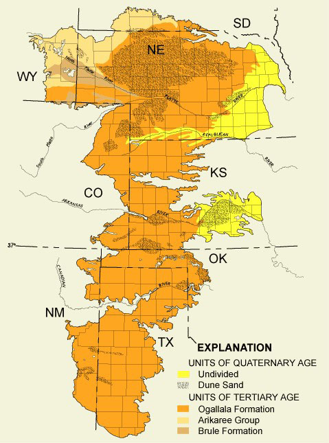
There’s one source that provides almost a third of the water for all US agriculture. It’s called the Ogallala aquifer, stretching under the Great Plains from South Dakota to northern Texas.
Once considered inexhaustible, we now understand its limits.
For the first settlers in the Great Plains, water was scarce and farming was difficult…
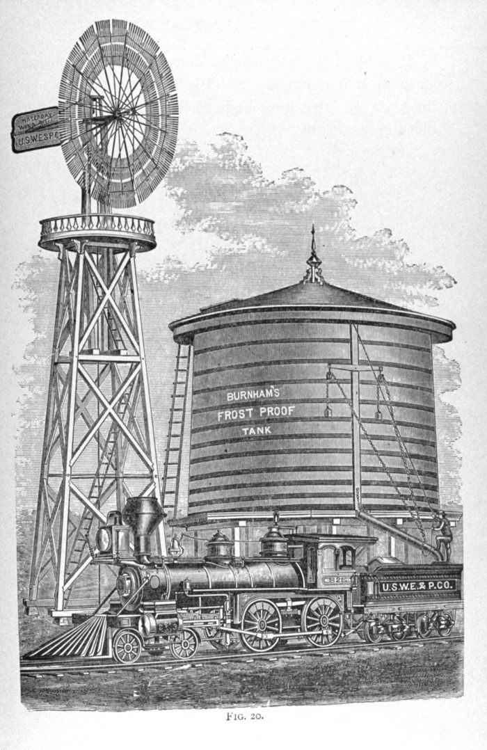
Until the 1850s, when they began to use windmills to pump up groundwater from the aquifer. Suddenly they had all they needed and an agricultural boom was on.
Farmers and growing towns pumped water with abandon for a century, thinking it was being naturally recharged.
And it is, but so slowly that even that early pumping had begun to deplete it.
The Ogallala, it turns out, is what’s called fossil water. It was filled by the melt of continental ice sheets during Pleistocene ice ages. Some hydrologists think that took six million years.
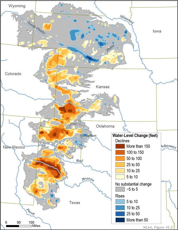
But in the shallowest and thinnest parts of the aquifer, like in Texas and Kansas, its level has already fallen 100 to 200 feet. In a few places, it’s been completely drained.
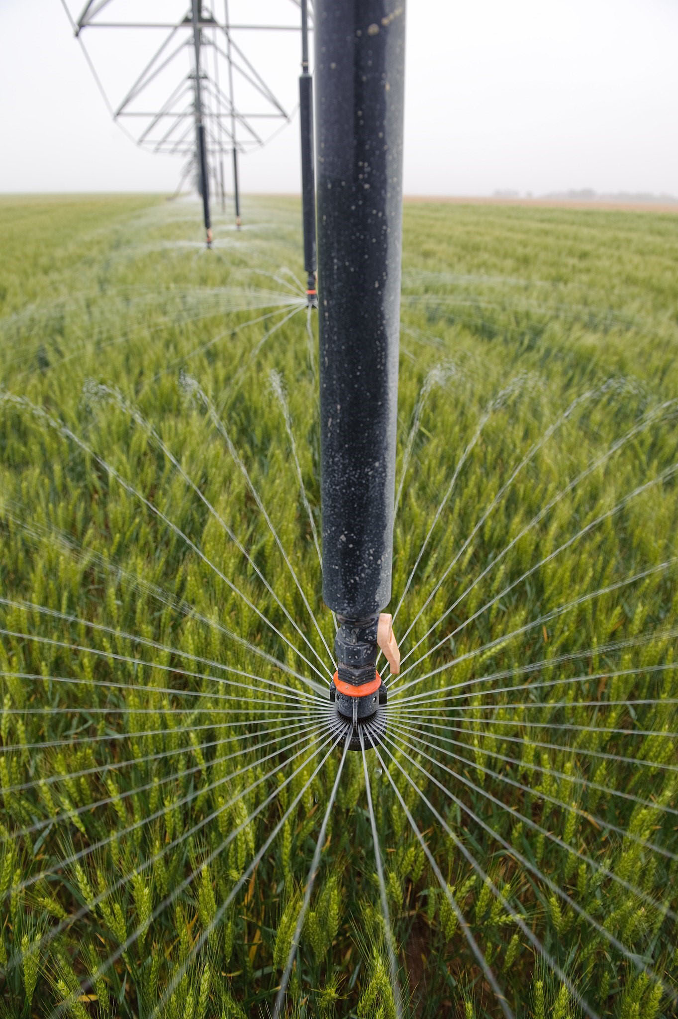
This has spurred many states to regulate the use of the aquifer and many farmers to adopt more efficient irrigation systems and water conservation farming techniques.
We’ll need more of all three because we rely on the Ogallala for much of our water and food— and, hopefully, will be able to do so in the future.
Background
Synopsis: The Ogallala aquifer is the water source for most of the crops in the High Plains region of the United States. One of the largest freshwater accumulations in the world, this underappreciated aquifer provides 30% of the groundwater used for irrigation in the United States. With around 10% of its ancient water already produced, some sections of the aquifer are rapidly depleting. Higher efficiency agricultural practices are helping to buy time, but some portions of the aquifer are being “managed to depletion,” contributing to an uncertain future.
- The principal aquifer of the America’s High Plains is the Ogallala aquifer, which underlies eight states, extending about 174,000 sq mi (450,000 sq km) from South Dakota to North Texas.
- The High Plains aquifer system includes the Ogallala formation as well as other less extensive peripheral aquifers that may be lumped together and referred to as the Ogallala aquifer.
- The Ogallala formation is composed of a wide range of sediment types, from gravels to sands, silts, and clays, sourced from the Rocky Mountain region to the west during the Miocene and Pliocene Epochs.
- The Laramide uplift of the Rocky Mountains lasted from about 80 million years ago until about 35 million years ago.
- Intensive erosion by rivers in the newly formed mountains created deep valleys that cut down into Cretaceous rocks (145–66 million years old) in Nebraska.
- Progressively older rocks were excavated toward the south, extending into Permian units (more than 250 million years old) in Texas.
- Miocene uplift of the Colorado Plateau produced abundant sediments that filled and overtopped these valleys as broad overlapping alluvial fans and dune fields of the Ogallala, ranging up to 900 ft (275 m) at its thickest point.
- Grass seeds and ash beds are typically used to date horizons in the Ogallala formation.
- The Ogallala aquifer was saturated with fossil water during the ice ages of the Pleistocene.
- Some estimates suggest it took as long as six million years for the water to percolate into the pore space in the rocks.
- Erosion along its western edge disconnected the Ogallala from any future Rocky Mountain recharge.
- Finally, it was partially covered by Pleistocene fine-grained windblown glacial deposits known as loess.
- As pioneers moved west, they struggled to make a living in harsh climate of the High Plains until they began to employ pumps to produce water.
- The Halladay wood bladed wind pump was first introduced in 1854 to produce water for High Plains irrigation.
- By 1870, steel fan blades replaced wood for more efficient irrigation water withdrawal.
- These windmills also became the most widely used for railway water stations in the region.
- Dust Bowl events in the 1930s (ED155, ED156, and ED157) devastated the region.
- In the 1940s, the introduction of gas-powered groundwater pumping and irrigation systems provided high discharge access to this remarkable reservoir.
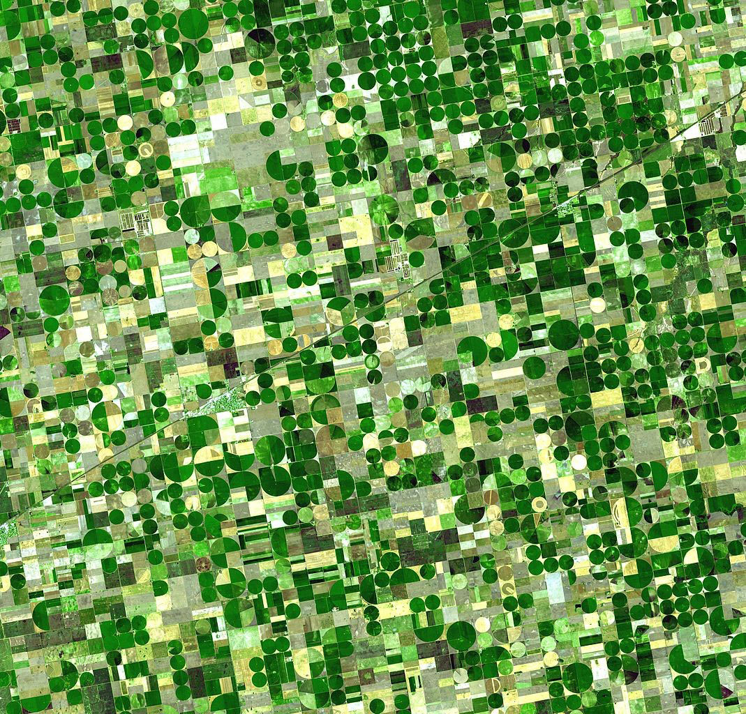
- As more wells were drilled and center-pivot irrigation was introduced in the 1940s and 1950s, green circles of lush vegetation replaced prairie land on the High Plains.
- “Amber waves of grain” covered the High Plains creating the prosperous grain belt—or breadbasket—that produces about 25% of the crops Americans rely upon for much of our food and animal feed today.
- Ogallala irrigation water supports $35 billion in crops every year.
- The Ogallala aquifer holds enough water to cover all fifty United States in 1.5 ft of water. That’s three billion acre-feet or one quadrillion gallons (a million billion gallons or 1,000,000,000,000,000 gallons), about the volume of Lake Huron.
- Since pumping began, the aquifer has produced about 85% of the volume of Lake Erie, more than 300 million acre-feet (about 10% of its original volume).
- Two-thirds of Ogallala groundwater lies below Nebraska, with another 20% in Texas and Kansas.
- Groundwater flows from the semiarid recharge area in the west toward the east at about one foot per day.
- Recharge is limited to less than a millimeter per year of rain or recharge in parts of Texas and up to 6 in (15 cm) of rain or recharge in Kansas, averaging less than 1 in (2.5 cm) in the region.
- The water table is 400 ft (120 m) below the land surface in the north and as shallow as 100 ft (31 m) deep in the south, but it is dropping as much as five feet per year in some areas—and some parts of the aquifer are completely drained.
- Aquifers that are depleted have air in their pores instead of water.
- The process of depleting an aquifer is known as mining, which may result in irreversible impaction of the reservoir as replacement of incompressible water with compressible air may cause crushing of pore space and permeability, limiting future recharge.
- Today more than 200,000 wells produce water from the eight-state area, withdrawing water at 3 to 50 times the recharge rate for the aquifer’s semiarid recharge zone.
- In the 1950s, farmers assumed Ogallala groundwater was bottomless.
- Since then, the water table has dropped 100–200 ft in some areas making it clear that the aquifer is being depleted, especially where it is thinner in the South.
- Additionally, fertilizer and industrial chemicals have caused pollution of the Ogallala aquifer in some areas.
- In response to the water crisis, farmers have embraced more efficient use of water in agriculture.
- Tilling has been reduced to help retain existing soil moisture.
- Precision irrigation equipment applies water closer to the ground to avoid evaporation.
- Crop water needs and local weather are monitored remotely to avoid wasting irrigation water.
- States monitor water withdrawal using meters and limit pumping where warranted, although laws, regulations and policies are inconsistent from state to state.
- Some farmers are returning to nonirrigated dryland farming, to become independent of aquifer limitations.
- As water production continues to feed America and the world, policymakers and residents of the region ponder management of the depletion of a remarkable resource as well as an uncertain future.