Mt. Everest, at just over 29,000 feet above sea level, may be the highest point on Earth’s surface—but what’s the lowest?
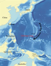
Well, the deepest part of the deep sea is the Mariana Trench in the Pacific, off the island of Guam, about halfway between Japan and Australia.
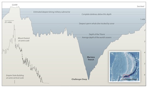
It’s five times as long as the Grand Canyon and more than a mile deeper than Everest is tall.
And the deepest point in the trench is called Challenger Deep, nearly 36,000 feet below sea level. It’s named after the Challenger 1 and 2 exploration ships which, in the 1870’s and 1950’s, first measured Earth’s lowest point using iron weights and very, very long metal wires.
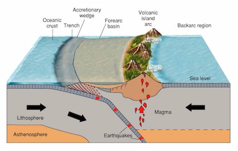
Deep sea trenches like the Mariana form along tectonic plate boundaries, where plates collide and one is forced under the other, pushing down the surface of Earth in what’s called a subduction zone.
No sunlight can reach this deep, so the trench is in absolute darkness. Life and the food web are very sparse, with some creatures relying on chemosynthesis—feeding on methane or sulfur.
The water is near freezing, and water pressure at the bottom of Challenger Deep is 1000 times that at sea level—enough to crush the bones of humans.
Of course, that didn’t stop humans from wanting to explore it. Who they were, how they did it, and what they found, we’ll talk about on another EarthDate.
Background
Synopsis: The Pacific, Earth’s deepest ocean, is rimmed by the infamous “Ring of Fire”—a series of tectonic plate boundaries. One of these boundaries forms the deepest trench in the Pacific: the Mariana Trench. Its deepest section, Challenger Deep, is more than a mile deeper (below sea level) than Mount Everest is tall (above sea level).
- Deep trenches form where plates of oceanic crust converge and one plate is forced to descend downward below the other into the mantle—this is called a subduction zone. As the descending slab melts, it powers volcanic activity on the overlying plate.
- In the western Pacific, both the Pacific Plate and the Philippine Plate are moving to the northwest, but the Pacific plate is moving about an inch (2.5 cm) a year faster.
- Over millions of years, this differential movement has caused the Mariana Trench to form where the Pacific Plate dives below the smaller Philippine Plate.
- The Mariana (or Marianas) Trench is Earth’s deepest trench; Challenger Deep within sets the record for the deepest point on the Earth’s surface.
- The crescent-shaped trench is five times the length of the Grand Canyon—more than 1580 mi (2542 km) long—but averages only 43 mi (69 km) wide.
- The weight of water on the floor of the trench results in pressures of more than 8 tons per square inch, or 1000 times the pressure at sea level.
- The highest and lowest points on Earth were both identified in the late 1800s.
- Mount Everest, standing at 29,029 ft (5.50 mi. 8,848 m) tall, was named by the Royal Geographical Society in 1865. It was first summited in 1953 by Tenzing Norgay and Sir Edmund Hillary. More than 5000 people have since summited the peak.
- In 1875, Challenger Deep was first sounded during the HMS Challenger expedition of 1872 to 1876, which recorded the trench as 4,475 fathoms (26,850 ft; 8,184 m) by measuring using a hemp rope with iron weights.
- In 1951, the HMS Challenger II returned to investigate the deep, this time recording a depth of 35,640 ft (10,863 m) using scrap iron tied to a taut wire. This made Challenger Deep ~7000 ft (1.3 mi, 2133 m) deeper than Mount Everest is tall.
- Challenger Deep was named after these two vessels. During the 1800s, oceanographers designated areas with a water depth of more than 3000 fathoms (18,000 ft; 5,486 m) as “deeps.”
- The second deepest point in the ocean wasn’t documented until 122 years after Challenger Deep was discovered. In 1997, oceanographers mapped Sirena Deep at 35,462 ft (10,809 m). It is 124 mi (200 km) northeast of Challenger Deep and also located within the Mariana Trench.
- The maximum depth of such deep ocean trenches is difficult to measure precisely.
- Oceanographers typically use sonar to measure depth, but the speed of sound waves through water is influenced by variations in water density driven by changes in temperature, pressure, and salinity in multiple shifting water layers. Even changes in surface barometric pressure can have an effect on results.
- Though scientists may model the layers to improve the depth analysis, most measurements are recognized to carry an error bar of 70–165 ft (10–25 m).
- The deepest depth ever measured in the Challenger Deep is 36,070 ft (6.83 mi, 10,994 m), recorded using sonar from the surface by NOAA in 2010.
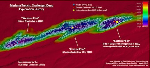
- Thanks to recent surveys obtained as part of the 2019 Five Deeps Expedition, we now know that the Challenger Deep consists of three en echelon basins ranging from 4 to 6 mi (6 to 10 km) long and 1.2 mi (2 km) wide.
- All three are deeper than 33,800 ft (10,300 m), with the central pool being the shallowest and the eastern pool being the deepest at 35,843 ft (10,925 m).
- These narrow steep-sided tears in the seafloor contain boulder fields within fine-grained deep-sea sediments.
- Subduction zones are prone to earthquakes that drive slope instability as well as submarine-gravity-driven sediment flows.