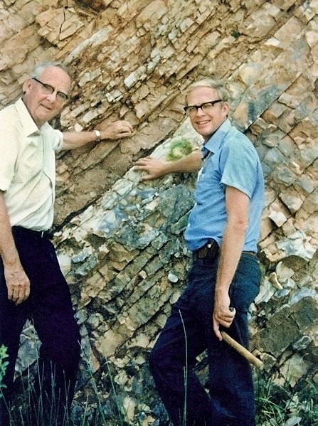
Luis and Walter Alvarez at the Cretaceous–Paleogene Boundary in Gubbio, Italy, 1981. Credit: U.S. Government (Lawrence Berkeley National Laboratory) (public domain), via Wikimedia Commons
Sixty-six million years ago, three-fourths of all species on Earth died out. Scientists knew it. But they didn’t know why.
Then, in the 1970’s, geologist Walter Alvarez and his physicist father Luis found a layer of unusual clay corresponding to the time of the extinction.
They discovered it contained a high concentration of iridium, a metal that’s very rare on Earth: it comes only from meteorites.
This intrigued other scientists, who looked at rocks from the same geologic horizon in different locations—and found more iridium. They began to suspect that a massive impact may have caused the mass extinction.
In the Caribbean, the clay layer was far thicker. If an event had happened, it must have been nearby.
Decades earlier, the Mexican state oil company had drilled exploratory wells on the Yucatan peninsula, west of Cancun. Rather than oil, they believed they’d hit a buried volcano.
So the scientists reexamined those samples and found the rocks weren’t volcanic after all, but showed signs of a profound impact.
They turned to modern aerial surveys and satellite images, which revealed an enormous circular feature with sinkholes lining its rim.
And they knew they had found it! Directly across the Gulf of Mexico from New Orleans was an ancient impact crater 125 miles in diameter.
This was where an asteroid struck Earth, ending the rule of the dinosaurs.
Background
Synopsis: The Mesozoic Era—and the Age of Dinosaurs—ended with a huge bang 66 million years ago. But it wasn’t just the end of non-avian dinosaurs; more than three-quarters of all plant and animal species on Earth, from the huge to the microscopic, became extinct. More than a century ago, geologists had documented the fossil record of this dramatic die-off, but it took decades more to find out exactly what caused it.
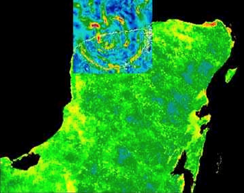
Gravity anomaly map of Chicxulub crater area superimposed on the Yucatan Peninsula showing areas of mass concentrations (yellow and red areas are “gravity highs’; green and blue areas are “gravity lows”). Credit: NASAFor more than a century, scientists studied rocks above and below the boundary between the Mesozoic Cretaceous Period and the overlying Cenozoic Paleogene Period. Where the boundary is well preserved, a thin clay layer exists right at the top of it.
In the1970’s, geologist Walter Alvarez showed his father, Nobel prize–winning physicist Luis Alvarez, this 1-cm-thick clay layer near the town of Gubbio in central Italy.
Luis Alvarez asked his colleagues at Lawrence Berkeley National Laboratory to use nuclear-activation analysis to figure out the elements present in the clay. They found it to be highly enriched in iridium—one of the rarest elements in Earth’s crust but plentiful in meteorites!
Iridium (Ir) is a transition metal of the platinum group with element number 77. It is the second densest element (after osmium) and the most corrosion-resistant metal known, even up to temperatures of 2000oC.
Other researchers retested the Italian samples as well as samples from similar clay layers in other regions of the world (New Mexico, Colorado, Tunisia, Denmark). Their tests confirmed the original result and documented high iridium concentrations in the boundary clay layer in widespread continental and oceanic deposits.
The research team published an academic paper with their results in 1980, but the scientific community was still dubious about an impact event because there wasn’t a known crater.
In the 1950’s, the Mexican oil company Pemex had found a large semicircular gravity anomaly on the northwestern corner of the Yucatán Peninsula that they thought might be a volcano.
They drilled boreholes into the structure, but their bias led them to the conclusion that it must be a volcanic center. They interpreted the rocks drilled to be intrusive and extrusive (coarser and finer grained) andesite (halfway between granite and basalt in composition) and associated pyroclastic tuff.
Pemex scientist Antonio Carmargo presented these drilling results at an industry professional meeting in 1981, but no one who knew about the iridium-bearing boundary layer was in attendance—there was no Internet to immediately connect scientists and ideas like there is today!
The academic scientists kept looking at the Cretaceous–Paleogene boundary layer around the world.
The thin clay layer at several locations also contained soot from wildfires and the following rare minerals that form only under very high pressures:
Shocked quartz crystals, which develop when planes in the crystal structure are displaced under extreme pressure like that found in nuclear explosions or meteorite impacts. Because volcanic temperatures would repair the shock plates by bonding and toughening them, these crystals rule out any association with volcanism.
Glassy spherules, which took shape as vaporized rock expanded into the atmosphere, condensed and solidified as glasslike droplets, and fell back to Earth to be preserved in the boundary clay.
Microscopic diamonds, which form under very high pressure by changing the crystal structure of organic carbon in sediments.
Scientists then discovered some important clues on the island of Haiti.
An unusually thick deposit was discovered along the Cretaceous–Paleogene boundary: 18 inches (46 cm) of impact spherules topped by an iridium-rich layer including shocked quartz grains.
A bed of reworked impact ejecta more than 4 ft thick was found nearby in deepwater sediments 6,000 ft (2,000 m) below sea level at the time of impact—probably the product of landslides caused by earthquake activity that continued after the impact.
That these deposits were many times thicker than the boundary layer found in other parts of the world meant that the crater had to be somewhere close to Haiti: in the Caribbean or Gulf of Mexico.
Later, much thicker deposits of reworked impact ejecta were found in the Gulf of Mexico.
Researchers then accessed and re-examined rocks and geophysical logs from deep in the old 1950’s Pemex boreholes, which were onshore within the central part of the circular structure. They also used newer geophysical methods of the day to better understand the anomaly originally noticed in the late 1970’s.
They determined that the drilling samples were not from magmatic intrusions and extrusions but, rather, included shocked quartz, diagnostic of high pressure.
They found sediments at the top; then breccia; then an impressive 1,246 ft (380 m) of impact melt; and, finally, anhydrite that had been deposited in the shallow seas at the site before the impact.
Academic and Pemex geoscientists also used newer geophysical data that showed a huge ringlike structure with both a gravity signature and a magnetic signature. Half of it is located onshore, half offshore in the Gulf of Mexico.
Researchers, in particular Alan Hildebrand, and company scientists worked together and published their results in 1991 and 1992. (Sadly, Dr. Luis Alvarez died before the confirmation of the impact theory.
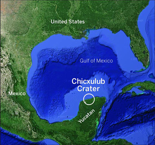
Regional map showing location of Chicxulub crater. Credit: UT Austin Jackson School of GeosciencesThe Chicxulub crater is named after the town close to the Gulf coast that it encircles. Chicxulub (CHICK-zoo-loob) roughly translates from Mayan as “tail of the devil.”
Unlike the tiny Barringer Meteor Crater impact 50,000 years ago, the Chicxulub crater is barely discernable at the surface, with more than 3,000 ft (1,000 m) of sediments burying it. It can, however, be seen from space using satellite imagery. NASA radar data shows a slightly lower land surface inside the crater.
Groundwater flowing northward toward the Gulf of Mexico over tens of thousands of years has been diverted along faults within the inner ring of the crater that formed during impact.
Fluids following these fault pathways slowly dissolved the limestone, creating a series of linked caverns surrounding the inner crater that are observable at the surface as more than a thousand “cenotes,” or water- filled sinkholes. In the past, these cenotes were used for Mayan human sacrifice, but today they are, thankfully, only used for recreation!
In the mid-1990’s, scientists used seismic data to better understand the structure and composition of the buried crater.
Features of craters depend on their scale. Smaller craters are bowls, large craters have a peak in the middle, even larger ones develop a single ring of peaks, and the largest have multiple rings of faults surrounding a peak ring.
Geophysicists determined that the Chicxulub crater has a single peak ring and multiple rings surrounding it, with a crater diameter of about 125 miles (200 km).
At the time of impact, the Yucatán peninsula was a shallow sea underlain by limestones and rocks, including sulfates, made from evaporated seawater. This shallow water may have been a big factor in the devastation caused by the impact.
Researchers initially theorized that the rocks of the peak ring must have come from the mid-crust. However, the speed of the seismic waves through the rocks indicated that the materials in the peak ring were much less dense than would be expected from mid-crustal rocks.
In 2001–2002, the International Continental Scientific Drilling Program (ICDP) drilled the Yaxcopoil-1 well south of Yucatán’s capitol city of Mérida.
With a drill site based on gravity data, the well penetrated a slump block near the inner ring of the crater and found 100 m of impactites lying above tilted blocks of older Cretaceous sediments that slumped into the crater during impact.
In 2005, researchers acquired a new seismic survey that demonstrated the size of the crater and architecture of the peak ring, enabling them to map the area in the crater most damaged by the impact processes, including the low-density rocks of the peak ring.
Researchers calculated the massive power of the impactor to be equivalent to ten billion times the energy released in the Hiroshima nuclear explosion.
In 2010, 41 international scientists joined forces to publish a paper tying the asteroid impact to the mass extinction using evidence from boundary sections all over the world.
In 2016, an International Ocean Discovery Program (IODP) expedition drilled into the peak ring of the crater about 15 miles offshore of Progreso, Mexico. We’ll talk about what they found out about the impact of the meteorite on Earth’s crust, what happened on the surface of Earth, and how life responded after the disaster in future EarthDate episodes.