Previously, we talked about California’s 1861 super flood that turned its Central Valley into an inland sea.
That flood was caused by an ARkStorm. The A R in Ark stands for Atmospheric River.
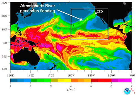
Atmospheric rivers are layers of water vapor that form in the tropics and circle the globe.
They’re very large—up to 2 miles high, 500 miles wide and 5,000 miles long. Each can carry 15 times the flow of the Mississippi River.
Atmospheric rivers are always forming, and always flowing—until they hit something like a mountain range, that forces them up into the colder atmosphere, where they condense into rain.
In this way, they provide 90 percent of the rain in the mid-latitudes, and up to 50 percent of California’s.
But they can also bring extreme floods.
Sedimentary records show this has happened in California 10 times in the last 2,000 years, suggesting that California is due for another one.
Since the 1861 flood, the state’s population has increased more than 100-fold. Millions of people now live in areas vulnerable to droughts, fires and floods.
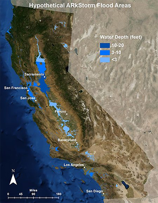
Scientists predict an ARkStorm could flood a quarter of California homes, cause one and a half million people to evacuate, and leave almost a trillion dollars in damages.
A California super flood is as likely as a super quake but could be three times more devastating.
Background
Synopsis: In a previous EarthDate episode, we recounted the story of a disastrous flood that occurred more than 150 years ago in California, brought on by an onslaught of storms that raged for more than six weeks, creating an inland sea in California’s Central Valley. The flooding was caused by an extreme atmospheric river event. Atmospheric rivers generally hit California every year, but extreme ones, such as the 1861-1862 event, only occur every 150-200 years, according to geological records. They are just as likely as a future major quake and could cost California three times as much.
- Geological records show that California’s historic six-week storm of 1861-1862 was caused by an extreme series of atmospheric rivers that hit the West Coast from Southern California to Oregon.
- Atmospheric rivers are concentrated layers of water vapor that originate from tropical evaporation and are transported out of the tropics on strong, fast winds. More than 90% of the moisture found in the mid-latitudes arrives within them.
- These vast streams of cloud droplets can be thought of as the largest rivers on the planet, but they flow in the atmosphere instead of across the land.
- Three to four are developing or flowing in both the Northern and Southern hemispheres every day.
- On average, they transport 7.5-15 times the amount of water flow from the mouth of the Mississippi River.
- They tend to be narrow, just 250-375 mi (400-600 km) wide.
- They range from an average of 1,200 mi (1,930 km) long to a more than 5,000-mi (8,000-km)-long storm that hit California in 2017.
- They extend from the surface up to 10,000 ft (3,000 m) in height.
- A famous atmospheric river type is the so-called Pineapple Express that is propelled by the jet stream, carrying water vapor from near Hawaii to the California coast.
- Atmospheric rivers continue to circulate in the atmosphere until something perturbs their path, like the coastal mountains along western North America that force them upward, into colder air.
- This “orographic lifting” causes water vapor in the sodden clouds to condense into rain or snow; California gets 30-50% of its annual precipitation this way.
- However, atmospheric rivers may produce extreme amounts of rain, especially if they stall over an area, resulting in floods, mudslides and dam breaches.
- In extreme scenarios, multiple atmospheric river events may strike the same area for weeks, as happened in 1861-1862.
- As global temperatures warm, evaporation will increase, enabling atmospheric rivers to carry more water out of the tropics.
- Sedimentological records show that extreme storms and flood events occur every 150-200 years.
- Silt deposits record megafloods that occurred in AD 212, 440, 603, 1029, 1300, 1418, 1605, 1750, 1810 and 1861-1862—ranging from 51- to 426-year intervals with a mean return period of 150-200 years.
- Storms in 440, 1418, 1605 and 1750 were more intense than the 1861-1862 event; the storm in 1605 deposited 2 in (5 cm) of silt in the Santa Barbara Basin, indicating that it was 50% more powerful than any of the others.
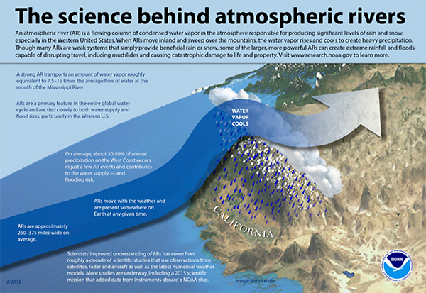
The science behind atmospheric rivers. Credit: NOAA [https://www.esrl.noaa.gov/psd/arportal/about/pdf/noaa-atmospheric-rivers-infographic.pdf] - With historical proof in hand, in 2010, the U.S. Geological Survey developed a storm projection called the ARkStorm Scenario. The name is an acronym for Atmospheric River k (=1000-year) Storm.
- It uses the pattern of the successive historical storms of 1861-1862 and actual data from 1969 and 1986 storms to evaluate the hazard of extreme atmospheric river storm disasters that could occur in California’s future.
- Model results suggest that there is a 50:50 chance of an “ARkStorm” hitting California by 2060, with disastrous results:
- Thousands of square miles and one in four buildings in the state would be inundated as floodwaters exceed the capacity of drainage to the sea, similar to what happened to Houston in the wake of Hurricane Harvey.
- Property repair costs would exceed $400 billion and business interruption costs are estimated at $325 billion, with a total cost of $725 billion. That is three times the estimated cost of a severe Southern California earthquake that has about the same probability of occurrence.
- Today, California’s population is more than 40 million people, 100 times larger than in the 1860s. More than 1.5 million would need to evacuate, a very dangerous situation that could result in substantial loss of life.
- Megastorms like the ARkStorm scenarios are California’s other “Big One.” The best hope is meteorological prediction of future similar events and an understanding of preparedness and potential vulnerabilities through emergency services drills.