Historical positions of Earth’s North Magnetic Pole, where the direction of the magnetic field is vertical. The pole is currently moving toward Siberia at 34 miles per year. Red circles mark North Magnetic Pole positions as determined by direct observation; blue circles mark positions modeled using the GUFM model (1590–1890) and the IGRF-12 model (1900–2020). Credit: Cavit (CC BY 4.0 [https://creativecommons.org/licenses/by/4.0])
Earlier on EarthDate, we talked about the three North Poles.
Of these, geographic north, the tip of Earth’s axis, defines latitude and longitude on our maps, while magnetic north is what compass needles point toward.
Unfortunately, geographic north and magnetic north are not in the same place. So the north of our maps and the north of our compasses don’t match.
The difference between them is called declination.
To complicate matters, declination varies depending on your location. Compass navigations have to be offset by the declination of that particular spot to make them accurate to the map.
Now for the real curveball: magnetic north is always moving!
It’s based on Earth’s magnetic field, which is created by turbulent currents in Earth’s molten metal outer core as they swirl around its solid iron inner core.
Shifting currents mean the magnetic field is always moving. Which means magnetic north is always changing. And declinations around the world are always adjusting!
We can see this effect all around us. Streets and walls built to compass north a few centuries ago may now be off by several degrees.
Runways, which are named by their compass orientation to help pilots navigate them, periodically have to be renamed when the declination of that spot changes.
To keep planes and ships safe, scientists track the movements of magnetic north and the constantly changing declinations and keep them updated every 5 years.
Background
Synopsis: Earth‘s North Magnetic Pole is moving nearly 500 ft per day compared to Earth’s Geographic North Pole!
In a previous EarthDate episode, we learned about Earth’s three North Poles.
Geographic, or “true,” north is where Earth’s rotational axis intersects its surface, defining latitude and longitude for maps.
Magnetic north is the location where compass needles point vertically down toward Earth’s magnetic field.
Geomagnetic north is the northernmost end of the theoretical dipole, or bar magnet, that approximately models Earth’s protective magnetosphere.
Earth’s North Magnetic Pole is constantly on the move.
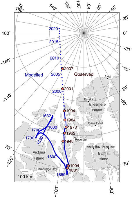
More than 400 years ago, in the mid-1600s, English mathematician Henry Gellibrand figured out that magnetic north had moved northward over the preceding 50 years.
Stone walls from colonial New England built along property lines surveyed by compass in the 1760s are perfectly straight, but if you use a compass to take their bearing, you will see the impact of 250 years of polar wandering: the walls are oriented nearly 7 degrees west of today’s magnetic north.
In 1860, after wandering southward for more than 200 years, magnetic north took an abrupt turn to the north and continued moving along a straight northward path, averaging about 9 miles per year (15 km/yr) throughout most of the twentieth century.
In 1990, it sped up dramatically, traveling 620 mi (1,000 km) in just 28 years.
It passed the International Date Line in 2017 on its way from Canada to Siberia and is currently zipping past the Geographic North Pole at a pace of about 34 miles per year (55 km/yr)—that is 500 ft (150 m) per day!
Earth’s magnetic field is driven by unpredictable eddies and swirls of the spinning liquid outer core that cause magnetic north to shift through time.
The turbulent molten iron and nickel surrounding the solid-iron inner core generates the magnetic field.
Scientists postulate that a high-speed jet of liquid iron deep under Canada may be weakening the magnetic field in that area, enabling a stronger magnetic field in Siberia to pull the pole eastward.
Eventually the magnetic field will weaken and flip, but scientists believe this will take thousands of years. Earth’s last magnetic reversal occurred about 780,000 years ago.
Earth’s North Magnetic Pole is always on the move. Credit: NASA Goddard Space CenterWe use magnetic north to calibrate and back up complex global navigation systems.
Since the 1980s, satellite-based global positioning systems (GPS) have reduced our reliance on compasses and magnetic north. But compasses still serve as important emergency-backup navigational systems on both ships and planes.
The National Oceanic and Atmospheric Administration (NOAA) and the British Geological Survey update the World Magnetic Model (WMM) every 5 years using data from satellites and a global network of more than 120 magnetic observatories. The goal is to be accurate within 1 degree of declination on a global basis.
The WMM is the standard navigation tool for NASA, NATO, the U.S. Department of Defense, and the Federal Aviation Administration (FAA), among others.
In 2015, the movement of magnetic north slowed briefly, influencing the 5-year WMM prediction. Not long after the 2015 update, however, the movement resumed its faster pace, so scientists issued an emergency update to the WMM in late 2018 to avoid potential problems with air traffic control and military and ocean navigation. The next update will occur as planned in 2020.
Predicting the acceleration and deceleration of this pole is essential to the critical systems of modern life.
Changes to magnetic north have the most impact north of 55 degrees.
As sea ice declines in the Arctic Ocean, compass navigation that serves as a back-up to modern GPS systems for both ships and aircraft may be particularly challenging so close to all of the polar wandering action.
Names of runways at airports around the world are based on degrees of magnetic compass direction.
A pilot landing or taking off due north uses runway 36, abbreviated from 360 degrees, which is north on a compass. A runway used to fly east is runway 9 (90 degrees), south is runway 18 (180 degrees), and west is runway 27 (270 degrees).
At larger airports where runways are wide enough to have two lanes, right and left lanes of the same runway may be designated. A north–south runway would be called 18L-36R.
In 2009, runway 1L-19R at the Fairbanks International Airport in Alaska was renamed 2L-20R as its heading increased above 15 degrees, requiring rounding up to 2L (20 degrees). It will probably have to be renamed again around 2033.
Since it opened in 1995, the declination of the Denver International Airport has changed 1 degree every 10 years, meaning that in another 30 years, some DIA runways will need to be renamed.
Magnetic south moves slower than magnetic north, at about 8 miles per year (13 km/yr) toward the northwest.