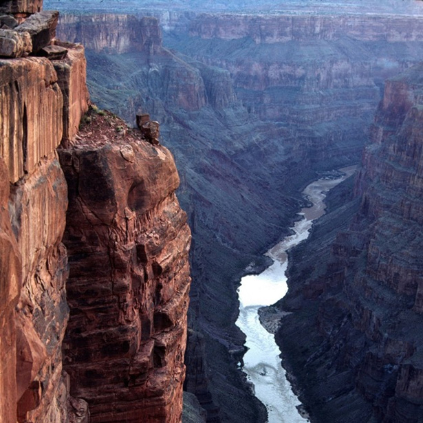
View up the Colorado River from Toroweap Overlook at the western end of the Grand Canyon. Credit: National Park Service
The Grand Canyon is so grand it can be seen from space. At more than a mile deep and nearly 300 miles long, it could hold all the world’s river water and still be only half full.
And its colossal size is an evolving mystery.
Early geologists could not believe such a comparatively small river could carve something so immense. So they looked more closely…
And discovered that a myriad of geological processes have combined to form the canyon through time.
One of the more dramatic is giant floods, vastly larger than anything we see today.
Floods from melting ice sheets. From enormous lakes overflowing their boundaries. From lava dams forming within the canyon, which held back water until they failed spectacularly.
Floodwaters can carry hundreds of times more rock material than a normally flowing river.
These superfloods likely dragged house-sized boulders through the canyon, battering the softer lower rock layers until they collapsed, bringing all the rock above them crashing down, to be carried away in the next superflood.
Geologists suspect these processes happened repeatedly in several smaller canyons, which finally linked together to become the Grand Canyon we know today.
In 1919, the U.S. Congress and President Woodrow Wilson set aside the canyon as a National Park for, as Theodore Roosevelt had said years earlier, “your children, your children’s children, and all who come after you.”
If you haven’t seen it with your own eyes, you owe it to yourself to go and be awed by the Grand Canyon.
Background
Synopsis: The steep walls of the Grand Canyon, a remarkable physiographic feature that can be seen from space, were carved by the Colorado River in northern Arizona through rocks on the Colorado Plateau. But exactly how and when more than 1,000 cubic miles of rock were flushed out of the canyon has turned out to be one of the biggest mysteries in geology.
The Colorado River starts on its 1,450-mile (2,350-km) journey in Rocky Mountain National Park in Colorado and in the Wind River Mountains in Wyoming. It then heads southwest across the Colorado Plateau and the Basin and Range Province, dropping nearly 13,000 ft (4 km) to its mouth at the Gulf of California.
Located between Lake Powell, in Utah, and Lake Mead, on the border of Arizona and Nevada, the Grand Canyon is grand indeed!
The Grand Canyon is about 278 miles (446 km) long and visible from space. If it were a highway, it would take you about 4 hours to drive its length at 70 mph.
It is as much as 1.15 miles (1.86 km) deep and more than 18 miles (29 km) wide in some places.
For every mile of length, the Colorado River drops about 8 ft (2.5 m), descending about 2,000 ft (600 m) from the beginning to the end of the Grand Canyon.
The volume of the eroded area in the canyon is staggering: about 1,000 cubic miles of rock have been removed. This space could hold all of Earth’s river water and still only be half full.
The Grand Canyon is located on the Colorado Plateau, a physiographic province (one of 26 in the United States) distinguished by its thickness of strata and crustal stability over geologic time.
While adjacent rocks were folded and faulted in response to tectonic forces, the Plateau remained intact through a billion of years of Earth history.
During recent tectonic events, the Plateau simply rose upward, with a slight clockwise rotation.
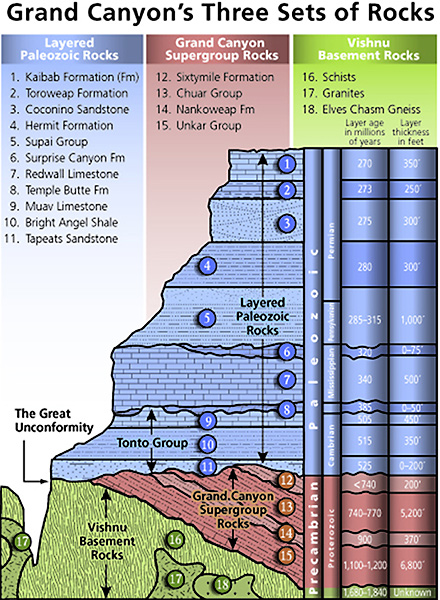
The rocks dissected in the canyon represent nearly 2 billion years of Earth's history.
Vishnu Basement Rocks are igneous and metamorphic rocks containing garnets that indicate they were once buried under a mountain range by at least 10 to 13 miles of additional crust (later eroded away). These ancient mountains were perhaps as tall as many of today’s highest volcanic mountain ranges (e.g., mountains in Indonesia and the Andes in South America). Later erosion flattened that mountainous landscape, creating nearly a half-billion-year gap in the rock record.
Sediments and volcanics of the Grand Canyon Supergroup were deposited from 1.2 billion to about 740 million years ago. These rocks were faulted and then eroded, with just a few angled remnants remaining.
Starting about 525 million years ago, flat-lying Paleozoic rocks record repeated marine and near-marine inundation and burial of the Plateau’s rocks for about a 450- million-year time period.
At the rim of the canyon, at over 9,000-ft elevation today on the North Rim, the Permian Kaibab Limestone contains marine fauna such as mollusks that lived and died in a shallow sea 270 million years ago.
Even-younger marine rocks once covered the Plateau, indicating that such rocks have likely risen at least 15,000 ft since about 70 million years ago. Uplift is a primary agent in creating the Grand Canyon.
Younger rocks present on the Colorado Plateau have been completely eroded in the area of the Grand Canyon, with the exception of recent lava flows.
Grand Canyon Stratigraphy Credit: National Park Service [Public domain], via Wikimedia CommonsWhen did the canyon form?
With its extremely rugged topography, the earliest scientists believed the canyon to be a young feature, since erosion tends to smooth Earth’s surface as time goes by.
For nearly 150 years, scientists argued about the age of the canyon, with hypotheses ranging from 70 million to 17 million to 6 million years.
Recent collaboration has offered a possible solution: the Grand Canyon formed about 5.5 million years ago after a series of smaller canyons, one as old as 70 million years, linked up.
What was the sequence of canyon-forming events?
Around 80 million years ago, the Western Interior Seaway ran from the Gulf of Mexico through Canada to the Arctic Ocean, covering the entire region—the river and canyon didn’t even exist!
By about 70 million years ago, Late Cretaceous subduction of oceanic plates below western North America uplifted and created an Andean-type mountain range to the southwest of today’s Grand Canyon, ultimately closing the seaway.
Deposits in rivers that drained these mountains (and other scientific evidence) clearly show that the rivers flowed toward the northeast—the opposite direction of the Colorado River flow today!
Researchers have used a laboratory technique to suggest that some western sections of the canyon were excavated to near their current depth by about 70 million years ago. This technology measures the cooling history of rocks; as upper layers are removed by erosion, the canyon’s rocks became closer to the surface and thus cooled below a threshold that is trapped in certain minerals and can be measured and dated.
By the Miocene Epoch, around 17 million years ago, a change in plate tectonics motion created extensional forces to the south and west of the Colorado Plateau that broke up the Andean-type mountains and reorganized regional river systems when the Basin and Range Province developed.
The San Andreas Fault developed around this time, as did some segments of the eastern canyon.
About 6 million years ago, the San Andreas transform boundary extended southward, opening the Gulf of California and lowering base level in the region. Scientists believe that at this time, the canyon segments began to integrate into the single river system we see today. Lake sediments downstream of the canyon tell a story of progressive lake spillover as the river made its way to the Gulf of California.
At the upper end of Lake Mead but just below the western end of the Grand Canyon, the 4.4-million-year-old Sandy Point Basalt covers debris undoubtedly from the Colorado River, revealing that a through-going river was in place by at least 4.4 million years ago.
Sediments from a sequence of lakes downstream from the Grand Canyon in the Las Vegas, Cottonwood, Mojave, and Chemehuevi closed basins demonstrate spillover into each other progressively southward from 5.6 and 4.1 million years ago, until they reached the Gulf of California.
Ice Age floods occurred repeatedly in the past 2.5 million years as Pleistocene glacial meltwater fed the headwaters of the Colorado, helping to deepen the current canyon.
Volcanism within the canyon near Toroweap Point occurred from 825,000 to just 1,000 years ago, repeatedly creating lava dams across the canyon that initially dammed water and then failed catastrophically.
Water, by itself, is not the primary agent in carving canyons. But it is a primary facilitator of the process. How did water help cut the Grand Canyon more than a mile deep and 18 miles wide?
Huge floods transport rocks and debris that batter canyon walls and floor to deepen it.
Each time floodwater doubles its volume (discharge), it can transport particles 4 times as large (competence) and carry a load 64 times as heavy (capacity).
There is no recorded history of flooding in the Grand Canyon that could transport the house-sized boulders that have been moved through it, but we know catastrophic floods occurred there in the past.
During abatement of a flood, the canyon refills with boulders and debris that protect its floor until the next flood. Today, the bed of the Colorado River is covered with up to 75–100 ft of boulders, gravel, and sand that protect its floor from erosion by the sediment-rich river. The Lake Powell reservoir protects the bed even more.
Rivers erode downward and headward (upstream) until they reach an equilibrium base level. The sea is the ultimate base level, but lakes act as intermediate base levels, as well.
If an area is above base level or undergoing active uplift, streams and rivers cut downward, eroding through topography.
Conversely, if an area is below base level, or subsiding, available sediments are deposited in deltas.
One of the chief processes considered important to the formation of the Grand Canyon is headward erosion and resulting “stream piracy.”
High-gradient streams always work to lower or cut down their steep gradient by lengthening their channel in the upstream direction, in a process known as headward erosion.
Sometimes a stream or river with a high gradient that is lengthening its channel upstream will intersect and “capture” another stream system. This stream piracy adds a drainage area to the primary stream and provides a new outlet for the stream that was captured.
Another important process in canyon formation may be “lake spillover.”
When tectonic processes change landscapes, drainage may become trapped by highlands with no outlet, forming closed basins.
As rivers and streams enter these closed basins, they can fill to create lakes that sometimes overflow on their lowest rim, causing lake spillover.
As lake spillover proceeds, the point of overspill becomes a knickpoint—a location of a sharp change in channel slope—that erodes as a narrow outlet progressing upstream with the receding lakeshore as the lake drains.
The development of karst in limestones in the Grand Canyon is also a potential contributor to erosion.
Karst features develop when limestone dissolves as groundwater moves through it, often resulting in springs and underground caves and caverns.
Some research suggests that collapse of an ancient cave system may have influenced the course of the Grand Canyon.
The width of the canyon has been caused by erosion in side-canyon streams, which have carved deep canyons themselves before entering the Colorado River.
Eroded material in side-canyon streams is transported to the river in floods.
Additionally, as softer layers of rock, like shale, are eroded and recede, they undermine the overlying harder layers that then collapse into the canyon, helping the process of canyon widening.
The Grand Canyon became an official national monument in 1908, and the Grand Canyon National Park was established in northern Arizona in 1919.
The canyon was once so impassable that American explorers Lewis and Clark referred to it as the “Great Unknown”—the area was left as a blank space on their 1804–1806 Discovery Expedition maps.
In the early 1800s, the Grand Canyon was known as the “Big Canyon” in English or the “Grand Cañon” in Spanish. The canyon was part of Mexico from 1821 to 1848, when it became part of the United States.
Explorer John Wesley Powell aptly promoted it as the “Grand Canyon” during his remarkable 1869 and 1871 expeditions.
It took the combined efforts of three U.S. presidents—Benjamin Harrison, Teddy Roosevelt, and Woodrow Wilson—from 1893 to 1919 to finally have the Grand Canyon National Park declared the 17th U.S. National Park on February 26, 1919.
In 1908, Roosevelt said of the Grand Canyon, “Let this great wonder of nature remain as it now is. You cannot improve on it. But what you can do is keep it for your children, your children’s children, and all who come after you.”
More than 6.38 million people visited the Grand Canyon National Park in 2018, 40 percent from foreign countries. (Only Great Smoky Mountains National Park in the Appalachians had more park visitors.) It just recently celebrated its 100th anniversary.