From an earlier EarthDate, you may remember John Wesley Powell, who mapped the Grand Canyon and became one of America’s leading geologists.
After his trip, he studied the American West—then called the Great American Desert.
Powell realized its dryness—with rainfall below 20 inches a year—made it fundamentally different than the rest of the country.
He predicted that farming and settlement methods used in the East and Midwest would fail, and proposed to Congress a much different approach: Don’t divide the West into states with straight-line borders as elsewhere; instead, follow the water.
Organize it into commonwealths by watershed, so that all water in one area was under one jurisdiction.
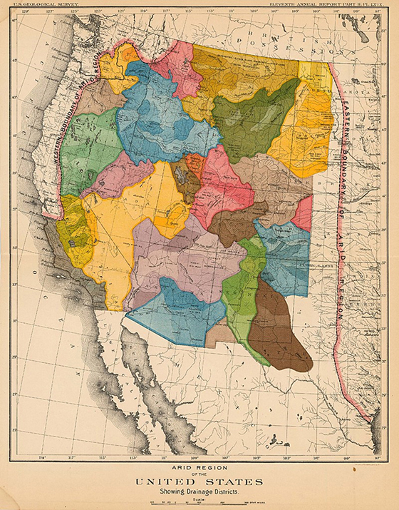
His proposed map looked very different, with organically shaped borders following ridgelines and drainage plains, each unit containing its own rivers and streams as water sources.
Within those watersheds, he proposed a much larger farm size, and reserved drier areas for grazing or no development at all.
Powell’s goal was to avoid water battles in the West and better manage resources. But others had different ideas, and Congress was not persuaded.
Instead, the government embarked on 100 years of building canals, reservoirs, and irrigation systems.
These were successful in populating the West much more densely than Powell proposed.
But that population now struggles with water supply, drought, and falling water tables, just as he predicted.
Background
Synopsis: John Wesley Powell saw that water management for irrigation would be a pivotal issue—one that state governments would be wrestling with endlessly—throughout the western United States. So he proposed a novel idea: commonwealth boundaries based on watersheds. But Congress couldn’t be persuaded and chose straight lines for borders instead. It was a watershed moment…
- Hydrogeologists think of surface-water resources in terms of watersheds.
- A watershed is a catchment basin surrounded by drainage divides that cause any precipitation that falls within the area to be channeled to a common outlet.
- Some watersheds may be tiny, but they join up to form larger networks that progressively drain into larger common outlets, until they reach the sea.
- The Mississippi River watershed is the largest in the United States, collecting drainage from 31 states and 2 provinces in Canada—an area of more than 1.15 million square miles.
- After his historic navigation of the Grand Canyon in 1869–71, John Wesley Powell was named director of the Geographical and Geological Survey of the Rocky Mountain Region. In this role, he traveled, studied, and mapped the newly acquired territories of the western United States, especially the Colorado Plateau.
- Near the 100th meridian, Powell noted that rainfall dropped off dramatically, with the 20-inch annual precipitation line marking the boundary between the arable East and the arid West.
- Early explorers called the American West the “Great American Desert.”
- In 1877, Congress passed the Desert Lands Act and the Timber and Stone Act, which offered western land for exploitation at as little as 25 cents per acre.
- In his 1878 “Report on the Lands of the Arid Regions of the United States” presented to Congress, Powell concluded that the West did not have enough water to support the population levels and agricultural intensity of the East. He made a visionary proposal that the western territories be divided into governmental units based on watersheds.
- Powell recognized that farming methods used in the Midwest would fail in the West.
- In the fertile Midwest, farms were cut up into 160-acre square tracts, but in the West, Powell recommended that ranches designated for grazing should be set up at 16 times that size—a minimum parcel size of 2,560 acres, each with access to a stream. That meant some acreage would never be developed.
- Powell advocated for local irrigation cooperatives centered around small dams and reservoirs, with watersheds nesting together as the fundamental unit of government.
- He suggested that federal assistance would be needed to analyze and manage resources, and to prevent export of water to areas far from its source.
- Colorado’s first territorial governor, William Gilpin, disagreed with Powell. Gilpin promoted the now-discredited “rain follows the plow” theory, which suggested that as settlement occurred, with more crops and trees planted and reservoirs built, more rain would fall in the region to support the settlers.
- Many families that headed west suffered mightily as the “rain follows the plow” utopian prediction proved to be a fallacy.
- Just a year after Powell’s report and recommendations were published, Congress passed a 1879 law that merged regional geological surveys into a single United States Geological Survey (USGS).
- Unfortunately, the same law dismissed the recommendations of the Powell report. Strong railroad lobbies supporting large-scale agricultural settlement saw too much regulation in the proposal.
- Powell was recognized as a leading American scientist, and in 1881 he became the second director of the USGS, shaping its scientific approaches to the present.
- He championed the development of consistent national mapping standards, including the use of single geodetic and topographic systems, standard map scales, and the colors geologists use to this day to indicate the ages of rock units.
- Powell launched systematic water and climate studies to help with land-use planning for the American West.
- In 1883, Powell warned that Congress was “piling up a heritage of conflict and litigation over water rights.”
- In 1888, Congress gave him the go-ahead to complete an irrigation survey of all public domain lands in the West. It would take 7 years, and land would not be released for agricultural development until after the survey was complete. Opponents in Congress challenged the survey continually and succeeded in cutting funding in 1890, ending the effort after just 2 years.
- Powell resigned in frustration from the USGS in 1894, with many accolades but little acceptance of his ideas about western land use.
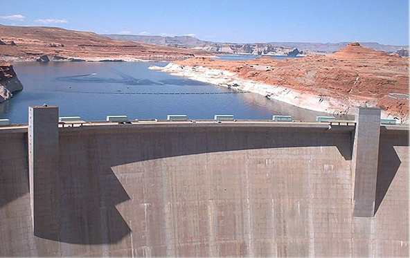
- In 1899, Congress launched 100 years of dam and canal construction projects subsidized by the federal government to create vast regions of irrigated farmland and hydroelectric power—exactly what Powell argued against.
- Ironically, one of these projects, Lake Powell, was named after him.
- Such massive water projects created the western water-rights struggles that shut out the small farmer in favor of mega-farms. The water wars continue today—just as Powell predicted.
- Powell served as director of the Smithsonian Institution’s Bureau of Ethnology until he died in 1902 at age 68.