In the mid-twentieth century, NASA scientists launched the first satellites to view Earth.
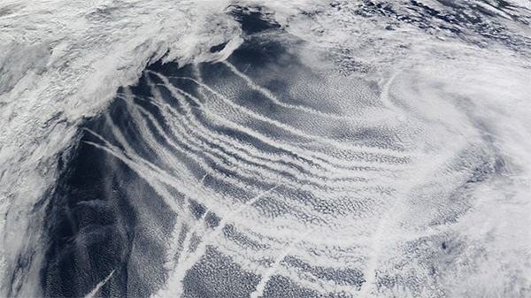
When they looked at the photos, they saw mysterious stripes of clouds crossing the oceans.
On closer inspection, they realized these cloud trails followed the shipping lanes.
In the mid-nineteenth century, after collisions between ships, nations designated lanes across the seas that ships would follow to avoid accidents.
As traffic grew over the twentieth century, more and more ships plied these maritime highways. But what caused the clouds?
Scientists realized that the exhaust plumes of hundreds or thousands of diesel-fired ships carried streams of aerosols and fine particulates into the low atmosphere, along the shipping lanes.
Water vapor condensed on these to form the trails: the ships were making their own clouds.
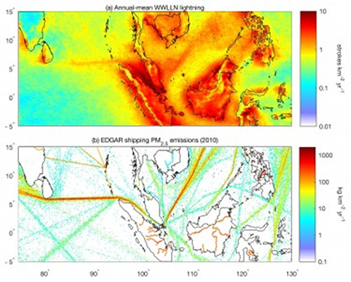
Newer satellites discovered something more. They picked up magnetic pulses from lightning patterns across the ocean, and the lightning also followed the shipping lanes.
Scientists now understand that the tiny water droplets in the ships’ cloud trails, finer than in regular clouds, are more conducive to lightning formation.
The ships actually make their own lightning storms, and the weather in their wake is more severe than over open ocean.
So if you’re having one of those days when it feels like a storm cloud is following you around—if you’re the captain of a cargo ship, it just may be.
Background
Credit: Thornton et al | Geophysical Research Letters | AGU
Synopsis: Researchers have found that ships cause their own severe weather in shipping lanes around the world. Ship exhaust creates weather conditions that cause both cloud formation and enhanced lightning from cumulonimbus cloud formation.
- Shipping lanes, or sea lanes, are designated routes regularly used by large vessels in oceans or large lakes.
- For millennia, mariners learned to steer their ships to take advantage of both currents and prevailing winds, especially important in the era of sailing ships.
- As the seas became more crowded, they became more dangerous. In late 1854, the U.S. mail steamer SS Arctic collided with the French steamer SS Vesta, resulting in the loss of 300 lives.
- Sea-lane safety proposals were debated for nearly 50 years, but finally, in 1914, specific routes were designated across the Atlantic.
- From 1960 to 1967, the NASA Television InfraRed Observation Satellite (TIROS) mission launched ten meteorological satellites that carried infrared radiometers and both wide-angle and telephoto television cameras into space for the first views of Earth from space.
- In 1965, the TIROS VII satellite detected unusual linear lines of clouds over the ocean. When compared to shipping lanes, researchers hypothesized that the anomalous clouds were ship tracks, somehow created by ship exhaust.
- Today, ship-track clouds are common on satellite images of the ocean and can be detected even within regular clouds because they are usually brighter and more reflective, especially in near-infrared light.
- As cargo ships travel along shipping lanes, their smokestacks send concentrated streams of tiny aerosol particles into the atmosphere that serve as cloud nuclei.
- These sulfur dioxide nuclei are pollutants
- Water vapor condenses on the cloud-condensation nuclei to form cloud droplets, which are smaller than those in natural clouds.
- Large raindrops tend to form when there are fewer nuclei in the air to attract water-vapor condensation.
- Higher concentrations of nuclei, like those in ships tracks, create a larger number of smaller droplets but may not become heavy enough to fall as rain.
- Sometimes temperature inversions occur over oceans, trapping low-level clouds like ship tracks for days.
- These manmade clouds can cool Earth’s surface, suppressing water evaporation and hogging the available water vapor—thus inhibiting the formation of larger rain clouds.
- As cargo ships travel along shipping lanes, their smokestacks send concentrated streams of tiny aerosol particles into the atmosphere that serve as cloud nuclei.
- Recently, researchers from the University of Washington’s World Wide Lightning Location Network (WWLLN) made another startling discovery about ship tracks.
- Lightning creates low-frequency magnetic pulses that can be detected by satellites.
- While creating maps of average annual lightning density in Asia, scientists noticed straight tracks across the seas accompanied by twice the normal amount of lightning.
- These lines ran from the northern end of Sumatra to Sri Lanka, and from Singapore into the South China Sea, right along two of the region’s busiest shipping lanes.
- Although the lightning was twice the normal amount, the amount of precipitation was not different from other rainclouds in the region.
- Scientists hypothesize that the smaller, lighter ship-track cloud droplets are more easily lofted tens of kilometers into the atmosphere, where they can freeze and collide, becoming electrified and producing lightning-rich cumulonimbus clouds.
- This aerosol convective invigoration effect was first noticed over land near soot-producing fires, although in general the effect is easier to study over oceans than over land.
- Future studies of global lightning will be enhanced by the recent launch of the GOES-16 Geostationary Lightning Mapper (GLM), which is dedicated to state-of-the- art lightning detection.