Credit: Jens Bludau, via Wikimedia Commons
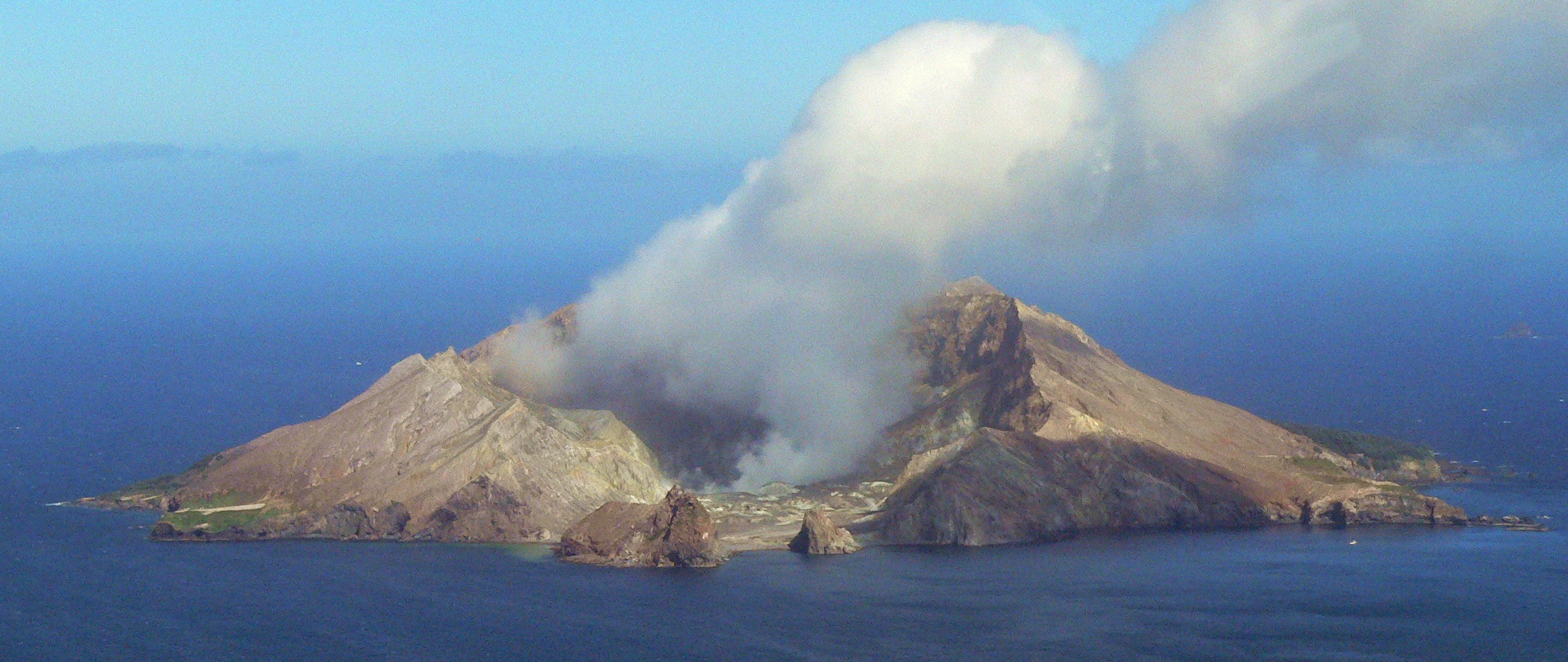
Whakaari/White Island is New Zealand’s largest active volcano. Its crater forms a huge natural amphitheater that opens to a bay.
In December 2019, a large group of tourists arrived for a day trip. They donned gas masks to watch fumaroles spew clouds of yellow steam.
Then, disaster struck. The volcano erupted suddenly, belching vapor and ash two miles into the sky. The cloud collapsed into the amphitheater, which funneled it directly at the tourists.
Half were killed and the other half suffered severe burns and lung damage from sulfuric acid fumes.
Scientists set out to analyze the eruption. Like most in the region, and many of the largest in the world, it was hydrothermal.
Water trapped in rock pores becomes superheated by shallow magma, increasing pressure. Then an external trigger, like a seismic tremor, destabilizes the system causing a huge instantaneous steam explosion.
Researchers used modern machine learning to analyze 40 years of eruption data at Whakaari. They found seismic patterns of magma movement in the subsurface, which superheated water and triggered the steam release.
Their new understanding could help predict future eruptions here. But the technique will have to be customized for other volcanoes and, for some, warning time may be very short.
If you’ve ever thought about visiting an active volcano, you should be aware that none are completely safe.
Background
Synopsis: New Zealand’s most active volcano on White Island attracted as many as 17,500 tourists per year. But during the afternoon of December 9, 2019, a sudden violent eruption occurred, spewing a huge deadly surge of hot ash and steam toward the 47 individuals who were touring the island. Twenty-two died, while the remaining 25 suffered horrific burns. While hazard warnings had been elevated in the weeks before the incident, that morning the volcano appeared normal. Volcanic eruptions are notoriously difficult to predict, but scientists have now developed a new tool that watches for signature seismic rumblings that precede eruptions by more than 12 hours on White Island. This new tool may be customizable for similar volcanoes.
- On December 9, 2019, several boats departed from the coast of the North Island’s Bay of Plenty under a bright blue sky for an exciting 30 mi (48 km) day trip to observe New Zealand’s most active volcano, Whakaari/White Island.
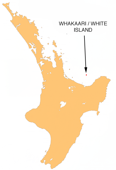
Location map of Whakaari/White Island in the Bay of Plenty northeast of New Zealand’s North Island.
Credit: Moriori at English Wikipedia, public domain, via Wikimedia Commons- This day trip was a highlight for many who arrived on a cruise ship that was docked at the bayside town of Whakatāne.
- The boats anchored in Crater Bay on the southeastern side of White Island where the collapsed crater rim creates a large amphitheater.
- For the island tour, they donned gas masks and hard hats for the half mile trek toward the acidic crater lake where they could observe fumaroles emitting roiling sulfurous steam.
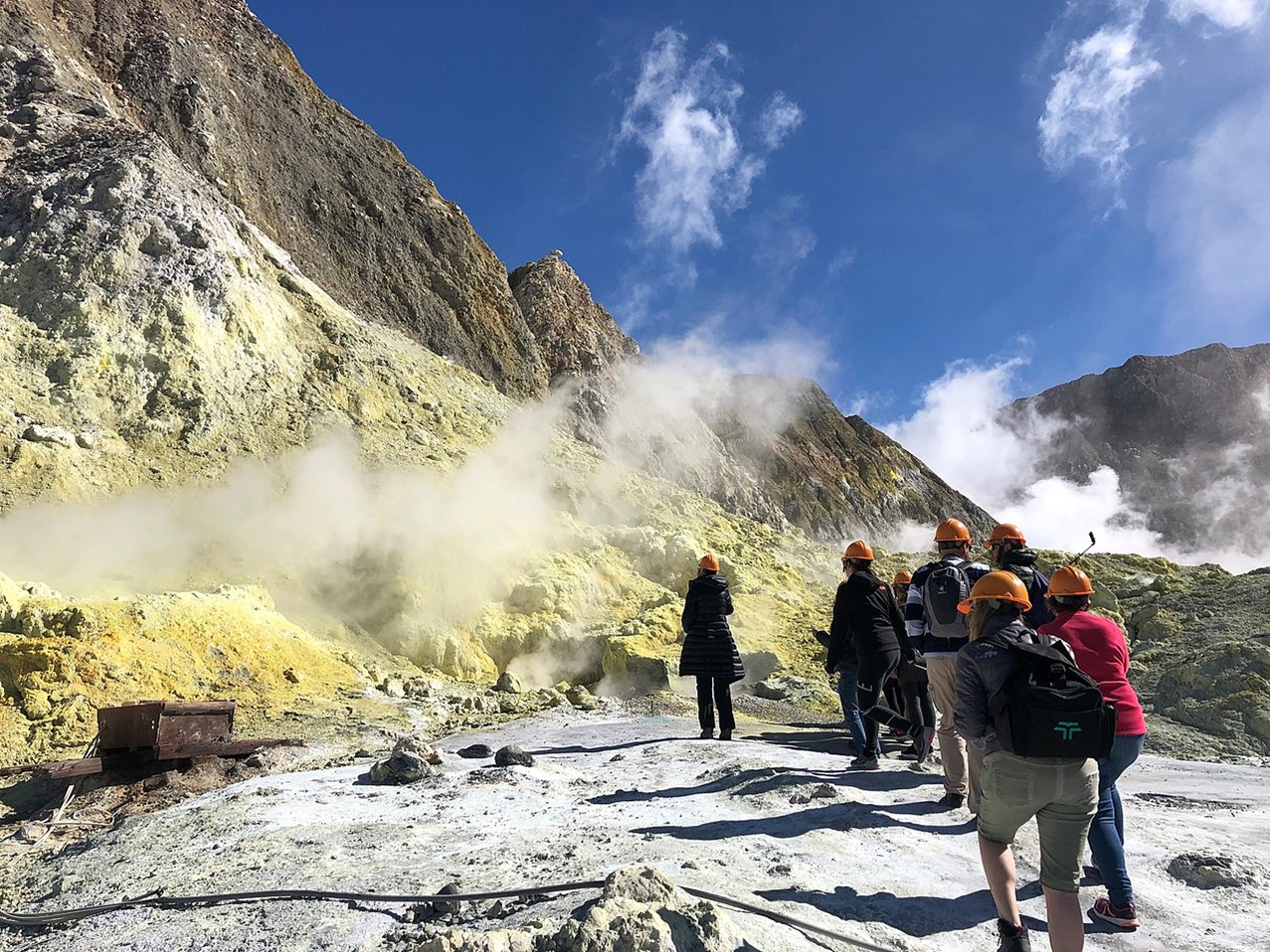
Tourists on Whakaari/White Island in April 2019.
Credit: Kimberley Collins, via Wikimedia Commons - At 2:11 p.m. local time, the volcano erupted while 47 people hiked between the crater lake and the shore. Dozens more were offshore on boats in the bay.
- Whakaari belched a huge gray-black sulfurous cloud of steam, toxic gas and ash more than 2.25 mi (3.65 km) into the atmosphere.
- The pyroclastic cloud collapsed back to earth where the amphitheater funneled it directly toward the boats and the tourists.
- Ultimately, 22 died and two of the bodies were never found. The remaining 25 suffered severe burns from the steam and sulfuric acid in the surge.
- The victims were from Australia, the United States, China, Malaysia, Germany, the United Kingdom and New Zealand.
- Rescue efforts were severely hampered by low visibility and toxic gas emissions, additional seismic and volcanic activity, and heavy rainfall after the event.
- A 1914 tragedy that killed more than ten sulfur miners was attributed to an debris avalanche along the crater rim, not volcanism.
- Whakaari/White Island is the exposed tip of New Zealand’s largest volcano, with more than 70% of the mountain below sea level.
- The exposed island is about 1.9 mi (3 km) long and 1.2 mi (2 km) wide with its highest point 1,053 ft (321 m) above sea level.
- Measuring from the seafloor, the volcano rises to a full height of 5,249 ft (1 mi or 1.6 km) with a diameter of more than 10 mi (16 km) and a total volume of 19 cubic miles (78 cubic km).
- The floor of the main crater/amphitheater is around 98 ft (30 m) above sea level.
- The official name of the island is Whakaari/White Island, which is a combination of its Māori name Te Puia o Whakaari, "The Dramatic Volcano," with the name it was given by Captain James Cook in 1769, White Island, because of its characteristic white steam plume that has been evident for centuries.
- The island is privately owned and was declared a private scenic reserve in 1953.
- White Island occurs at the southern end of the Havre Trough, part of the extensive back-arc basin system west of the subduction boundary where the Pacific Plate dives beneath the Australian Plate.
The Pacific Plate to the east subducts below the Australian Plate along the Kermadec Trough. The Havre Trough is part of the back-arc basin system that has developed over the subducting plate.
Credit: Alexrk, via Wikimedia Commons- The stratovolcano is made of overlapping andesite and dacite lava flows with layers of tuff and pyroclastic deposits that have built up over more than 150,000 years from two craters, one of which is now extinct.
- It is the northernmost active volcano of the Taupō Volcanic Zone that stretches from Lake Taupō in the center of the North Island offshore to White Island.
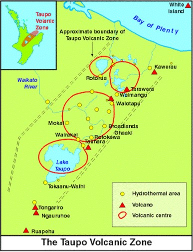
The Taupō Volcanic Zone is a 217 mile (350 kilometer) long zone of intense volcanism and hydrothermal activity on New Zealand’s North Island. The Whakaari/White Island volcano is at the upper right corner of the map.
Credit: GNS Archive - Like many of the volcanic centers in the Taupō Basin, Whakaari/White Island is the site of a highly reactive hydrothermal system characterized by boiling acidic lakes, steaming fumaroles, hot springs and mud pools.
- Evolved gases include water vapor, carbon dioxide, sulfur dioxide, and small amounts of chlorine and fluorine, resulting in highly acidic vapors that may injure lungs and damage equipment.
- The island is an excellent modern analog for the development of metal rich porphyry copper deposits, so it has been studied extensively in recent years.
- White Island has been a popular tourist attraction precisely because it has been the country’s most active volcano since 1976.
- Nearly thirty explosive eruptions have occurred on White Island since observations began in 1826 and was especially active from 1976 to 2001. It has erupted five times in the past 20 years (2000, 2012, 2013, 2016 and 2019).
- Most eruptions on the island have been phreatic or phreatomagmatic in style, meaning they involve water or water and magma.
- The 2019 eruption was a phreatic or hydrothermal explosion.
- In hydrothermal eruptions, water trapped in pores becomes progressively superheated by shallow magma creating a delicate balance between pressure, volume and temperature.
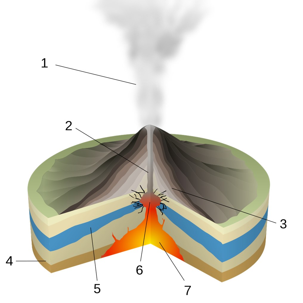
Diagram of the interaction of magma and water in a phreatic eruption. 1-Steam cloud, 2-Magma conduit, 3-Lava and ash layers, 4-Rock below volcanic deposits, 5-Groundwater, 6-Explosive eruption, 7-Magma Chamber.
Credit: Sémhur, via Wikimedia Commons - External processes including earthquakes, changes in lake water level, magma movement or gas input from below can set off a steam-driven eruption that is similar to blowing the lid off a pressure cooker.
- When water turns into steam, it expands to 1,700 times its original volume, catastrophically splintering rock and blowing fragments and ash upward in a steam surge that then collapses to run outward along the ground.
- These blasts are short lived; the December 2019 eruption lasted only 12 minutes.
- Many world-famous volcanoes have histories of phreatic explosions, including Krakatoa (1883), La Palma (2021), Kīlauea (1924), and Mount Ontake (2014) in Japan with a death toll of more than 60 hikers. Yellowstone’s geysers are examples of fairly predictable hydrothermal eruptions.
- In hydrothermal eruptions, water trapped in pores becomes progressively superheated by shallow magma creating a delicate balance between pressure, volume and temperature.
- Because of the subtleties of local changes within hydrothermal systems, forecasting these types of volcanic events is challenging, especially since instrumentation must be spaced closely enough to capture localized variations.
- New Zealand’s GeoNet team continuously monitors many of New Zealand’s volcanoes, including Whakaari.
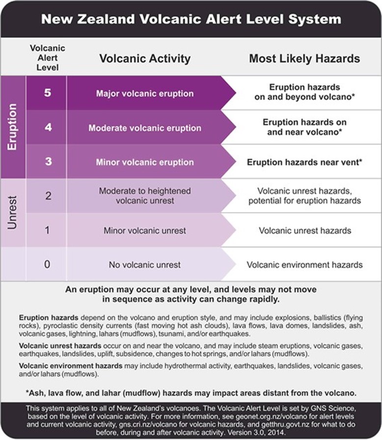
GeoNet’s Volcano Alert Level (VAL) system has been instituted on a scale of 0 to 5, with 0 to 2 being pre-eruption and 3 to 5 being post-eruption.
Credit: GeoNet - To get to the surface, phreatic fluids must break rock, creating seismic swarms and causing the surface to rise, so instruments warn us about volcanic unrest; but the timing of an imminent eruption is difficult to predict, especially with steam-driven systems.
- Webcams, acoustic sensors, magnetometers, UV spectrometers, satellite navigation systems and seismometers have been deployed around the crater to sense seismic tremors, explosions, SO2 emissions and ground deformation to aid forecasts.
- Typically, White Island is on alert levels 1 or 2, with 2 being the highest level of alert before an eruption occurs, indicating “moderate to heightened volcanic unrest” with the “potential for eruption hazards.” Levels 3 and higher are reserved for ongoing active eruptions.
- Government agencies use the information from GeoNet and other monitoring agencies to make decisions about hazard safety.
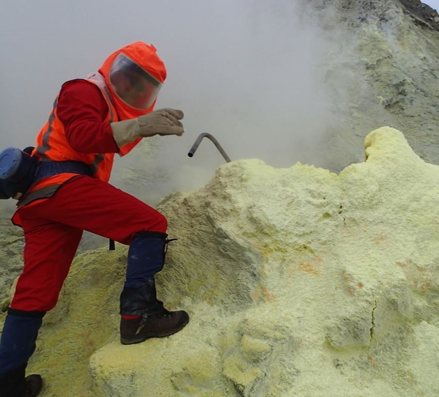
Scientist collecting gas samples from one of the high temperature fumaroles.
Credit: Geonet New Zealand
- New Zealand’s GeoNet team continuously monitors many of New Zealand’s volcanoes, including Whakaari.
- The White Island volcano began showing unrest weeks before the eruption.
- Starting in October 2019, seismicity and sulfur dioxide emissions reached levels not seen since 2016.
- The alert was raised to level 2 on November 15, and, in early December, Whakaari began ejecting gas and mud up to 98 ft (100 m) skyward.
- On December 3, less than a week before the fatal eruption, GeoNet issued a statement saying: “Observations and data to date suggest that the volcano may be entering a period where eruptive activity is more likely than normal.”
- The eruption that occurred on December 9 was followed by minor emissions of ash on December 23 and 26 but no further eruptions occurred.
- Lava has since filled the vents that opened during the eruption on December 9.
- The island is closed to land-based tours now and for the foreseeable future.
- Lawsuits are expected to go to court in 2023 regarding responsibility for the tragedy.
- In response to the tragedy, scientists in New Zealand have been working on the problem of better pinpointing the timing of eruptions on the island using 40 years of hindsight.
- Researchers developed machine learning techniques to characterize specific seismic tremor signals that tend to precede Whakaari’s eruptions.
- Looking backward into 40 years of seismic data and eruptions, they found a characteristic pattern at Whakaari when seismic tremors at depth exceed those near the surface, indicating vigorous fluid movement in the subsurface that is sealed from the surface.
- An initial pulse probably indicates magma movement that heats the hydrothermal system. Then, similar to a pressure cooker, pressure builds up and the superheated gases eventually break through the seal explosively.
- This precursor pattern began with a four-hour energy burst 17 hours before the 2019 eruption and 30 hours before the 2013 eruption. Lesser signals occurred before two eruptions in 2012. The fifth eruption was much shallower, so the signal for that event is under investigation.
- For Whakaari, development of this seismic tremor pattern suggests a one in twelve chance of an eruption within the next five days. This system would have helped forecast the timing of four out of the past five major eruptions, enhancing the existing tools in use by GeoNet for the VAL early warning system.
- Future research will focus on adapting the approach for similar phreatic volcanoes, but each hydrothermal system is different, so the technique must be customized for each site.
- For some volcanoes, understanding precursors may help to prevent future tragedies, but for others, the timing may be too short to help—the precursor signals before the fatal eruption at Mount Ontake in 2014 would have provided only seven minutes of warning for the six-hour round trip hike.
- You may ask if it is ever safe to visit a volcano, and now you probably understand that the answer is that no active volcano is completely safe.