In other EarthDates, we’ve talked about how water can shape Earth’s surface.
It erodes mountains, slowly leveling them over millions of years.
It fills aquifers, and when those are drained too much or too rapidly, the surface of the land above them can sink.
But another way water can shape the land is simply by weighting it down. And when billions of tons of water evaporate from a mountain range or inundate a city, the land can rise or fall.
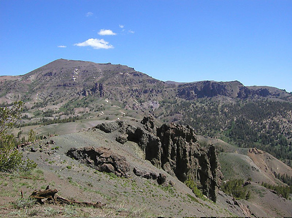
California suffered a severe drought from 2011 to 2015. Scientists studying its effect on the landscape surveyed the Sierra Nevada range using sophisticated GPS.
This technology can detect changes in elevation of just 1 mm. It revealed that the mountain range, which had lost 10 cubic miles of water to evaporation, rose 1 inch during the drought.
Conversely, researchers studying the effects of Hurricane Harvey found that it dumped 20 cubic miles of water on Texas and Louisiana that weighed more than 100 billion tons.
This caused the Earth to sag beneath its weight, up to an inch depending on the amount of floodwater.
They found that they could even trace the path of the storm over the land by following the surface depressions left behind it.
As Harvey’s floodwater drained into the Gulf of Mexico, GPS measurements showed the surface slowly rebounding to pre-flood levels.
Background
Synopsis: Earth’s surface is surprisingly sensitive to short-term changes in the weight of water, both on it and in it. During historic droughts from 2011 to 2015, parts of the Sierra Nevada range grew an inch (2.5 cm) as the amount of water in the rocks decreased by the amount of water Los Angeles uses each year. During flooding related to Hurricane Harvey in 2017, parts of Houston sagged nearly an inch (2.1 cm) under the weight of an inundation equivalent to the volume of Lake Champlain.
- Earth’s surface is very dynamic. Water can change the elevation of Earth’s surface in a few different ways.
- Water erodes mountains and deposits sediments in basins.
- Aquifers are partly supported by the water within them, so removal of too much water can cause them to “deflate,” resulting in ground subsidence above them.
- Loading Earth’s surface with weight causes it to bow downward—somewhat like a trampoline. Unloading the weight enables the surface to “rebound” to its previous shape. (In a previous EarthDate, we talked about how the weight of Pleistocene ice sheets depressed Earth’s surface and is still causing elevation changes.)
- Global Positioning System (GPS) measurements have become more and more sensitive and reliable as technology has improved. Researchers have deployed thousands of GPS stations that record minute changes in the 3D location of Earth’s surface; some networks can measure changes as small as 1 millimeter.
- Scientists use GPS systems to monitor movement of Earth’s surface in areas prone to natural disasters, especially near active faults, landslide areas, and volcanoes. They also use GPS to keep track of natural processes like subsidence related to snowpack loading or groundwater withdrawal.
- Wireless technologies make it possible to monitor changes on a real-time or daily basis, critical for swiftly unfolding natural hazards.
- Rapid data processing provides essential information that can be used to track and respond to natural disasters while they are occurring.
- From 2011 to 2015, California suffered through drought so severe that elevations changed in the Sierra Nevada range. With 11 years of detailed GPS data from 1,300 stations available, scientists investigated what happens to mountain elevation during the drought.
- By measuring elevations in the Sierra Nevada range each October of successive years, scientists found that during the drought of 2011–15, the range grew taller by 1 inch (2.5 cm).
- They determined that 70 percent of the change came from water loss in the mountain range—representing a decrease of 10.8 cubic miles (45 cubic km, 36.5 million acre-feet) of water from the mountains, which is almost the amount of water that Los Angeles uses each year. Of the remainder, 20 percent came from regional changes related to groundwater pumping and 10 percent came from ongoing tectonic uplift.
- Two years later, an increase of snowpack and rainfall resulted in the mountains dropping back down ½ inch (1.25 cm)—half of the elevation they had gained through drought desiccation.
- In August 2017, Hurricane Harvey left devastation in its wake, and so much water that Earth’s lithosphere sagged below it.
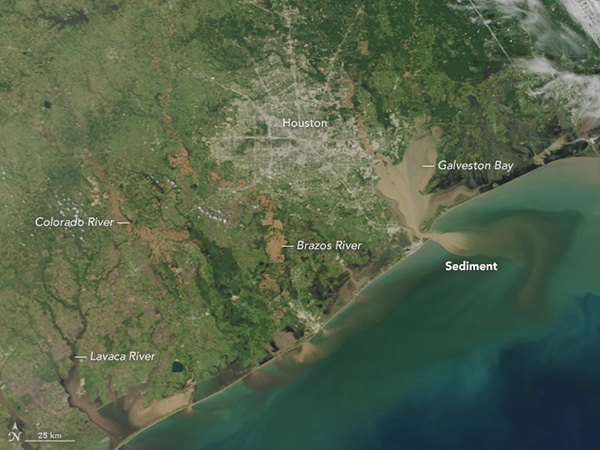
The rivers and bays around Houston run brown with sediment load on August 31, after Hurricane Harvey dumped more than 50 inches of rain on parts of the region. Credit: NASA Earth Observatory - Hurricane Harvey dumped about 127 billion tons of water (22.8 cubic miles, 95 cubic km, 77 million acre-feet) on Texas and Louisiana.
- In just 5 days, some Houston neighborhoods received 51 inches of rain (130 cm), a North American record.
- Six cubic miles (25 cubic km, 20 million acre-feet) of storm water pooled in Houston neighborhoods—about the amount of water in Lake Champlain.
- As the rain fell, GPS systems showed that the ground began to subside almost immediately under the tremendous weight of the water.
- Separate surveys of GPS networks of 477 and 219 stations showed that the surface was depressed an average of 0.4 inches (1 cm), with the highest impact areas ranging from 0.7 to 0.8 inches (1.8 to 2.1 cm), respectively.
- Researchers were able to see the trail of the storm from Texas into Louisiana as the land progressively sank beneath the moving floodwater.
- Much of the floodwater flowed to the Gulf of Mexico over a few days; the rest ended up in Houston’s humid atmosphere via evapotranspiration over the following 3 weeks, during which GPS showed that the ground rebounded gradually to its original configuration.
- Rainfall amounts can be predicted by meteorological reports, but to understand flood risk, disaster teams need to know where the water will go.
- GPS tracking can be used to predict the volume of floodwater that will move downstream as it proceeds along waterways toward the sea.
- This kind of information helps reservoir managers prepare for the arrival of floods by releasing water ahead of the flood to stay within safety limits and storage capacities for their dams.