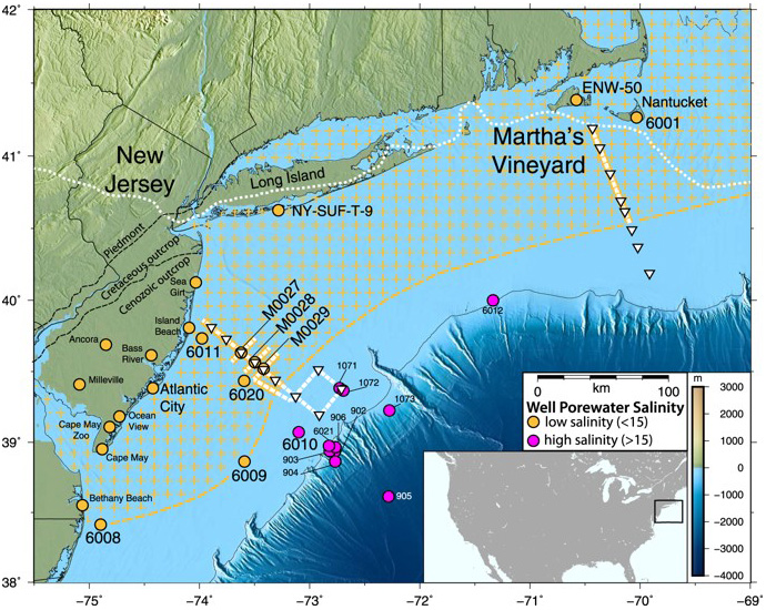
Scientists have identified signs of a huge aquifer off the U.S. Northeast coast (gold hatched area). Onshore and offshore wells that encountered water in the unit are shown as circles, yellow where fresher and pink where more saline. Solid yellow or white lines with triangles show ship tracks. Dotted white line near shore shows edge of glacial ice sheet that melted about 15,000 years ago. Further out, shown in dark blue, the continental shelf drops off into the Atlantic abyss. Credit: Chloe Gustafson, Columbia University, 2019
In the 1970s, engineers drilled a series of wells off the U.S. Atlantic Coast, looking for oil. Instead they found water. Fresh water.
Puzzled, they wondered if they’d found isolated pockets or a continuous aquifer.
Thirty years later, a new technology arrived to help answer this question. Electromagnetic imaging could read the electrical conductivities of subsurface fluids to identify them.
Saltwater is very conductive. Oil and fresh water are not.
They surveyed the same area, and what they found astonished them: a freshwater aquifer 600 ft thick, stretching from New Jersey to Massachusetts, extending more than 50 miles out from the shore.
Geologists set to work to determine where it had come from.
At the peak of the last Ice Age, much of Earth’s water was locked up in continental ice sheets, causing sea level to drop 400 ft—exposing most of the Atlantic continental shelf.
As the climate naturally warmed and the ice receded, meltwater flowed for thousands of years into sedimentary rocks of the continental shelf, charging them with water.
When the rate of glacial melt slowed over the last few thousand years, sediments deposited on the seafloor sealed the aquifer beneath them.
This huge reserve of Ice Age glacial melt could one day supply fresh water to the Eastern U.S.
And it has led scientists to probe other continental shelves, to see if they, too, hold large stores of fresh water.
Background
Synopsis: Researchers have identified a huge, relatively freshwater aquifer beneath the Atlantic seafloor that stretches from New Jersey to Massachusetts—possibly the largest known subsea aquifer in the world.
In the early 1970s, a number of wells drilled off the Atlantic coast into the continental shelf encountered shallow fresh water. (Fresh water has a salinity of 0–1.0 percent, seawater has a salinity of about 3.5 percent, and water in between is called brackish or saline.)
In 1976, the USGS Atlantic Margin Coring (AMCOR) project cored a series of shallow boreholes in the area, finding fresh water (0.1 percent salinity) more than 7 miles off the shore of Maryland and southern New Jersey, and slightly saltier water (0.3 percent salinity) up to 75 miles (120 km) from the New Jersey shore.
For the next couple of decades, additional wells were drilled as oil companies tested deeper targets in the failed search for oil and gas on the Atlantic shelf, and as scientific expeditions drilled along the edge of the shelf where the continental slope drops off into the Atlantic abyssal plain.
In 2009, Integrated Ocean Drilling Program (IODP) Expedition 313 drilled a well about 30 miles (50 km) from the New Jersey shore, discovering about 600 ft (183 m) of freshwater aquifer in fine-grained sediments of early to middle Miocene age (15–19 million years old) about 600–1200 ft (183-366 m) below the seafloor.
Additional wells stepping farther and farther offshore found similar units with progressively saltier water.
About 20 years ago, scientists started using electromagnetic imaging technology (EMIT) to look vertically below the seafloor in the search for deeper oil and gas deposits.
EMIT was developed in the 1980s to study oceanic lithosphere and later adapted for use in hydrocarbon exploration.
Conductivity is the opposite of resistivity. While saltwater is highly conductive, oil and fresh water are the opposite—both are highly resistive to electrical current, so they stand out on electromagnetic surveys, similar to the way bones stand out on X-rays.
Geophysicists also used technology to better understand the distribution of shallow freshwater zones found back in the 1970s in wells ranging from Massachusetts to the New Jersey shelf.
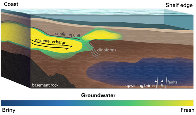
Conceptual model of offshore groundwater. Offshore low-salinity aquifers are fed by adjacent onshore hydrologic system and are vertically constrained by a confining unit until clinoform structures are present. Low-salinity water is also present above the clinoforms and may originate from the larger low-salinity aquifer. High-salinity groundwater exists deeper and farther seaward and is caused by groundwater interaction with underlying salt deposits. Arrows denote groundwater flow paths. Credit: Chloe Gustafson, Columbia University, 2019In 2015, scientists from Columbia University’s Lamont–Doherty Earth Observatory and the Woods Hole Oceanographic Institution launched the Lamont–Doherty research vessel (R/V) Marcus Langseth to survey the Northeastern U.S. coast.
Controlled-source electromagnetic (CSEM) surveying is most responsive to resistive features that do not conduct electrical current, while passive-source magnetotelluric (MT) methods are more sensitive to units that are better conductors. Together, these two technologies produce a more robust conductivity/resistivity profile.
Two continuous 80-mile (130-km) transects were run from shore to shelf edge off the shore of central New Jersey and, 220 miles (350 km) away, off the shore of Martha’s Vineyard, Massachusetts. The New Jersey electromagnetic survey followed the same track as a preexisting seismic survey, and intersected three cores from IODP Expedition 313.
These CSEM/MT surveys incorporated receivers deployed on the seafloor along with a surface-towed system to investigate the characteristics of the subsea aqueous systems within the continental shelf sediments.
Researchers found large, continuous, seaward-dipping resistive zones that tied directly to the fresher groundwater zones from IODP Expedition 313 and other wells in the area—suggesting that the nearly fresh water occurs as a huge continuous aquifer, not just in scattered pockets.
In profile view, the low-salinity electromagnetic signatures begin around 600 ft (183 m) below the seafloor and continue down to about 1,200 ft (366 m), spanning an area from the shoreline out to about 56 miles (90 km).
Resistive zones in the offshore New Jersey survey follow geologic boundaries evident on the seismic line and corroborated by geologic units identified in the IODP cores.
In map view, the consistency of data from the two surveys led researchers to infer that the nearly freshwater aquifer is likely to be continuous for the 220 miles (350 km) between the New Jersey and Massachusetts datasets—and probably extends beyond the surveys in both directions.
How did a giant reservoir of fresh water end up under the Atlantic Ocean?
The water resides in Miocene sedimentary rocks that are 15–19 million years old, but age dating shows that the aquifer water probably accumulated during repeated Pleistocene sea-level lowstands.
The most recent recharge event is thought to have occurred after the Last Glacial Maximum. About 20,000–25,000 years ago, much of Earth’s seawater was locked up in mile-thick continental glaciers that covered 25 percent of Earth’s land area. (Glaciers now cover about 11 percent of the land surface.)
Continental ice sheets rendered sea level as much as 400 ft (120 m) lower than it is today, driving the Atlantic Ocean coastline to the edge of the continental shelf, where the continental slope drops off abruptly toward the abyss.
The southernmost extent of the ice sheet tracked through onshore central New Jersey then ran along today’s shoreline from the New Jersey–New York state line in Raritan Bay to Nantucket Island in Massachusetts, where the edge trended offshore (dotted white line on map).
As the massive continental ice sheet began melting 15,000 years ago, fresh water inundated the sediments exposed between the glaciers and the sea.
Once sea level reached its current height about 8,000 years ago, fresh water was trapped as “fossil water” beneath younger glacial and marine sediments that sealed the aquifer.
Hydrogen and oxygen isotope data show that modern water from rainfall, lakes, and rivers also recharges the aquifer, which is likely drawn seaward by tidal pumping—the rising and falling pressure of tides on the sediments.
The aquifer is a great resource for the growing, thirsty population of the U.S. Atlantic Seaboard.
The freshest water in the aquifer is closest to shore, with a typical freshwater salinity of only about 0.1 percent. Toward the outer edges of the aquifer, salinity reaches 1.5 percent, which is considered brackish but still much fresher than seawater at 3.5 percent.
The brackish water would need desalination, but the cost would be less than seawater because of the lower salinity.
Additional research on this aquifer and more extensive mapping of other potential offshore aquifers needs to take place in order to understand how much groundwater may be hidden on Earth’s continental shelves.
Recently, groundwater reserves have also been located along the Norwegian coastline.