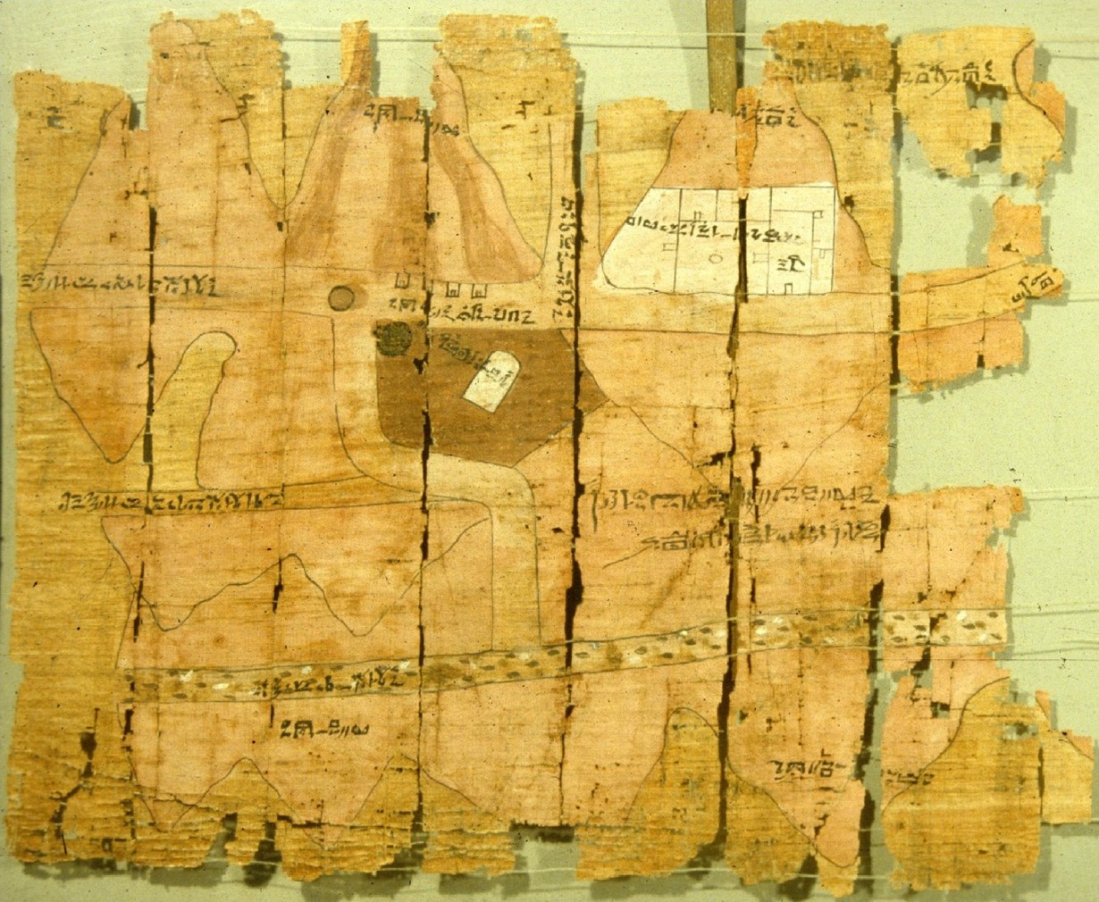
Credit: TurinPapyrus1.jpg, public domain (PD-US), via Wikimedia Commons
In the early 1800’s, Napoleon’s emissaries in Egypt discovered an ancient map.
Records from the time showed it came from a tomb, in the village of Deir el-Medina, the traditional home of craftsmen who had worked on the temples of the pharaohs in ancient Egypt.
Later studies revealed this particular map was drawn around 1150 BC, in the characteristic handwriting of Amennakhte, the official “Scribe-of-the-Tomb.” And it showed something marvelous.
It recorded the geologic features of Wadi Hammamat, the “Valley of Many Baths,” and apparently was created for pharaoh Rameses the IV, to help plan mining expeditions to the area.
This is because the wadi was the Egyptians’ sole source for bekhen-stone, the nearly black, fine-grained greywacke used for many of their greatest statues carved between 3000 BC and 400 AD, and still admired today.
In the amazing map, Amennakhte had invented a graphical language to represent strata layers, rock types, topographic lines, faults and other features, very similar to geologic maps made today.
In fact, modern scientists have returned to the wadi with his map to find that it pictures the area accurately enough to be used today.
Just how significant was this? The next known geologic maps were drawn some three thousand years later.
Amennakhte was clearly an Earth scientist way, way ahead of his time.
Background
Synopsis: The world’s oldest geological map ever found was drawn around 1150 BC to document an expedition by a pharaoh to retrieve building stone in Egypt. The next oldest preserved geological map was drawn nearly 3,000 years later. On the ancient Egyptian map, hills are illustrated in relief and different geological units are shown in different colors and patterns. The target of the expedition appears to have been Precambrian metamorphosed greywacke known as bekhen-stone that was prized for use in statues.
- Geological maps are spatial representations that illustrate geological features.
- Different rock units may be shown in different colors or symbols, or both.
- Contacts between rock units are shown as lines. Sometimes these are lithologic surfaces, but they can also be faults or unconformities (squiggly lines).
- Relief may also be shown on maps using shading or topographic contours.
- The strike and dip of bedding and faults or trend and plunge of folds provide three-dimensional information. Geophysical information and many different rock properties are also commonly illustrated in map form.
- The first geological map of a country, Great Britain, was drawn just over 200 years ago by English geologist William Smith and published in 1815.
- Its story was memorialized in the book The Map that Changed the World, a biography of Smith by Simon Winchester.
- An earlier map of a smaller area was published about 250 years ago by Nicholas Desmarest as part of a study about basalt flows in the Auvergne region of France. This 1771 map is the earliest known geological map from Europe.
- But these historical geological maps were drawn more than 29 centuries after a remarkable map found near the ancient town of Thebes (now Luxor) in Egypt.
- No geological maps from the intervening centuries have been found worldwide, resulting in an archaeological gap of nearly 3,000 years.
- Sometime between 1814 and 1821, the scroll of papyrus was discovered by agents of Bernardino Drovetti, the French consul general in Egypt during the time of Napoleon.
- Records show the map was discovered in a private tomb in the Egyptian village of Deir el-Medina, home to craftsmen who worked on royal tombs in both the Valley of the Kings and the Valley of the Queens during the eighteenth to twentieth dynasties of the New Kingdom of Egypt (1550–1080 BCE).
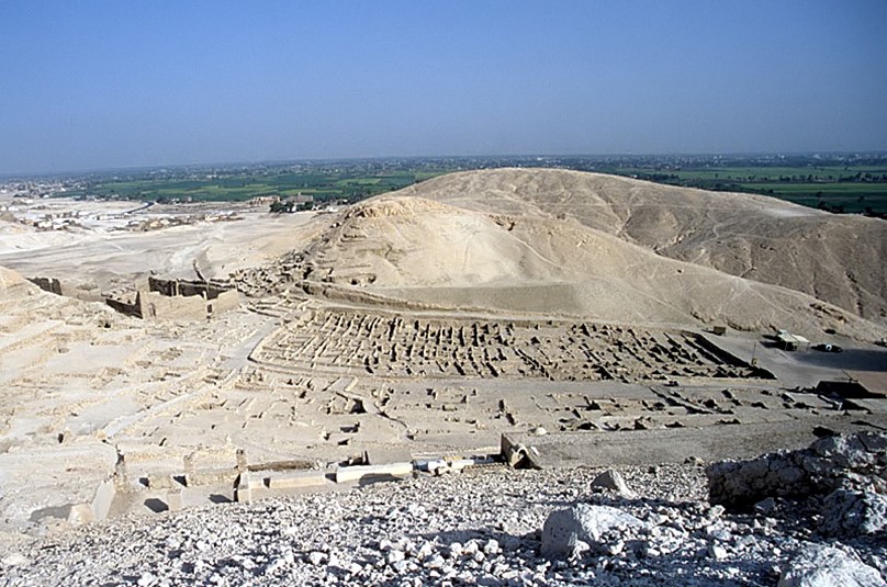
The artisan’s village of Deir el-Medina is located on the west bank of the Nile across the river from the ancient town of Thebes in Egypt. The map was found in a family tomb in the ruins. The home of Amennakhte, the author of the map, was marked by an inscribed door jamb and is located in the middle of the maze of ruins.
Credit: Roland Unger, via Wikimedia Commons - In 1824, the map was sold to King Charles Felix, who established the Egyptian Museum in Turin, the capital of his northern Italian kingdom. The map is still located there.
- Records show the map was discovered in a private tomb in the Egyptian village of Deir el-Medina, home to craftsmen who worked on royal tombs in both the Valley of the Kings and the Valley of the Queens during the eighteenth to twentieth dynasties of the New Kingdom of Egypt (1550–1080 BCE).
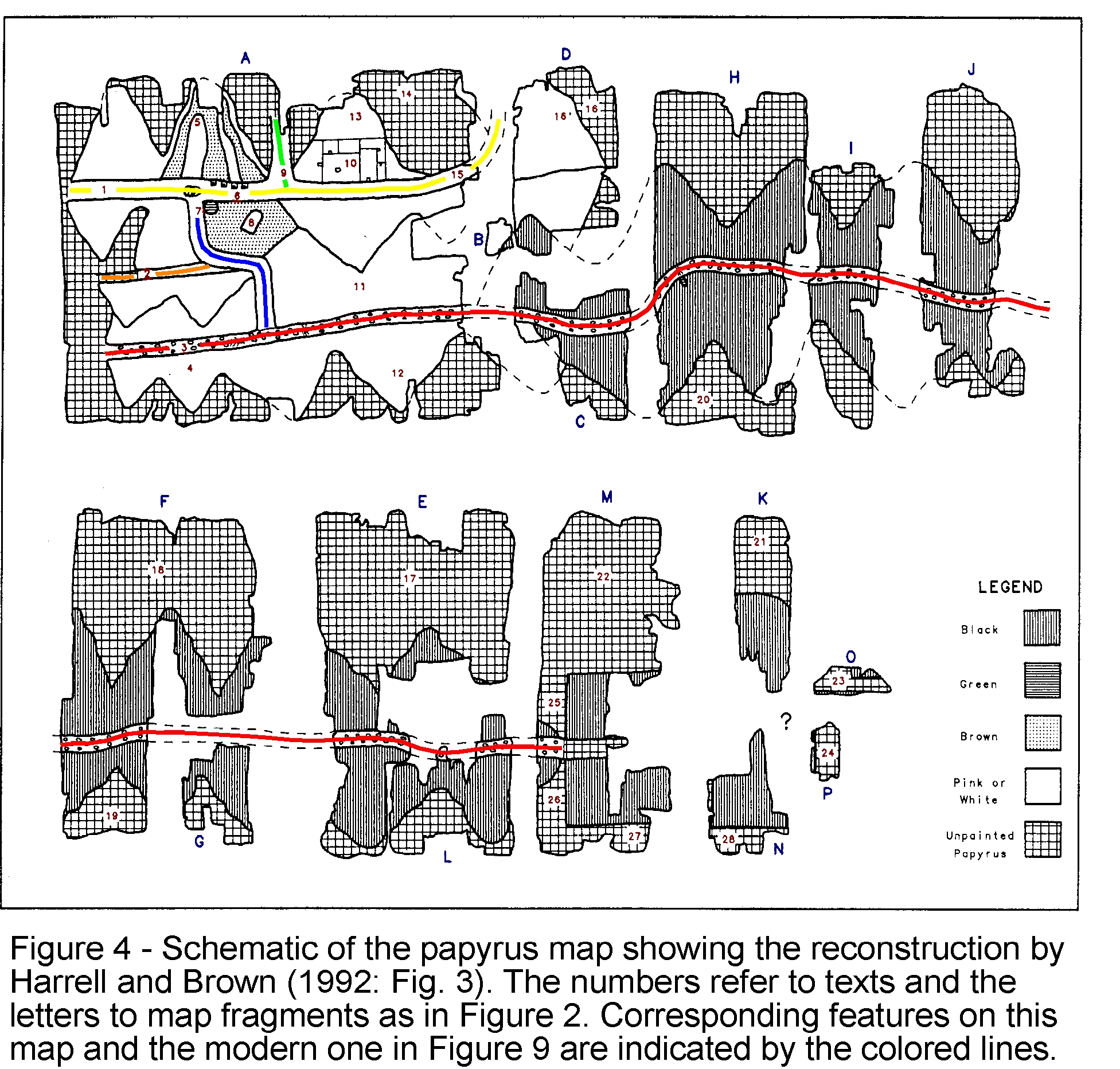
- The ancient Egyptian map was drawn on a roll of papyrus measuring 1 ft 4 in by 6 ft 11 in (41 by 210 cm). An earlier erroneous assembly of the same map was 9 ft 2 in (280 cm).
- The papyrus was rolled when discovered and was damaged during handling leaving the right end tattered and poorly preserved.
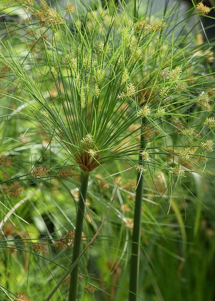
Cyperus papyrus, or Nile grass, is a species of aquatic flowering sedge that grows in swampy shallow fresh water. Strips of the stem are placed side by side, then covered with another layer of strips at right angles, and then hammered to create pages that scribes wrote on using reed brushes dipped in ink made of powdered minerals in liquid.
Credit: Krzysztof Ziarnek, Kenraiz, via Wikimedia Commons - In 1989, University of Toledo geologist Dr. James Harrell and colleagues reassembled the map using the illustrations on the map side, the pattern of papyrus fibers, and writing on the back side of the document to create the shorter 6 ft 11 in (210 cm) map.
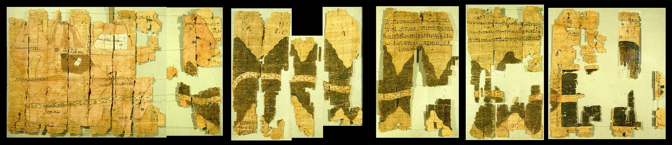
Reassembled fragments of the Turin papyrus.
Credit: (Left and right) Zyzzy, public domain (PD-US), via Wikimedia Commons
- The papyrus was rolled when discovered and was damaged during handling leaving the right end tattered and poorly preserved.
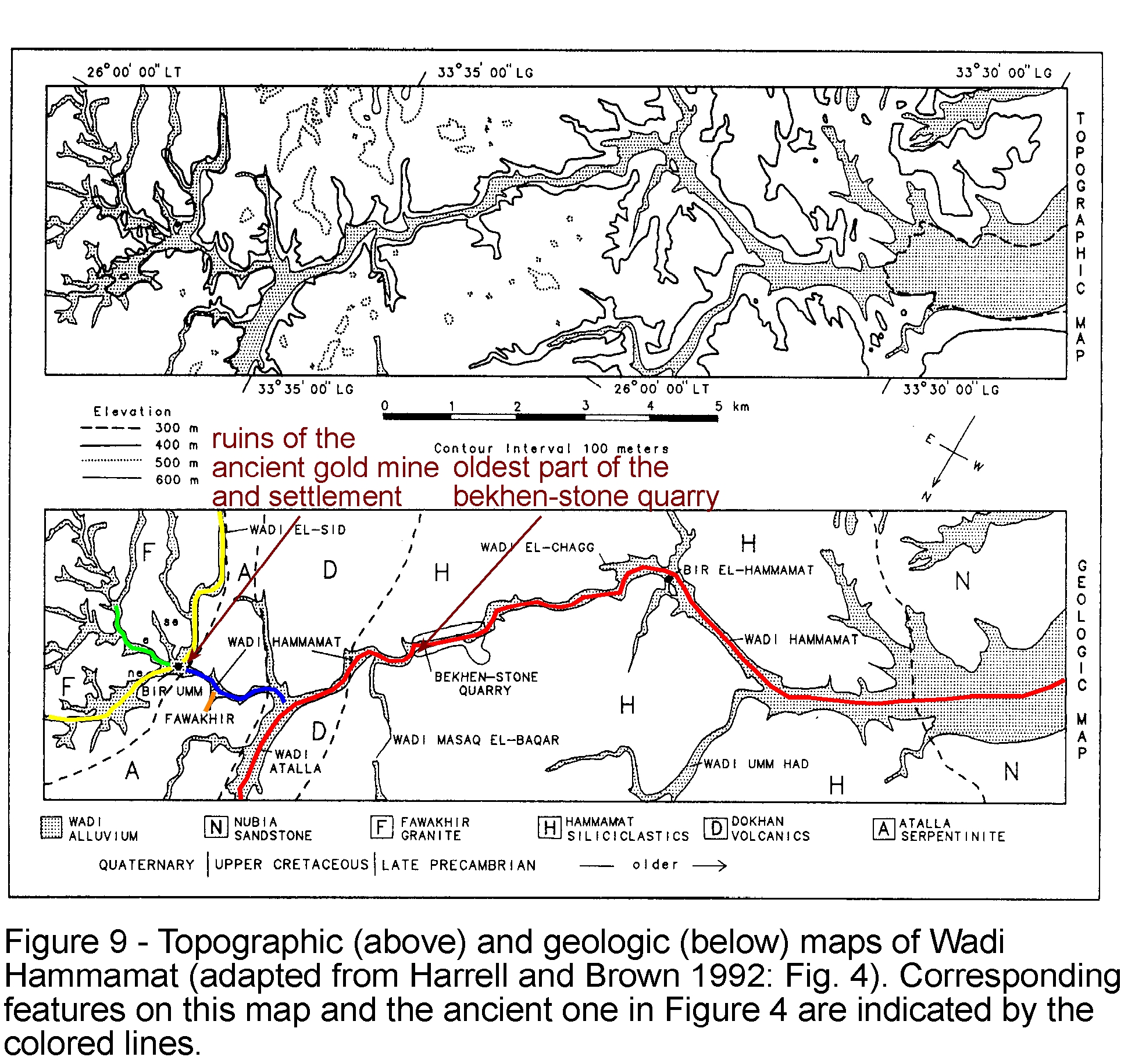
- Dr. Harrell travelled to Egypt to field check the map and determined it was a realistic map of a 9.3 mi (15 km) stretch of Wadi Hammamat including its intersections with two other wadis and correct visual depictions of local geology.
- Wadi Hammamat, the “Valley of Many Baths” is a 125 mi (200 km) valley connecting Thebes to the Red Sea and Silk Road beyond.
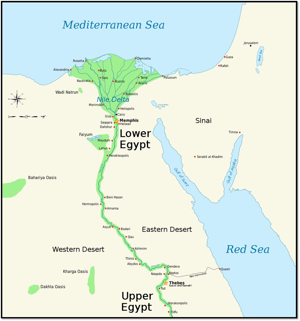
Map of Ancient Egypt, showing the Nile with major cities and sites of the Dynastic period (c. 3150 BC to 30 BC). Modern Cairo and Jerusalem are shown as reference cities. Wadi Hammamat is a well-travelled 125 mi (200 km) connection from Thebes to the Red Sea and the trade routes of the Silk Road.
Credit: Jeff Dahl, via Wikimedia Commons - Historically, the wadi was well-travelled for mining, quarrying and commerce, with three millennia of graffiti on its walls, making it a modern tourist destination.
- Ruins in the wadi range from a 1930’s British mill to a Roman stone fort to a Ptolemaic mining settlement to Egyptian stone tools from the eleventh-century BC.
- Wadi Hammamat, the “Valley of Many Baths” is a 125 mi (200 km) valley connecting Thebes to the Red Sea and Silk Road beyond.
- The Turin papyrus depicts the hills surrounding the valley using colors similar to those found in the wadi for the various rock types.
- Pink colors represent both volcanics, granite and gold-bearing quartz veins; white, brown and speckled green ovals faithfully match the alluvial wadi deposits; yellow colors the sands of the desert; and dark brown denotes the deep greenish-gray chloritic type of greywacke known as bekhen-stone that was especially prized for Egyptian statues.
- You can compare features on the ancient map to modern maps using these links.
- The map shows a gold mine, four small houses for gold workers, a multiroomed temple to the god Amun, a stone monument to Pharaoh Seti I in a brown patch representing either mine tailings or farm fields, a water reservoir, and a water well with the shadow of its wall being cast to the right.
- Farther to the right, the map shows a bekhen-stone quarry across from a drawing of an inverted tree. Wadi Hammamat is the only source for this beautiful rock that was quarried from 3000 BC to AD 400.
- Contrary to modern mapping practices, the top of the map is oriented south toward the source of the Nile, so east is to the left and west is to the right.
- The scale is not constant, but each centimeter on the map represents 164 to 328 ft (50–100 m).
- The ancient Egyptian map is thought to have been created as a visual record for either the pharaoh or the high priest of Amun in Thebes, who would have organized the large expedition to quarry blocks of bekhen-stone to be used for statues of the pharaoh.
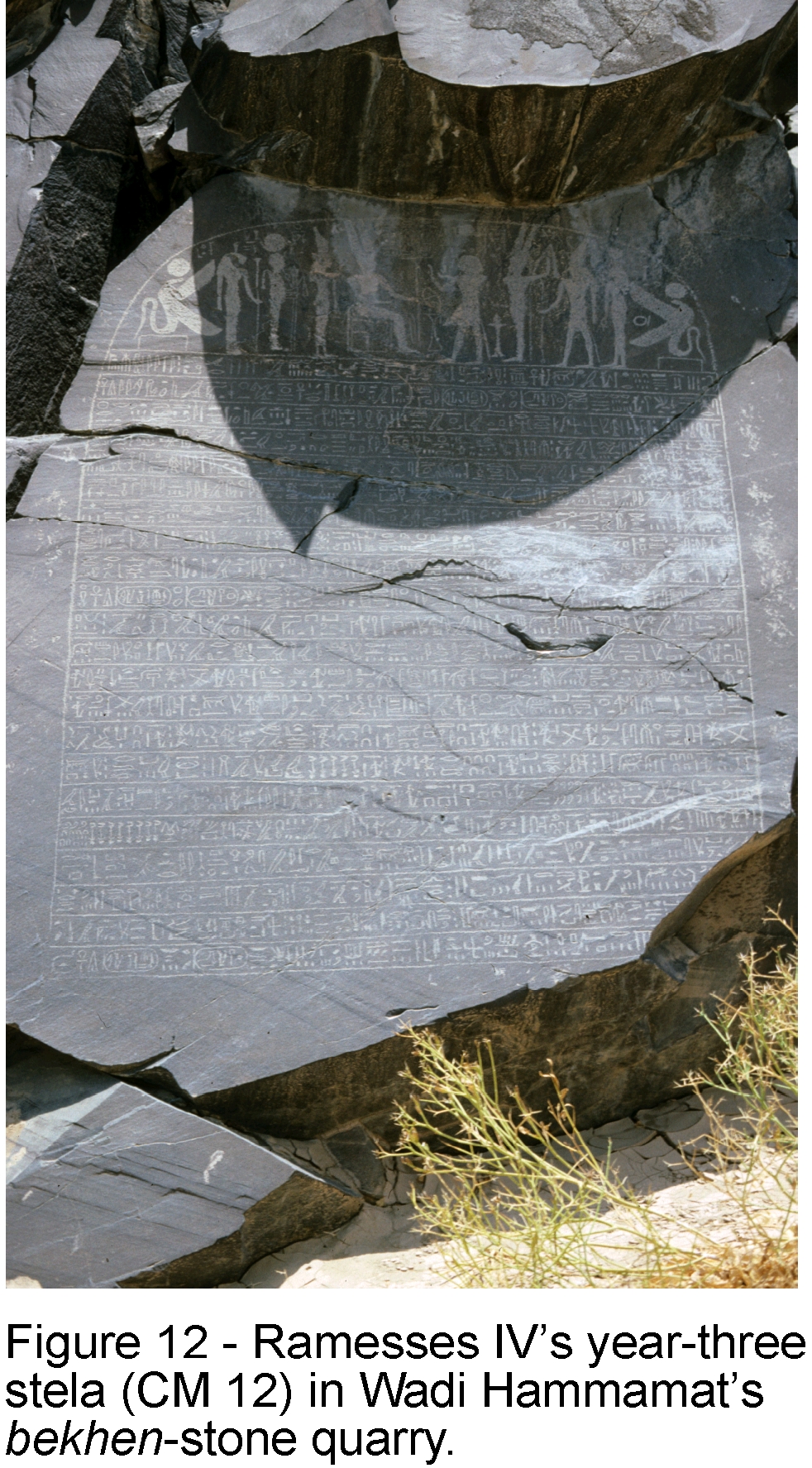
- Ramesses IV, the third pharaoh of the twentieth Dynasty of the New Kingdom of Ancient Egypt, reigned for just over six years and died in 1149 BC at the age of 27.
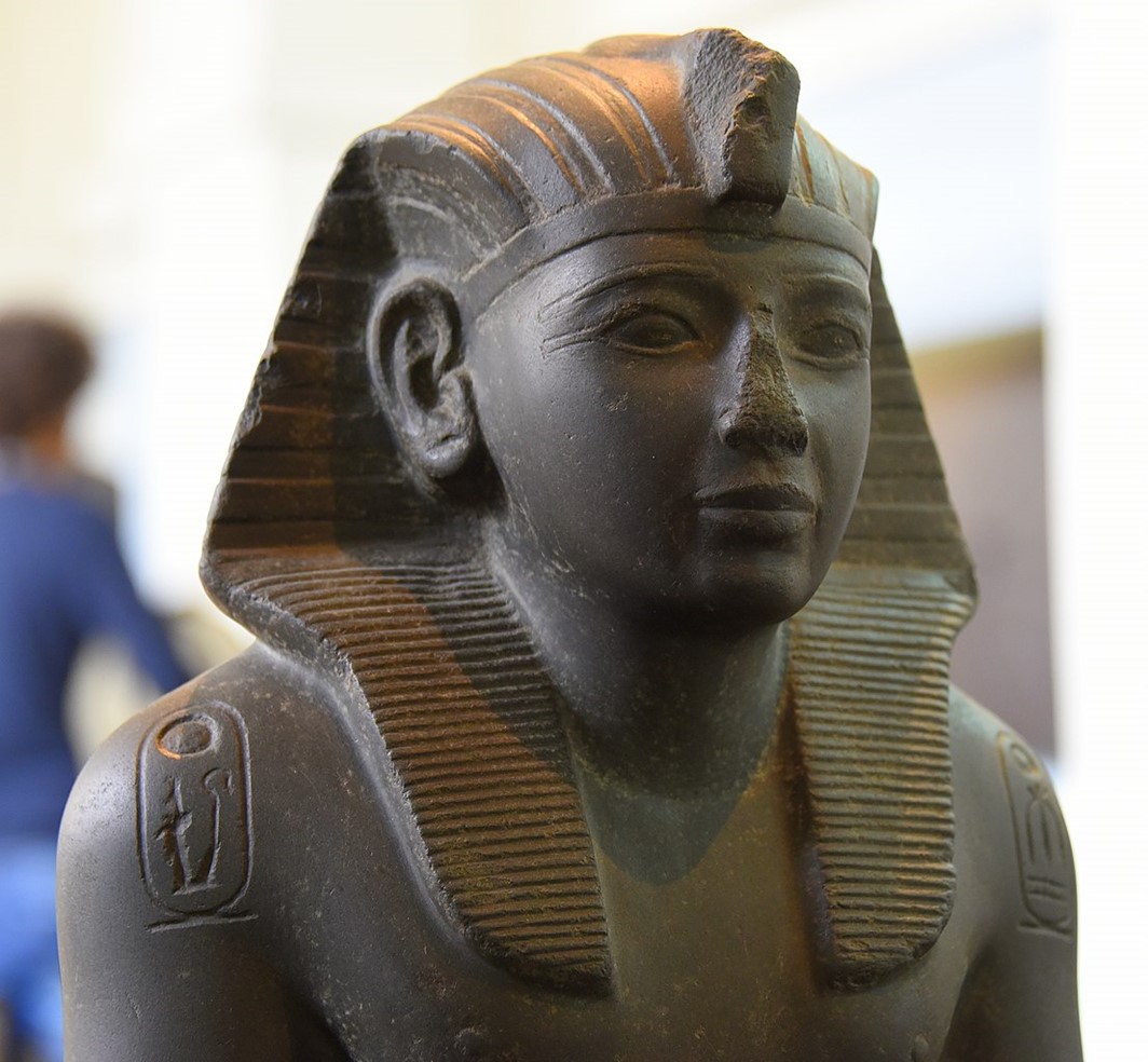
Statue of Ramesses IV in bekhen-stone, with nomen and prenomen (birth name and throne name) cartouches on its shoulders, currently housed in the British Museum, London.
Credit: Osama Shukir Muhammed Amin FRCP(Glasg), via Wikimedia Commons - An inscription at the quarry wall was left by Ramesses IV stating that the expedition occurred in the third year of his reign and included 8,362 men.
- The map was created in the distinctive handwriting of a government official named Amennakhte, chief scribe of the royal necropolis, or “Scribe-of-the-Tomb.”
- The scribe made annotations explaining features and colors used on the map, identifying destinations of the routes in the wadi and the locations of gold deposits, marking distance between the gold mining settlement and the bekhen-stone quarry, and inventorying the sizes of bekhen-stone blocks that were quarried, just like a modern geologist might.
- Amennakhte also served as a civil judge and kept records of natural events like floods. His home was identified by an inscribed door jamb in Deir el-Medina, and it has been confirmed that the map was taken along with other documents from his family tomb.
- The back side of the papyrus was used like scrap paper for younger documents.
- Ramesses IV, the third pharaoh of the twentieth Dynasty of the New Kingdom of Ancient Egypt, reigned for just over six years and died in 1149 BC at the age of 27.