Credit: Tiffany A. Rivera, via Wikimedia Commons
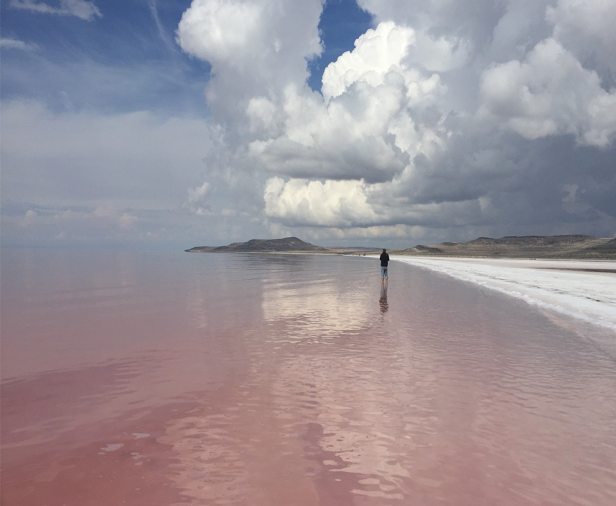
Utah’s Great Salt Lake may seem like a wasteland, ringed by toxic deposits of mercury and arsenic, and filled with water so salty that only brine shrimp can live in it.
However, those shrimp feed 10 million migrating birds. And the lake provides eight thousand jobs and two billion dollars in industry, harvesting salt and other minerals. It’s vital to the region’s ecology and economy.
But the lake is in danger.
Great Salt Lake is the remnant of Lake Bonneville which, in ancient times, was nearly as big as Lake Michigan.
Then, 18,000 years ago, the lake found a drainage path to the Pacific Ocean through the Snake River Valley, and its level fell 400 feet.
Fifteen thousand years ago, as glaciers retreated from the region, the climate became drier. The lake became landlocked again and started to evaporate, falling another 600 feet to stabilize at its modern size.
But over the past century, its been gradually shrinking. In 2022, it hit a record low.
This is due to rising temperatures and drier summers in the region, and, importantly, to lower inflow—as the rivers that feed the lake have been increasingly diverted for agriculture and mining. So, Utah began water conservation measures.
Then 2023 saw the most snowfall in 70 years, which may lead to record runoff.
Only time will tell if Utah’s people, and weather, can save the Great Salt Lake.
Background
Synopsis: Northwestern Utah’s Great Salt Lake is the largest salt water lake in the western hemisphere, but, as drought causes lake levels to drop to modern lows, the shallow lake is shrinking rapidly. It is the remnant of Pleistocene Lake Bonneville, which was more than ten times its size. Today, drought and diversion of water for agriculture could dry the lake within the decade, threatening local health and industry as well as the unique ecosystem surrounding the lake. It has recovered from levels like these before, but will it be able to pull through this time?
- The Great Salt Lake is the largest salt water lake in the Western Hemisphere, and it is the eighth largest in the world when filled to its average level.
- There are only about 30 salt water lakes in the world, all of which occur within closed (endorheic) basins that do not flow out to the sea, making them prone to evaporation with highly variable water and salinity levels.
- For thousands of years indigenous tribes including the Shoshone, Ute and Paiute migrated along the freshwater river and stream canyons along the periphery of the Salt Lake Valley for summer.
- The Shoshone called the lake Ti'tsa-pa, meaning bad water.
- It was indicated on written maps dating back to 1575.
- Nearby Salt Lake City was founded southeast of the lake on July 24, 1847, by Mormon pioneers led to the region by Brigham Young.
- Dramatic changes in water level have shaped the history of the Great Salt Lake, which is a remnant of Pleistocene Lake Bonneville in the bowl-shaped eastern Great Basin.
- Lake Bonneville was 325 mi (523 km) long and 135 mi (217 km) wide, nearly the size of Lake Michigan, covering parts of Utah, Nevada and Idaho.
- It was around 1,000 ft (305 m) deep, with many of western Utah’s present-day mountaintops protruding as islands.
- Although it formed during the Pleistocene Epoch, it did not form by glacial processes and had no river connection to the great ice sheets in the north.
- Evidence of paleo-shorelines in the mountains surrounding the lake reveal that, starting 30,000 years ago, the level of Lake Bonneville oscillated as it gradually filled with freshwater runoff from adjacent highlands that exceeded evaporation in the closed basin.
- When it reached its highest water level around 18,000 years ago, it began to trickle, then surge through sediments damming Idaho’s Red Rock Pass in an enormous flood rushing down the Snake River to the Pacific Ocean, dropping lake level by more than 400 ft (120 m) in just a year.
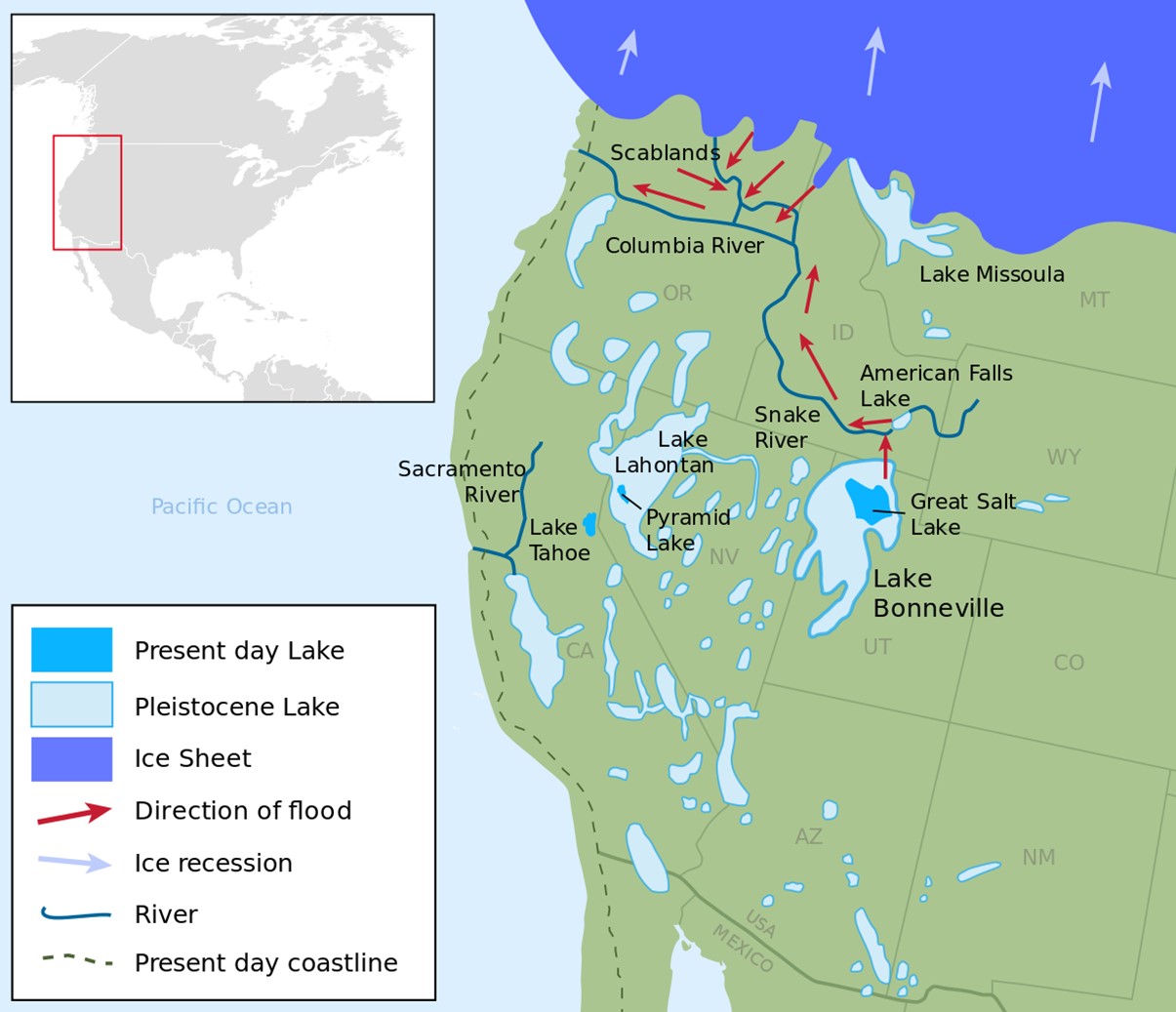
Lake Bonneville and other Late Pleistocene paleolakes in the Great Basin during the last major global glaciation. The red arrows show the path of the Bonneville Flood through the Snake River Valley with some contemporaneous but unrelated floods illustrated from Lake Missoula in eastern Washington.
Credit: Fallschirmjäger, via Wikimedia Commons - The lake stabilized and continued outflow to the Pacific through the Snake River Valley for another 3,000 years.
- Then, 15,000 years ago, the climate became drier, closing off the basin. In just 2,000 years evaporation caused the lake level to drop more than 600 ft (180 m) to about its present-day average level. Trace amounts of dissolved salts in the huge lake were concentrated by the intense evaporation, turning the lake saline.
- Prior to the filling of Lake Bonneville 30,000 years ago, filling and drying of the closed basin may have cycled repeatedly for as much as 800,000 years.
- Today the lake basin is fed by the Bear, Weber and Jordan Rivers that drain the Wasatch, Uinta and Oquirrh Mountain Ranges, with a catchment area of about 21,500 sq mi (56,000 km2)—almost the size of the state of West Virginia.
- Each year more than a million tons of dissolved salts leached from salt-rich sediments in the surrounding basin are delivered to the hypersaline Great Salt Lake by inflowing streams and rivers.
- Lake-effect snow—produced as north, northwest or west winds blow across the warmer lake water—accounts for 10% of the precipitation in the mountains east of the lake, supporting a thriving ski industry.
- The Great Salt Lake is very shallow with an average depth of just 16 feet (4.9 m), so small changes in lake level cause major changes in the areal extent of the lake.
- The water level of the Great Salt Lake at both Corinne and Ogden has been recorded since 1847, with additional sites added over time.
- An average year of snowmelt can increase lake levels by 2 ft (0.6 m) in the spring, while a summer of evaporation can consume 3 million acre-ft (3.7 km3), nearly 1/5 of the average volume of the lake each year (which can be offset by fluvial inflows).
- Winter 2022–2023 snowfall was the highest in 70 years, so snowmelt may set a new record.
- Sixty years ago (1963) the lake shrank to half its typical size. Then, almost forty years ago (1986), it nearly doubled its normal areal extent. But for most of the past four decades, water levels have been falling and the surface area has been shrinking in Utah’s Great Salt Lake. In November 2022, the lake level dropped to 3 ft (0.9 m) below the 1963 record low, creating major concerns for health, industry and ecosystems in the region.
- At its historic average level of 4,200 ft (1,280 m) above sea level, the lake is about 75 mi (121 km) long and 28 mi (45 km) wide with a surface area of about 1,700 sq mi (4,400 km2) and a volume of 15.4 million acre-ft (18.92 km3). When it is at this level it has 335 miles of shoreline, and its maximum depth is just 33 ft (10 m).
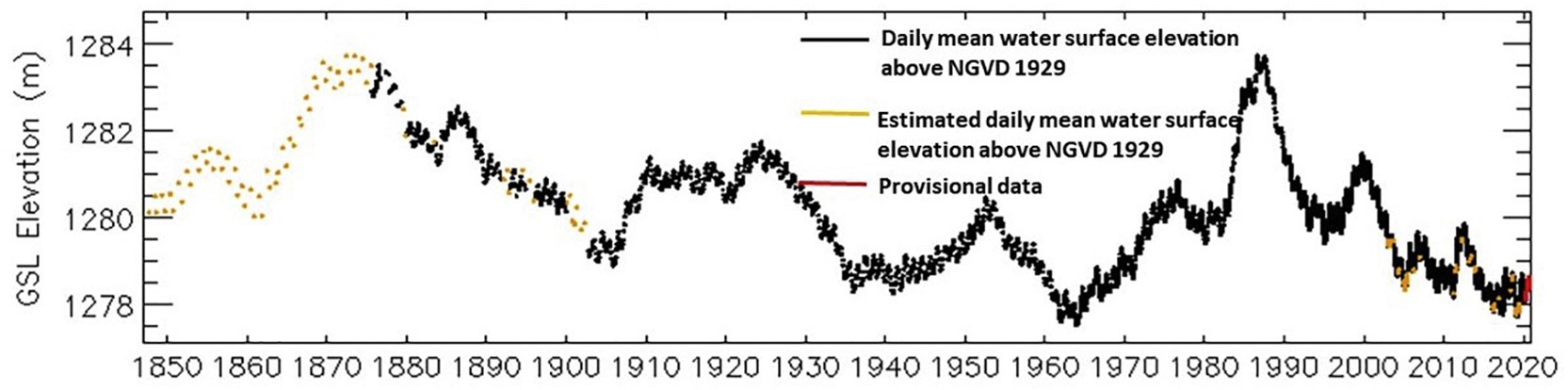
Annual water level of the Great Salt Lake at Saltair Boat Harbor for 1847 to 2020. By November 7, 2022, the water level had dropped to an all-time measured low of 4,188.3 feet (1,276.6 meters), off the bottom of this graph.
Credit: USGS - In October of 1963, drought drove the lake level down by just 8.6 ft (2.5 m) to 4,191.4 ft (1,277.5 m), reducing its area to 950 sq mi (2,460 km2), just 56% of its normal size.
- Then, in June of 1986, several years of high precipitation and snowmelt runoff increased its average water level by about 12 ft (3.7 m) to 4,211.6 (1,283.7 m), nearly doubling the lake’s surface area to 3,300 sq mi (8,546 km2). This higher level had also been achieved in the historically wet summers of 1872 and 1873.
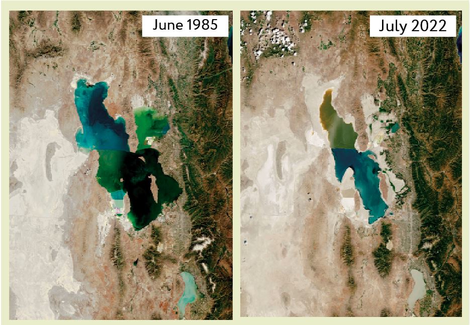
The Landsat image to the left was acquired in June 1985 and shows the lake when water elevation levels were unusually high due to a string of years with heavy rains and large amounts of runoff from melting snow. The Landsat image on the right from July 2022 shows the lake when water elevation levels neared a record low, exposing around 2,350 square miles of the lake bottom compared to 1985. Note the 2022 difference in colors between the northern and southern portions of the lake, which was the result of restriction of flow by an east–west railroad causeway installed in 1959. North of the causeway there are no water inflows so the salinity is roughly doubled and red algae thrive.
Credit: NASA Earth Observatory - In November of 2022, the lake set a new record low level at 4,188.3 ft (1,276.6 m), nearly 12 ft (3.6 m) below average for the lake. Even the deepest spot in the lake was just 22 ft (6.7 m) deep, and 71% of the area the lake covered in the 1980’s was exposed to windborne erosion—that’s about the size of the state of Delaware.
- Since 2020, the volume of the lake has dropped by about 1 million acre-ft (1.23 km3) per year.
- At its historic average level of 4,200 ft (1,280 m) above sea level, the lake is about 75 mi (121 km) long and 28 mi (45 km) wide with a surface area of about 1,700 sq mi (4,400 km2) and a volume of 15.4 million acre-ft (18.92 km3). When it is at this level it has 335 miles of shoreline, and its maximum depth is just 33 ft (10 m).
- While cycles of filling and evaporation may be natural in the basin, human impact in the region has added a new set of variables to the equation, raising concern around the latest drying trend.
- Lake level has been shown to be modulated by patterns of Pacific Ocean events using 750 plus years of tree ring data, so scientists at the Utah Climate Center use these patterns along with lake level and precipitation trends to predict the lake level about five to eight years into the future. Current predictions suggest that there is no large wet Pacific weather system waiting in the wings to save the day, as occurred in the 1980’s.
- The amount of precipitation that falls in Utah as snow, “stored” as snowpack in the mountains, has been decreasing for a few decades. This impacts melting, which provides water in the spring and summer (ED-206 The Value of Snowpack). Lower proportions of precipitation falling as snow have been shown to correlate with increased desiccation of the lake basin.
- Like many other western cities, Salt Lake City is growing, with a population that has nearly doubled in the past 40 years. Over the past century, nearly 40% of Wasatch Front water has been increasingly diverted away from the lake, about 74% of that for agriculture (principally alfalfa and hay) and 9% for mining.
- The lake supports a unique ecosystem with diverse wildlife population, with marshes that account for 80% of Utah’s wetlands. Increasing salinity in the lake is threatening the whole ecosystem as green algaes give way to red algaes, changing the base of the food chain and challenging brine shrimp populations that sustain the more than 10 million birds that migrate through the region. This is already obvious in the northern arm of the lake.
- Dry lake bed sediment contains toxic dust that includes mercury, lead, antimony, copper, zirconium and arsenic that could be carried by the wind to damage crops, degrade soil, cause premature snowmelt and increase illnesses like asthma, bronchitis, heart disease and cancer.
- The lake contributes around 7,700 jobs and $1.9 billion to Utah’s economy each year through brine shrimp and salt harvesting, potash, lithium and magnesium mining, and recreational activities such as skiing.
- The state of Utah has “all-hands-on-deck” to address the drying of the lake through water management and conservation. Some scientific studies speculate that without coordinated action the Great Salt Lake ecosystem could collapse.