Credit: NASA JSC ISS image library, via Wikimedia Commons
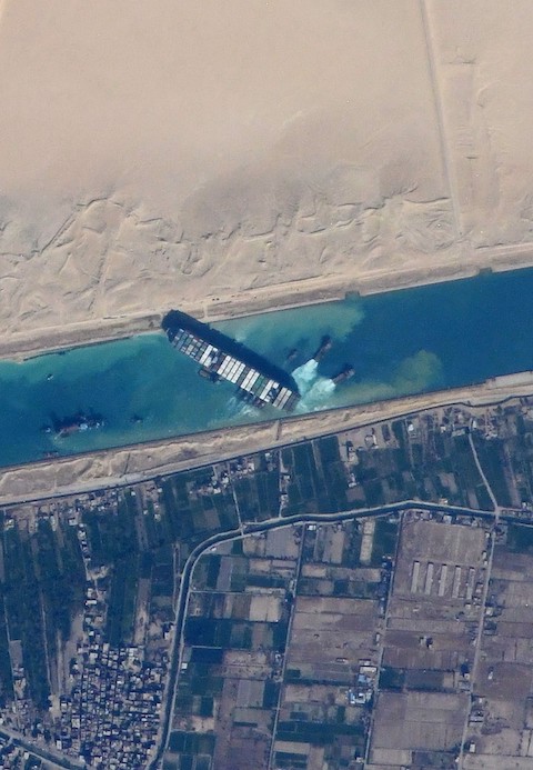
In March 2021, a huge container ship was blown sideways by a sandstorm and jammed diagonally in a narrow stretch of the Suez Canal, blocking it entirely.
Because 12% of all global trade moves through the canal, experts calculated its closure was costing the global economy $400 million per hour!
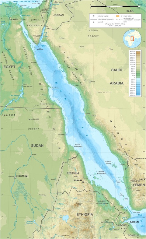
The Suez Canal is really just an extension of the Red Sea, a narrow, 1,200-mile-long strip of water that began opening 20 million years ago between North Africa and Arabia.
It almost connected the Indian Ocean and the Mediterranean Sea naturally but fell 120 miles short.
In the 1860s, 1.5 million workers spent a decade digging that last 120 miles: a narrow canal that connects several natural lakes, which today serve as harbors.
Nearly 20,000 cargo ships and tankers now take this route each year, a shortcut that avoids an expensive and dangerous journey around the Horn of Africa.
To free the stranded ship, a fleet of tug boats, dredging ships, and salvage divers pulled and dug for six days and nights, working around the clock.
On the seventh day, a rising tide gave just a few more inches of lift, and they finally freed the bow.
Hundreds of waiting ships resumed their trip through the canal, carrying products for millions of people in the region.
Background
Synopsis: In March of 2021, a massive cargo ship became wedged in Egypt’s Suez Canal, blocking one of Earth’s busiest shipping routes. This heavily travelled nautical shortcut from the Indian Ocean through the Red Sea to the Mediterranean Sea is made possible by a combination of plate tectonics and human ingenuity. Rifting that began more than 20 million years ago formed the narrow, 1,200-mi-long (1,930 km) Red Sea rift, while a decade of human construction resulted in the 120 mi (193 km) Suez Canal which started operation in 1869.
- The Al-Baḥr Al-Aḥmar (in transliterated Arabic), or Red Sea, separates North Africa from Arabia, running 1,200 mi (1,931 km) from the Bab-el-Mandeb Strait in the south to the town of Sharm El-Sheikh, at the southern tip of the Sinai Peninsula.
- The widest part of this long, narrow sea is just 190 mi (306 km) across.
- At its north end, the Gulf of Aqaba heads northeast toward the Dead Sea, while the Gulf of Suez continues to the northwest for 180 mi (290 km) more, connecting with the Mediterranean Sea via the Suez Canal.
- The Red Sea’s south end connects to the Indian Ocean by way of the Gulf of Aden.
- Egypt, Sudan, Eritrea and Djibouti flank its western shore, and Saudi Arabia and Yemen form its eastern margin, including mountains as high as 6,560 ft (2,000 m) toward the south.
- It is called the Red Sea because of frequent red algal blooms, although some translations suggest its historical name may have been the Sea of Reeds.
Credit: Eric Gaba (Sting), via Wikimedia Commons
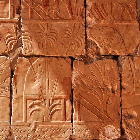
- The Red Sea has been a key trading route for more than 3,500 years.
- The world’s first historical record of maritime travel concerns Egypt’s trading-exploration trips to the mysterious Land of Punt in the southern region of the Red Sea around 1500 BCE.
- Hatshepsut, the second female pharaoh of Egypt, travelled to this mysterious region on the shores of the southern Red Sea area to establish trade with the inhabitants, with court scribes recording her findings.
- By 1000 BCE, the Red Sea and Gulf of Aden were used as trading routes to India.
Credit: Hans Bernhard (Schnobby), via Wikimedia Commons
- Nearly 19,000 ships transit the Red Sea and Suez Canal each year between the Indian Ocean and the Mediterranean.
- About 12% of global trade uses this route, because it is the shortest sea link between Europe and Asia.
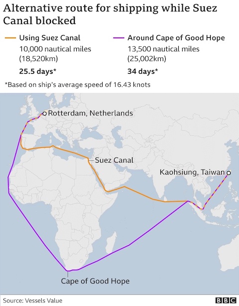
- This shortcut avoids a long and dangerous route around Africa. The Red Sea route cuts 3,500 nautical miles (6,500 km) off a typical Europe-to-Asia trip, saving anywhere from 10 to 28 days of travel.
- On March 23, 2021, on a trip from Malaysia to the Netherlands, the MV Ever Given ran aground when high winds turned it diagonally in a narrow one-way stretch of the Suez Canal during a dust storm. The 1,300-ft-long (400 m) ship is longer than the canal is wide, so it became jammed in the canal.
- A traffic jam of more than 200 vessels stacked up over six days until a spring high tide helped free the ship on March 29.
- This event highlighted the fragility of Earth’s transportation and distribution infrastructure.
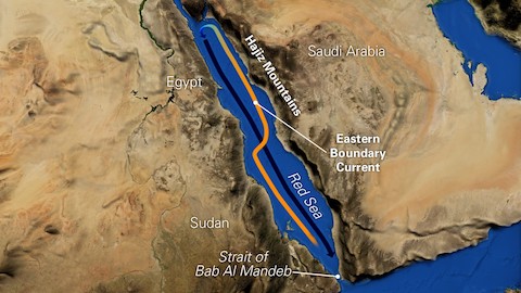
- Surrounded by desert, the Red Sea has one of the highest evaporation rates on Earth and contains some of its hottest (86°F, 30°C) and saltiest (36–41 parts per thousand) seawater.
- To replenish water lost through evaporation, surface seawater flows northward into the Red Sea from the Gulf of Aden, first hugging the western shore in the southern half of the basin, then crossing to the eastern shore in the north.
- In the winter, the surface water is blown through several mountain gaps by dry desert winds from Saudi Arabia, causing evaporative cooling and further increasing seawater salinity. The denser water plunges downward to form a cold, high-salinity bottom current that runs southward toward the Gulf of Aden.
- In the summer, African winds blow through Sudan’s Tokar Gap causing increased surface water mixing that diminishes the eastern boundary current.
Credit: Natalie Renier, WHOI Oceanus
- The practical, modern nautical shortcut through the Red Sea would not be possible without plate tectonics.
- The Red Sea is a relatively new sea. For hundreds of millions of years, the resilient Arabian-Nubian continental shield was stable in the region.
- But about 30 million years ago, late Oligocene volcanism began in two mantle-plume-related centers, one in the south near Yemen and the other in the north near Cairo, Egypt.
- Continental rifting ultimately stretched and cracked the continental shield between the two mantle plumes.
- As Arabia moved slowly away from Africa more than 20 million years ago, the Mediterranean flooded the new basin as far south as Yemen.
- As rifting continued into the late Miocene, the connection to the Mediterranean through the Gulf of Suez closed as the Sinai Peninsula rotated to form the emergent Isthmus of Suez and the first vestiges of the Gulf of Aqaba.
- This turned the Red Sea into a huge saline lake where salt deposits accumulated for about 10 million years.
- This isthmus served as an important land bridge for Pliocene fauna between Asia and Africa and today is the location of Suez Canal.
- Sometime during the Pliocene, continued tectonism caused the southern high block between Djibouti and Yemen to founder, opening the Red Sea to inundation by the Indian Ocean through the Gulf of Aden.
- Thick salt obscures imaging of the Red Sea basin floor, and researchers disagree about the onset of oceanic crust emplacement, with estimates ranging from 13.5 million years ago (Miocene) to just 1 million years ago (Pleistocene).
- The current Red Sea spreading rate is about 0.4 in (1 cm) per year, but its extension is sporadic. During a three-week period of tectonic activity in 2005, the sea’s width increased by 26 ft (8 m).
- The deepest point of the Red Sea is 9,974 ft (3,040 m) below the surface. Since 1949, hot brines and rich metalliferous muds have been reported in deeper segments of the basin, leading to interest in mining exploration.
Credit: Eric Gaba (Sting), via Wikimedia Commons
- The Red Sea provides 1,200 mi (1,931 km) of the Europe-to-Asia shortcut, but the 75-mile-wide (120 km) Isthmus of Suez blocked the connection between the Indian Ocean and the Mediterranean, so humans engineered a solution: the Suez Canal.
- As early as 2000 BCE, shallow canals were dug between the Nile River and the Gulf of Suez.
- The first suggestion of building a deep canal across the Isthmus of Suez was documented in 800 CE, made by an Abbasid caliph named Hārūn al-Rashīd.
- The idea was abandoned for centuries over concerns that the two seas had different surface elevations.
- Lacking a sea route, horse-drawn vehicles and trains were used to traverse the isthmus as trade grew between Great Britain and its Indian Ocean colonies.
- In the 1830s, French engineers determined that the levels of the Mediterranean and Red Seas were the same, and that a canal could be built without any locks. By 1858, the Suez Canal Company was formed.
- Construction started in 1859 under the authority of the Ottoman Empire and took 10 years.
- The Suez Canal Company employed more than 1.5 million people. Many of the workers were slave laborers, and many died of cholera.
- The route makes eight bends to utilize natural lakes as harbors along the way, with a final length of 120 mi (193 km).
- The cost of the canal was double the original estimate, for a total of more than $4 billion in today’s dollars.
- On November 17, 1869, the canal opened, and in 1870, 486 ship transits occurred.
- Today, the Suez Canal makes the Red Sea shortcut one of the most essential trade routes in the world. Some economists estimate that the March 2021 blockage cost the global economy around $400 million per hour.