Credit: DonZaucker, CC BY-SA 4.0, via Wikimedia Commons
More than 2,000 years ago, Rome became the first city in the world with a population of 1 million people. And one of the reasons? Abundant, clean water.
Rome’s earliest settlements go back 10,000 years. The famous “Seven Hills of Rome” were first ancient hilltop villages that gradually merged into one city.
Rome’s early citizens took their water from the Tiber River, but the growing population required more. So, Rome’s early engineers went looking for it.
And engineers were required, because Rome set out to build aqueducts. The first was just 10 miles long, tying together a series of springs. They buried its entire length for defensive reasons.
With that success, Rome built 10 more aqueducts, stretching as far as 60 miles from the city. Many were also underground. But some had to be carried on long, arched colonnades to cross low points in the landscape.
To keep the water flowing but the water pressure manageable, the aqueducts were carefully constructed with very shallow slopes, sometimes as little as a tenth of a percent.
At their peak, Roman aqueducts brought in nearly 40 million gallons of fresh water each day, supplying 900 bathhouses and 1,200 fountains.
2,000 years later, the famous Trevi Fountain is still fed by one of them.
If you have a chance to see it, you’re experiencing not just beautiful art, but an engineering marvel of the ancient world.
Background
Synopsis: Rome wasn’t built in a day, and its growth depended on fresh mountain water delivered to its amazing water distribution system by its 11 aqueducts, one of which is still flowing 2,000 years later. Ancient Roman engineers built miles of aqueducts to exacting standards with the tools they had available, enabling the city to thrive for centuries.
- Rome’s history as a continuously occupied city spans three millennia.
- Rome is located along the shores of the Tiber River in west-central Italy.
- It is often referred to as the City of Seven Hills—Sette Colli di Roma. These hills are the remnants of a volcanic plateau that was eroded by the Tiber River and its tributaries during the middle to late Pleistocene Epoch (774,000–11,700 years ago).
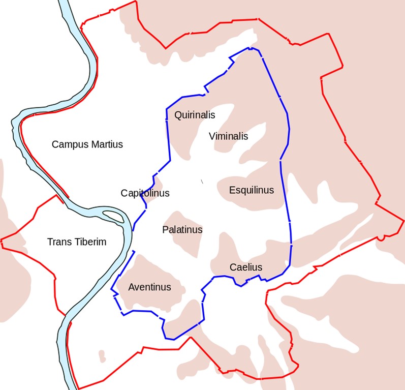
A schematic map of ancient Rome, showing the fourth-century-BC Servian Wall (and its 16 major gates) with a blue line and the third-century-AD Aurelian Wall with a red line. Highlands are colored, including the Seven Hills of Rome (with their names).
Credit: Richardprins, CC0, via Wikimedia Commons - Archaeological evidence of human occupation of Rome extends back more than 10,000 years, with individual settlements developing atop each of the seven hills.
- The settlements merged as the intervening marshes were drained and reclaimed for agriculture that raised the region above subsistence level, supporting its growth as a population center.
- Roman mythology dates the founding of the city to 753 BC with the legend of the twins Romulus and Remus. The city was named after Romulus.
- In the early fourth century BC, the Servian Wall was constructed to protect the seven hills. Researchers have found grout in the wall dated to 378 BC.
- Early Romans used water from the Tiber River as well as rainwater catchment, local wells and springs, but by the late fourth century BC¬¬ these water sources were inadequate for the growing population, and some had become polluted.
- The city needed a secure, clean water supply.
- Assyrians built the first aqueducts around 700 BC for their gardens at Nineveh (now in northern Iraq).
- In 312 BC, Appius Claudius Caecus began construction on his famous long road from Rome to Italy’s “bootheel”—the Appian Way. He completed Rome’s first aqueduct, the Aqua Appia, the same year.
- The aqueduct’s water source was a series of springs with a water level 78 ft (24 m) above sea level that was 10 mi (16.2 km) east of its destination in Rome.
- Over that distance the height of the water dropped just 30 ft (9 m), or 0.055%—just a 35-inch drop per mile (50 cm per km)—to 49 ft (15 m) above sea level.
- The Aqua Appia was constructed entirely underground outside of the Servian Wall for defensive reasons.
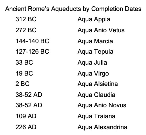
- Eleven aqueducts, some as long as 57 mi (92 km), were constructed to supply ancient Rome between 312 BC and AD 226, and each was built to exacting standards.
- Each aqueduct had to start from a water source higher than its destination, usually a spring, river or lake in the surrounding limestone mountains.
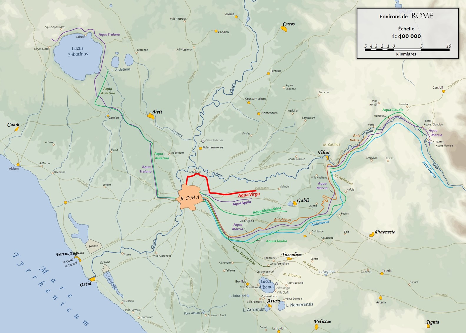
Map showing the routes of the aqueducts of Rome, some of which were 57 miles (92 km) long. The oldest aqueduct, built in 312 BC, is the Aqua Appia (purple). The Aqua Virgo (red) was built in AD 19 and is still flowing to Rome’s famous Trevi Fountain 2,000 years later. Aqueduct routes are from an 1886 base map in G. Droysen’s General Historical Hand Atlas (1886).
Credit: Cassius Ahenobarbus, via Wikimedia Commons - Aqueducts operate by gravity flow, so the water level required to maintain flow dictates the elevation of the structure built to contain the flowing water.
- The course of the aqueduct must constantly slope downward to keep the water moving toward the destination without stagnation, but it must be at a pace that constrains the water pressure at the end of the line to a rate that is manageable.
- Most aqueducts have overall slopes ranging from just 0.3% to 0.013%, an amazing engineering feat given the tools available at the time.
- Slopes were calculated using ancient devices including the groma, chorobates and dioptra.
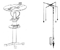
Left: Dioptras were used for precise measurement of angles.
Left Credit: H. Schöne. - Leipzig: B. G. Teubner, 1903Klingsor at German Wikipedia, public domain, via Wikimedia Commons
Right: The groma was used to survey straight lines and right angles.
Right Credit: flamenc, Hartmann Linge, via Wikimedia Commons - For most of their distance these ancient aqueducts ran through underground tunnels for practical, defensive and engineering reasons. Tunnels don’t disturb surface activities, are secure from contamination and tampering, and enable siphons to work. Some tunnels were just 5 ft (1.5 m) deep, while others ran through hills on the way to their destination.
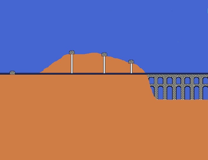
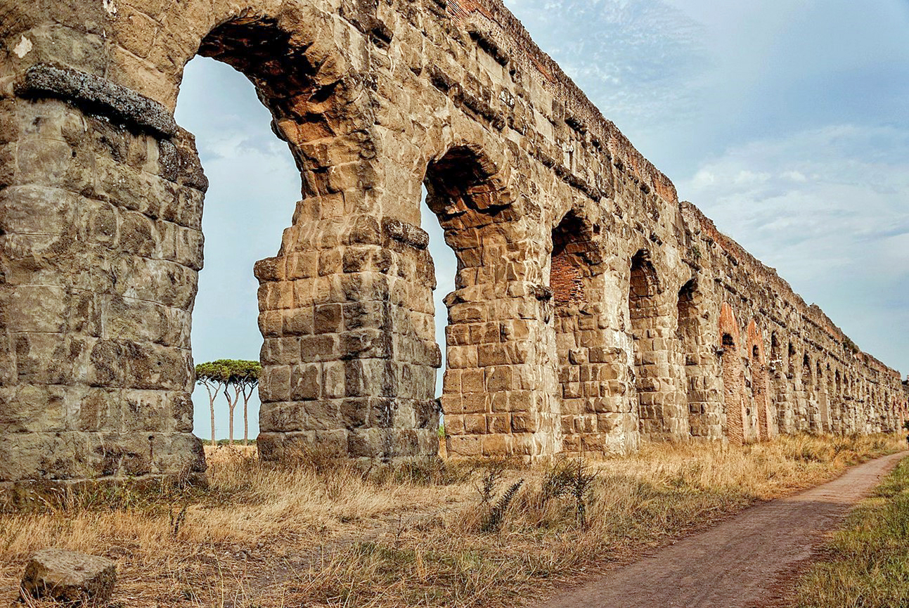
Aqueducts were built with tunnels and arched bridges called “arcades” to maintain their slope toward their destination. In regular intervals in tunnels, inspection and maintenance shafts were constructed.
Credit: Longbow4u, public domain, via Wikimedia Commons - When tunnels couldn’t be built, bridges with arches called “arcades” were built to support the aqueduct, which was almost always covered from the elements. Arches decreased surface impact from flooding when compared to solid walls, and their graceful curves accentuated the beauty of the countryside.
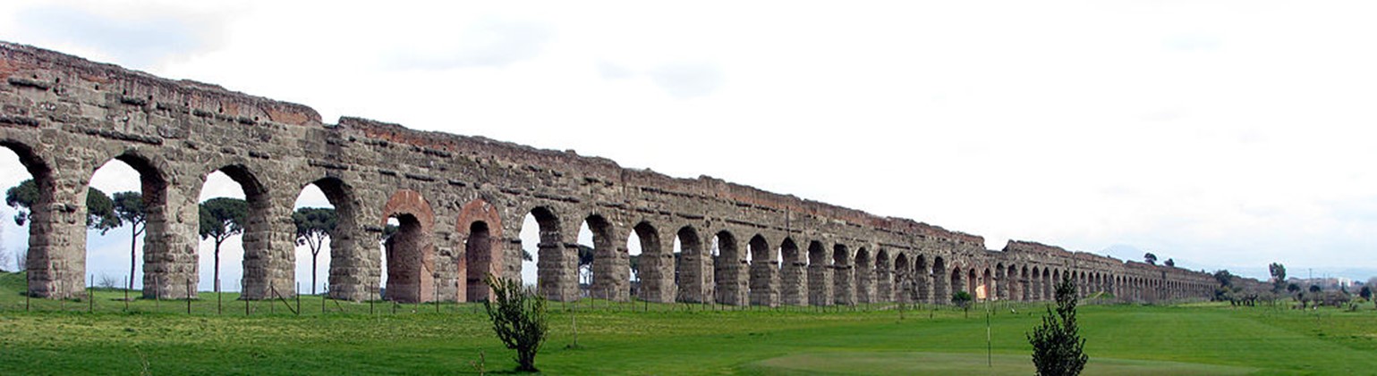
Panoramic view of the Aqua Claudia near Rome, the longest unbroken stretch of an aboveground aqueduct arcade, near Via Lemonia, Rome, with a length of 0.85 mi (1,375 m). On top of the Aqua Claudia is the Aqua Anio Novus.
Credit: Chris 73, via Wikimedia Commons - Sometimes, in rugged topography, enclosed aqueducts would dip downward and back upward as a siphon. As long as the water flow was uninterrupted, the siphon would continue flowing toward the destination.
- To prevent leaking, aqueducts had to be lined with concrete, and the Romans used a volcanic ash–based material called pozzolana that could set underwater.
- The mineral-rich water would encrust the aqueducts and occasionally had to be chipped out by enslaved people.
- Each aqueduct had to start from a water source higher than its destination, usually a spring, river or lake in the surrounding limestone mountains.
- The aqueducts were part of an elaborate water distribution system for drinking water, fountains and baths in the city.
- When the water reached Rome, it would enter settling basins that were like pools, enabling suspended sediment to drop out.
- The water would flow through the city’s water distribution system, most of which was constructed of lead pipes.
- At its peak, Rome had more than 1,200 fountains and nearly 900 baths that were supported by more than 38 million gallons of water per day delivered by the 11 aqueducts.
- In dry times the water distribution would be prioritized among street basins, fountains, baths, and private residences.
- The Aqua Virgo still flows more than 2,000 years after it was built in AD 19.
- It has an astonishing gradient of just 0.013%—less than 9 inches per mile (13 cm per km).
- It has been reconstructed several times through history.
- Its water is no longer potable because of infiltration of pollution into its buried course, but it still supplies the famous Trevi Fountain that was completed in AD 1762.

Rome’s Trevi Fountain measures 86 ft (26.3 m) from front to back and 161 ft (49 m) from side to side. The fountain was constructed from AD 1735 to 1762.
Credit: NikonZ7II, CC BY-SA 4.0, via Wikimedia Commons
- With its reliable water supply, Rome’s population and culture thrived.
- It grew to become the first city in the world with a population that reached 1 million people. This is believed to have occurred sometime around 133 BC.
- Abundant water was also key to the cultural vibrance of the city, which was known for its cleanliness.
- During the eighth century AD, Rome became the capital of the Papal States.
- It was one of the major centers of the Renaissance and the birthplace of the baroque style and neoclassicism.
- In AD 1871 Rome became the capital of the Kingdom of Italy, which became the Italian Republic in 1946.
- It is the only city in the world with a country—the Vatican—within its city limits.
- Today, Rome is the capital of Italy, with a population of more than 4 million people.
- The Romans built over 200 aqueducts in Italy, France, Spain, Turkey, North Africa and the Middle East. Stunning aqueduct arcades became the signature of the Roman Empire around the region.
- Designed in the same way as the ancient gravity-flow aquifers, California’s aqueduct system is the longest in the world, conveying around 650 million gallons of water (2.5 billion liters) each day from the wet northern regions of the state for more than 440 mi (700 km) to its drier southern areas.
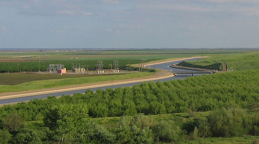
The California Aqueduct as it passes through orchards near Interstate 5 in the western San Joaquin Valley, Central California.
Credit: Triddle at English Wikipedia, public domain, via Wikimedia Commons
- Designed in the same way as the ancient gravity-flow aquifers, California’s aqueduct system is the longest in the world, conveying around 650 million gallons of water (2.5 billion liters) each day from the wet northern regions of the state for more than 440 mi (700 km) to its drier southern areas.