Credit: Meg Stewart, CC BY-SA 2.0, via Wikimedia Commons
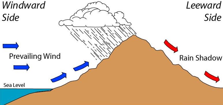
Mountains can shape not only a region’s weather, but its climate.
When wind blows warm moist air against a mountain range, the air is pushed upward by the mountain. As it rises, it cools.
The moisture within it condenses into rain, which falls on the front side of the range, creating a lush landscape.
But behind the range, the air—now empty of moisture—can leave the landscape extremely dry. The mountains have essentially blocked the passage of weather systems. This is called a rain shadow.
These very dry areas occur frequently when oceans, or even very large lakes, meet coastal mountain ranges. The air charges with moisture over the body of water, dumps it on the coast and leaves the interior dry.
We see rain shadows in California, where the Sierra Nevada catches the moisture from the Pacific and produces Death Valley to the east.
And in China, on the Tibetan Plateau, where the Gobi Desert stretches out behind the Himalayas. And in South America, where the Atacama Desert has formed behind the Andes—it’s one of Earth’s driest environments.
Even the Great Plains of the U.S., once called the Great American Desert, are kept sometimes dangerously dry by the Rocky Mountains, which form a barrier across the country.
Rain shadows are a permanent climatic feature on the landscape—or at least, as permanent as the mountains and winds that create them.
Background
Synopsis: In mountainous regions, topography can influence not just weather, but climate. When winds are driven uphill, their moisture condenses, raining down on the lush windward side of the prominence. This depletes the moisture in the air, turning the leeward side into a desert known as a rain shadow. Some of Earth’s largest topographical features are associated with permanent rain shadows, including the Gobi Desert on the leeward side of the Himalayas.
- Orographic lift occurs when prevailing winds encounter highlands and are driven upslope. The drop in pressure results in adiabatic cooling of the air as it expands.
- This cooling of the air causes its moisture to condense and fall as rain as it sweeps uphill on the windward side of the range, depleting the air of moisture.
- As the air passes over the range, it warms through adiabatic compression as pressure increases downslope and dries as its capacity for moisture increases.
- As it moves downslope, the now dry air desiccates the downwind leeward terrain, producing a rain shadow where precipitation seldom occurs.
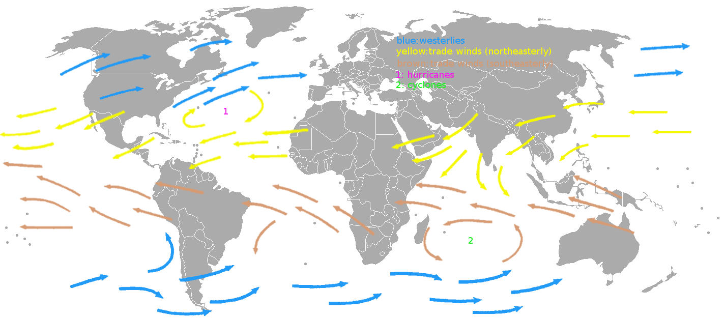
Prevailing winds occur in specific geographical bands and consistently blow from a single direction in those regions. At low latitudes the trade winds are predominantly easterly, while in the mid-latitudes westerlies dominate, although these patterns are less organized over land. Wind shadows form in areas behind topographic features that block these consistent winds.
Credit: KVDP, public domain, via Wikimedia Commons - The mountains essentially block the passage of weather systems.
- Rain shadows typically develop where moist onshore breezes from oceans or large lakes encounter terrain.
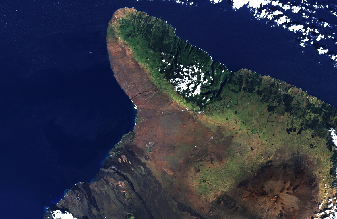
Satellite image of the Kohala Mountain Range on the northern coast of Hawai‘i's Big Island. The mountains block most precipitation from the northeasterly prevailiing winds from reaching the valley to the southwest, creating a dry climate where few plants grow.
Credit: Landsat 7 image, USGS - Similar to a regular shadow that intercepts light to make a dark area, a rain shadow is formed when moisture is intercepted, resulting in a dry zone.
- Rain shadows are persistent climatic features known for their water-limited resources.
- Wherever there are large mountain ranges, there are related rain shadows.
- Earth’s largest rain shadow occurs north of the Himalayas in the Gobi Desert and the Tibetan Plateau as northward-directed weather systems are stalled on the southern flanks of the Himalayas.
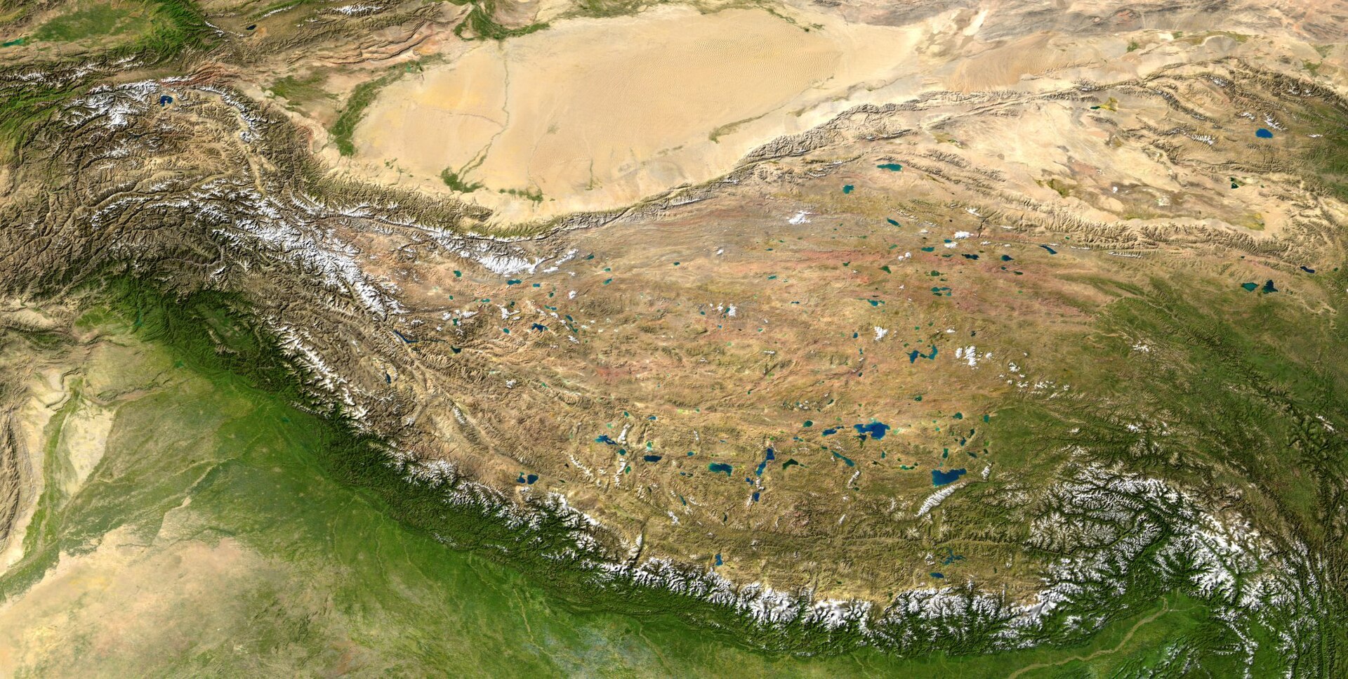
The Tibetan Plateau (center) may be the best example of a rain shadow on Earth. Rainfall from the southern South Asian monsoon does not make it past the Himalayas (seen by the snow line at the bottom), leading to an arid climate on the leeward (northern) side of the mountain range and the desertification of the Tarim Basin (top).
Credit: NASA - The Andes of South America show the effect of two different prevailing wind directions on its rain shadow regions. The range is more than 4,400 mi (7,000 km) long and more than 300 mi (500 km) wide in places.
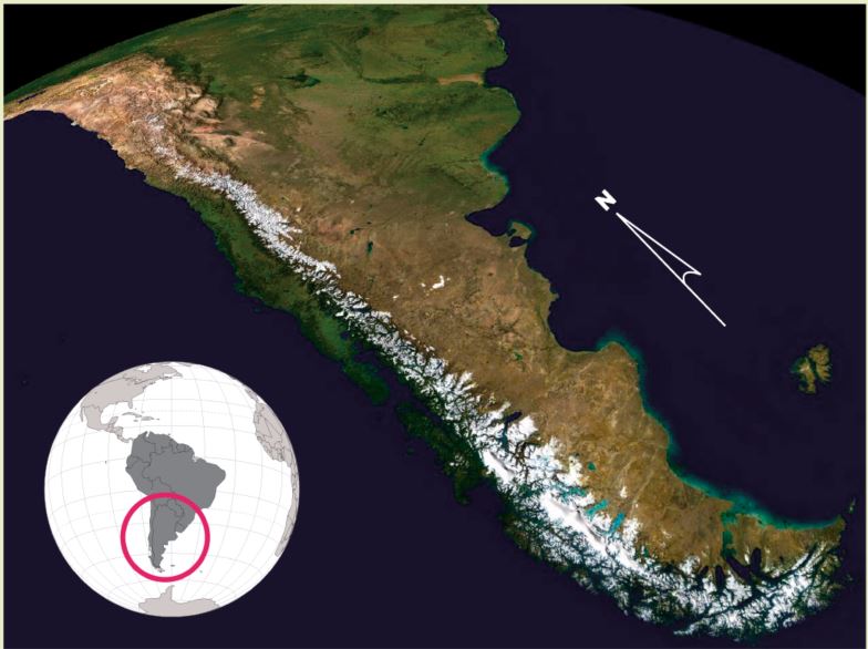
A view of the Andes from the southwest (using NASA’s WorldWind globe software) shows two different rain shadow effects. One to the east of the Andes in the south (in Chile and Argentina), where westerly Pacific winds predominate. Note the tan desert east of the Andes. The other rain shadow lies to the west of the Andes in the north (in Bolivia and Peru), where the southeasterly Atlantic trade winds are blocked by the eastern side of the range, forming one of Earth’s driest places, the Atacama Desert (the tan desert west of the Andes).
Credit: NASA WorldWind, public domain, via Wikimedia Commons - On a grand scale, all of the North American Interior Plains are shielded from the prevailing westerlies carrying moist Pacific weather by the North American Cordillera, but particular valleys within the Cordillera exhibit strongly pronounced effects. Death Valley is a rain shadow of the Sierra Nevada Range.
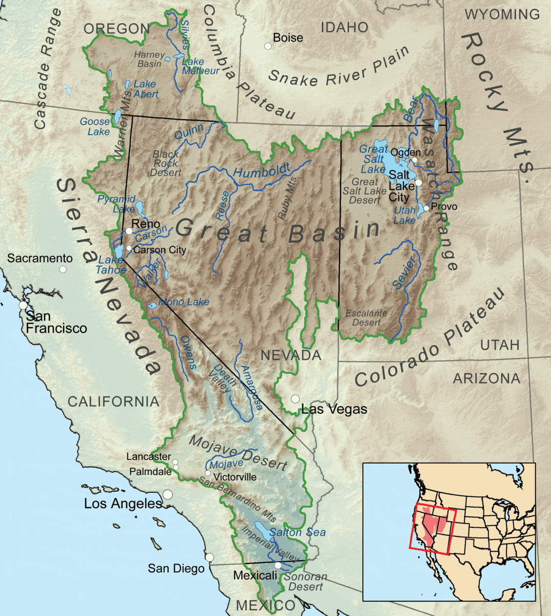
The Cascade Range to the north and the California Coast Ranges and the Sierra Nevada to the south provide a significant rain shadow effect for the inland North American deserts.
Credit: Kmusser, CC BY-SA 3.0, via Wikimedia Commons - While many rain shadows occur onshore of ocean coastlines, some also exist onshore of inland bodies of water such as the Caspian Sea.
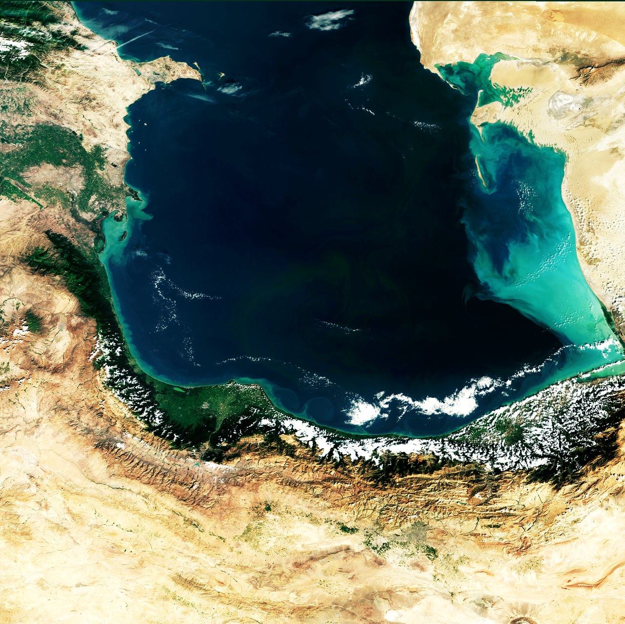
A view of the southern end of the Caspian Sea, with Iran to its south, Azerbaijan to its west and Turkmenistan to its east. Most of Iran is rain shadowed by the Alborz Mountains just south of the Caspian Sea, causing the country's mostly (semi) arid climate.
Credit: ESA, CC BY-SA 3.0, via IGO
- Earth’s largest rain shadow occurs north of the Himalayas in the Gobi Desert and the Tibetan Plateau as northward-directed weather systems are stalled on the southern flanks of the Himalayas.