Credit: PsamatheM, via Wikimedia Commons
A thousand years before the Inca, in the deserts of Peru where rainfall is almost nonexistent, lived a civilization so advanced they’d figured out how to use wind to pump water.
The Nazca people were fantastic artists, famous among anthropologists and ancient art collectors for their textiles and ceramics. But they were also brilliant engineers.
Over generations, they constructed a sophisticated water system.
They trenched and tunneled into the gravelly water table of the Andean foothills, then built underground aqueducts, lined with smooth river stone, to move the water down to them.
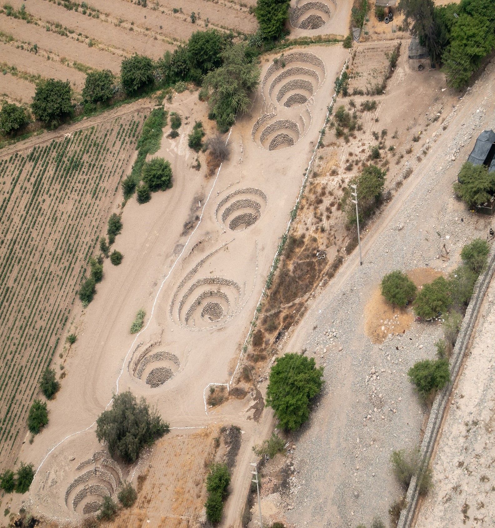
Miles of these tunnels supplied their towns and irrigated their fields in the coastal desert. Along them, they constructed broad spiraling holes called ojos, or eyes, some of them 50 feet in width.
These served as access portals for the Nazca to descend into, clean and maintain the aqueducts.
Recently, a team of scientists discovered that the ojos’ spiral mouths, and their positioning, had a further purpose. They caught the prevailing winds and ducted them down into the system, using the increased air pressure to pump the water along.
It’s a system so well engineered and constructed that 36 of these aqueducts are still in service today, 1,500 years later, bringing water to a city that bears the name of these ancient architects: Nazca, Peru.
Background
Synopsis: When we hear “Nazca,” most of us think about the Nazca Lines etched into the desert plains of southern coastal Peru, but, around 1,500 years ago, these ancient engineers also developed subterranean aqueducts that incorporated what may be the world’s first hydraulic pumping system. Spiral ojos are thought to have entrained prevailing winds to pump water underground from the Andean foothills toward Nazca villages and fields.
- The Nazca culture flourished in what is now southern Peru from around 200 BC to about AD 600 (the Incan civilization prospered in the region from around AD 1100–1572).
- This civilization is most renowned for the mysterious Nazca Lines constructed over many generations on the wide desert plains of the Nazca Valley.
- They were constructed by gouging 4–6 in (10–15 cm) deep grooves in the dark pebbled desert surface to expose underlying lighter material.
- Used for religious ceremonies, they have persisted for many centuries in the arid climate.
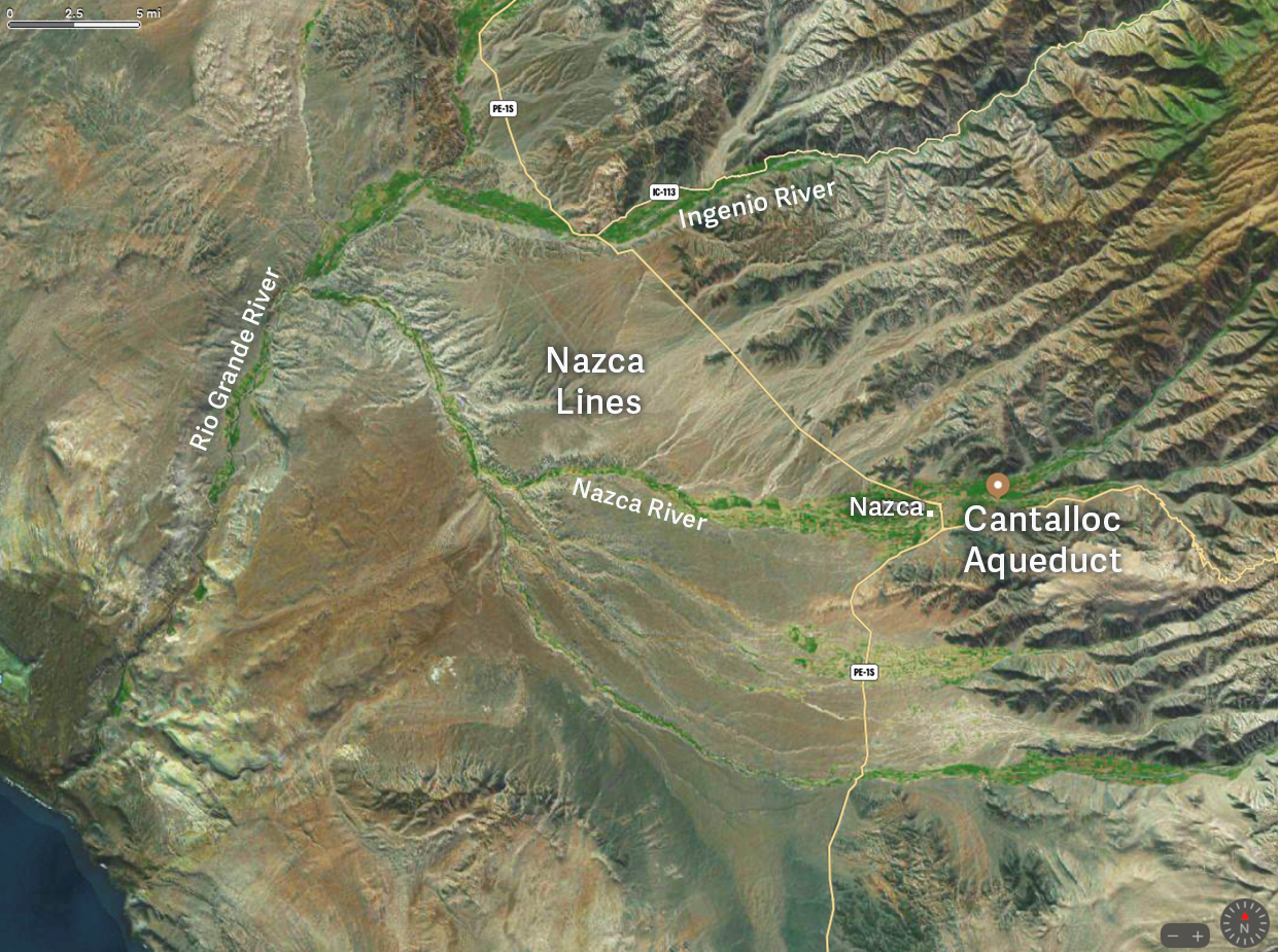
The Nazca Lines can be seen between the northern Ingenio River and the central Nazca River. Some of the best preserved puquios occur at the Cantalloc Aqueduct (marked by the brown dot) in the town of Nazca, Peru. The Pacific Ocean can be seen at the lower left.
Credit: Google Maps - The Nazca culture is also known for its pottery and textiles.
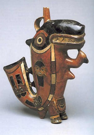
Killer Whale slip glazed pottery from the Nazca culture, 200 BC–AD 600, at the Larco Museum in Lima, Peru.
Credit: Lyndsayruell, via Wikimedia Commons
Detail of textile border figures, Nasca, Mantle ("The Paracas Textile"), 100–300 CE, made of cotton and camelid fiber, found at the south coast of Paracas, Peru, in the Brooklyn Museum.
Credit: Unknown photographer, public domain, via Wikimedia Commons
- While Nazca artists created awe-inspiring crafts, around AD 450, Nazca engineers were busy working out how to supply this collection of chiefdoms with water in the exceedingly arid region, where annual rainfall is so scarce it cannot be measured.
- Researchers estimate that a fairly dense population of up to 25,000 Nazca people lived in a collection of small villages built on terraced hillsides alongside irrigated fields of crops like cotton, beans and potatoes on nearby floodplains.
- Lacking rainfall, irrigation was accomplished by tapping into buried aquifers draining the Andean foothills within the gravelly alluvial fans that fill the valleys.
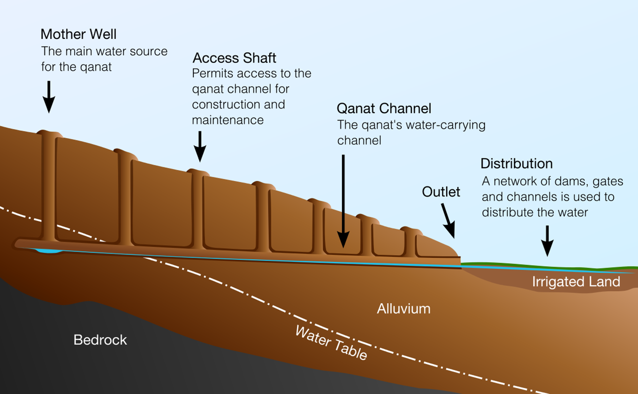
A cross section of a typical qanat from ancient Persia, some of which are believed to be 3,000 years old.
Credit: Samuel Bailey, via Wikimedia Commons - Similar to qanats constructed in ancient Persia (modern Iran), Peru’s puquios include nearly horizontal subterranean aqueducts that tap into uphill aquifers, sloping gradually coastward toward settlements and fields and ending in open canals and reservoirs (cochas) used for irrigation.
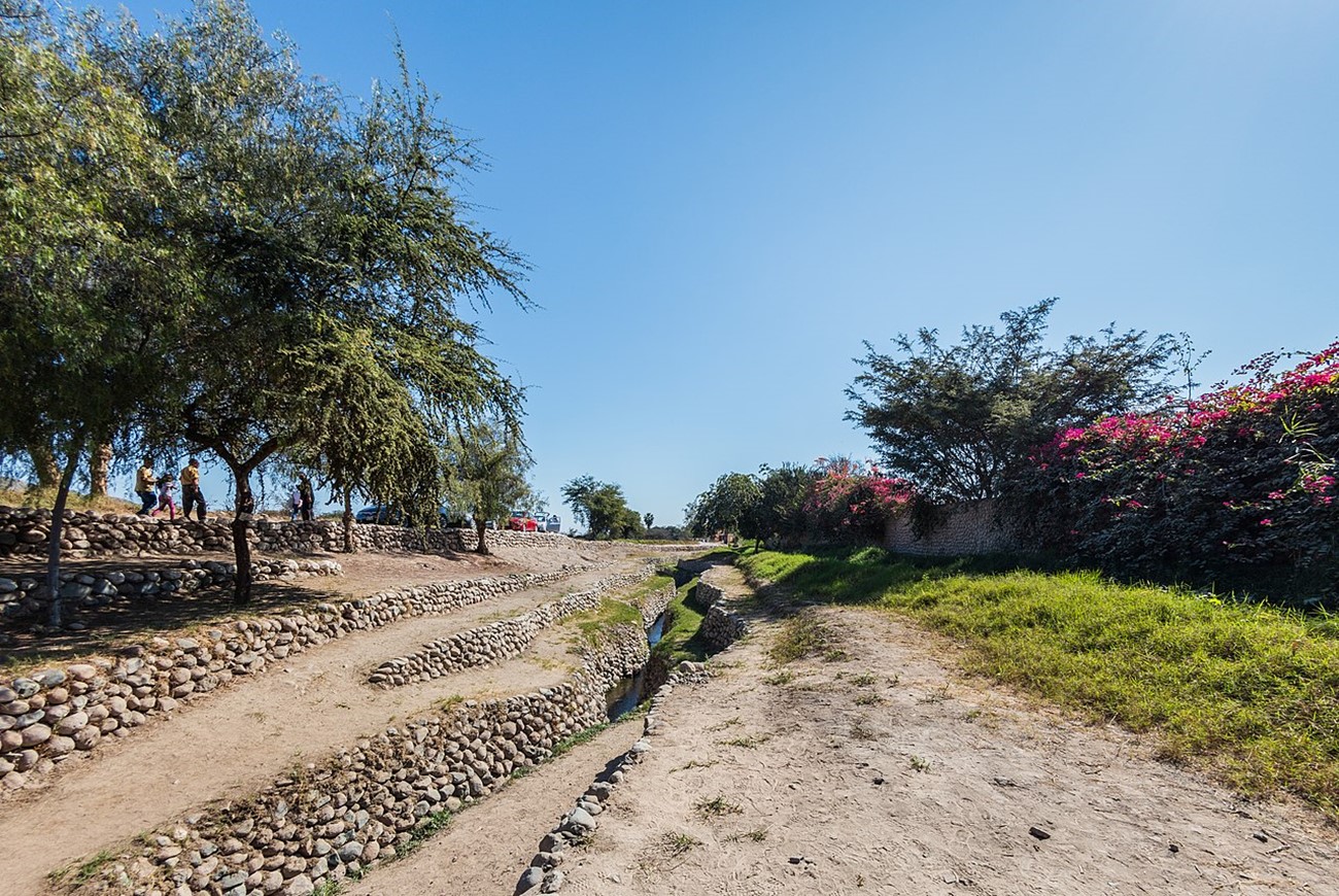
Open aqueducts and reservoirs are part of the Puquio system near Nazca, Peru.
Credit: Diego Delso, via Wikimedia Commons
- The open canals, subterranean aqueducts and access shafts of the puquio systems are rock lined and constructed without the use of mortar to enable better water percolation.
- Open canals are about 3 ft (1 m) wide at the base, opening out to around 30 ft (10 m) at the top.
- Tunnels are as much as 33 ft (10 m) wide and are accessed by corkscrew-shaped openings up to 50 ft (15 m) wide known as ojos (eyes).
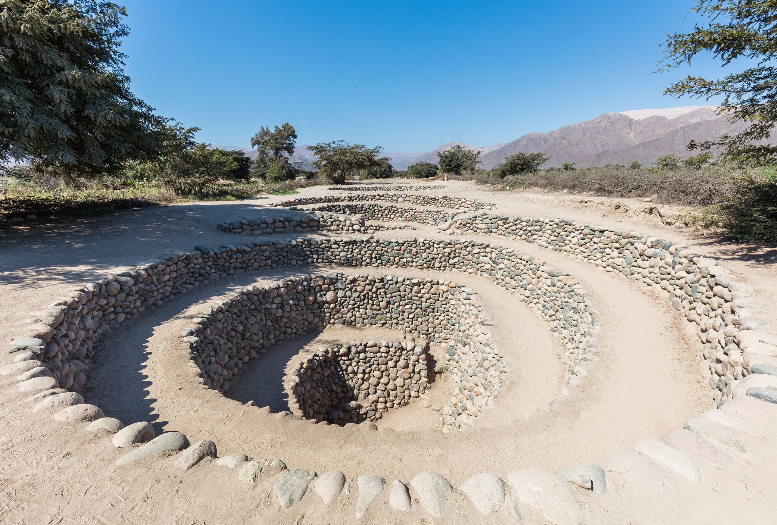
View of a few of rock-lined ojos along the Cantalloc puquios above a subterranean aqueduct near the city of Nazca, Peru.
Credit: Diego Delso, via Wikimedia Commons - Originally, the intricately designed ojos were just thought to provide access for maintenance, but scientists have discovered a different reason for the spirals.
- Prevailing winds blow downward into the spirals pushing water through the aqueduct toward the reservoirs.
- This vast hydraulic system may have been the first wind-driven pump for moving water at this scale on Earth, making water accessible year-round to these desert dwellers.
- Researchers have used multispectral satellite imagery to map the extent of excess moisture in the soil to demonstrate a network of puquios leading to Nazca settlements.
- Archaeological evidence shows that the area would not have been habitable during the Nazca period without access to water via the puquios.
- Today, 36 puquios are still in use, delivering water to residents of Nazca for more than 1,500 years.
- Ultimately, the Nazca civilization withered at the end of a 30-year drought around AD 500 and fell to the Wari people, who took over their settlements, artistic techniques and technological developments.