North America’s Great Lakes are great indeed.
They contain 20 percent of the planet’s surface freshwater—enough to cover the continental U.S. 10 feet deep.
They formed at the end of the last Ice Age, when Canada was under an ice sheet 3,000 to 9,000 feet thick.
This massively heavy continental glacier had flowed southward, depressing and carving the Earth as it passed over, pushing ahead of it huge piles of eroded rock and gravel called glacial moraines.
20,000 years ago, the ice sheet finally began to melt. As the glacier receded northward, floods of meltwater filled the deep depressions it had carved and were trapped in place by the banks of moraines it left behind.
Over centuries, this formed the Great Lakes.
But the areas the glacier eroded, and therefore the shape of the lakes, were determined by geology long before that.
Lake Superior began life a billion years ago as a huge rift, a crack in the continental crust. Over millions of years it filled with sediment, which was soft and easy for the glacier to eventually scour away.
Lakes Michigan and Huron were likewise carved out of softer sedimentary rock that surrounds the harder rock that makes up the state of Michigan.
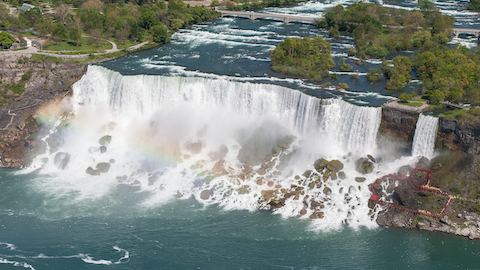
Lakes Erie and Ontario are the shallowest and smallest, both carved into weaker shales and connected by Niagara Falls, which flows over a harder dolomite shelf.
The Great Lakes are truly one of America’s great places, in natural beauty and history.
Background
Synopsis: The Great Lakes contain 20% of Earth’s liquid surface freshwater—enough water to cover the contiguous United States in about 10 ft (3 m) of water. The lakes formed by glacial erosion, but geological features that formed 300 million to 1.2 billion years ago predetermined the shapes of America’s huge inland seas.
- The Great Lakes contain more than 6 quadrillion gallons (23 quadrillion liters) of freshwater—20% of Earth’s liquid surface freshwater.
- Only 1% of Earth’s water is liquid freshwater, and only 1% of that is on Earth’s surface. One-fifth of that is in the Great Lakes, representing 85% of the liquid surface freshwater in North America.
- 1.5% of Earth’s water is frozen freshwater in glaciers.
- 97.5% of Earth’s water is salty, either in the oceans or as salty groundwater.
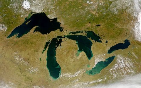
- Four of the five Great Lakes form the border between the United States and Canada. Lake Michigan is entirely within the United States.
- From west to east, the lakes are named Superior, Michigan, Huron, Erie, and Ontario.
- U.S. states Minnesota, Wisconsin, Michigan, Ohio, Pennsylvania, and New York have shorelines along the south side of the lakes, across from Ontario to the north in Canada.
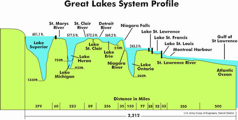
- The lakes all have similar water surface levels except Lake Ontario, which drops down across Niagara Falls.
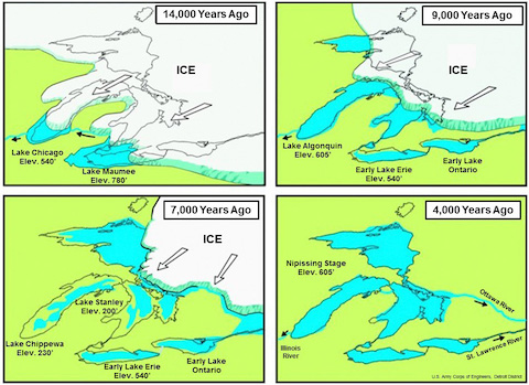
- The lakes formed at the terminus of the Laurentide Ice Sheet during the final phase of Pleistocene Epoch glaciation, but they inherited their shapes from preexisting geology in the region.
- The ice sheet started forming about 2.6 million years ago, after which it retreated and advanced multiple times in various waves. The last wave of Pleistocene glaciation pushed to its maximum extent between 25,000 and 21,000 years ago, plowing terminal moraines southward ahead of the glacial lobes. The Laurentide Ice Sheet is estimated to have been up to 3,000 ft (1,000 m) thick in the area of the lakes and possibly more than 9,000 ft (3,000 m) thick farther north.
- The leading-edge glacial lobes followed the easiest paths, which traced along preexisting drainages that had formed in weaker rocks exposed at the surface.
- As the Laurentide Ice Sheet began its retreat about 20,000 years ago, glacial floods cut deeply into the exposed geology, and terminal moraines dammed the meltwater to form lakes.
- At times, flooding caused all the lakes to merge into single larger lakes, such as Lake Algonquin, but as lake levels stabilized, the five modern lakes took shape.
- Lake Superior is the largest, deepest, coldest, and clearest of the lakes, containing as much water as the other four lakes combined.
- Retention time for a drop of water in Lake Superior is nearly 200 years.
- The geology surrounding Lake Superior is Precambrian in age, with rocks as old as 3.6 billion years exposed in cratons—old, stable blocks of the Earth’s crust—on the Upper Peninsula of Michigan.
- The shape of Lake Superior follows the track of the 1.1-billion-year-old Midcontinental Rift System, which began to break apart the North American craton right through the middle but failed. The rift filled with more than 5 mi (8 km) of sediments as a large basin subsided along the rift zone.
- These sediments were easy for streams to erode; the erosion produced a large valley that glacial lobes accessed a billion years later, gouging an even deeper trough that filled to become today’s Lake Superior.
- Lakes Michigan and Huron are connected by the Mackinac Straits; some people consider them to be a single lake.
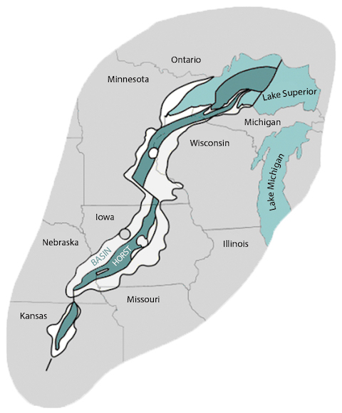
- The lakes encircle the state of Michigan for a good reason.
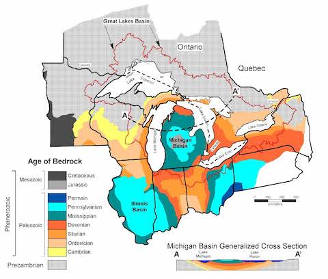
- Michigan—with the exception of half of the Upper Peninsula—lies within the Michigan Basin, a circular basin that extends from far eastern Wisconsin to the eastern edge of Lake Huron, and from halfway through the Upper Peninsula south to northern Indiana and Ohio.
- From 500 million to 300 million years ago, sediments more than 14,000 ft (4,267 m) thick accumulated in the basin as ancient inland seas grew (transgression) and shrank (regression) close to 30 times, depositing the sediment with each transgression and regression.
- The result looked like a stack of nested bowls, with the oldest and weakest sedimentary rocks on the bottom and far edges of the basin.
- When Pleistocene glaciation began, glaciers preferentially scoured softer, early Paleozoic sedimentary rocks, avoiding the stronger, younger sedimentary rocks that still protectively cover the lower part of the state today.
- As the glaciers scoured out the soft rock, they left behind chasms, which filled with water and became Lakes Michigan and Huron.
- Water in Lake Michigan, the third largest of the lakes, moves very slowly in a counterclockwise direction and is retained for 99 years on average. Water moves more rapidly through Lake Huron, with a retention time averaging just 22 years.
- Lake Huron is the second largest of the lakes and has the longest shoreline.
- The glaciated topography is so rugged that Lake Huron has more than 30,000 islands. Ontario’s Manitoulin Island is the largest island within a freshwater lake on Earth and has 108 lakes itself, some of which have small islands—so you can stand on a small island in a small lake on a large island in the large Lake Huron.
- The lakes encircle the state of Michigan for a good reason.
- Lake Erie is the shallowest and warmest of the lakes, with a water retention time of less than 3 years. Its water plunges over world-famous Niagara Falls into the deeper Lake Ontario, where water stays for about 6 years. Lake Ontario is the smallest of the five lakes.
- Erie and Ontario occur in weaker shaly beds that were more easily scoured by glacial erosion.
- A more resistant Silurian-aged dolomite between these two easily eroded shales forms the overhang of the 167 ft (51 m) cataract at Niagara Falls.
- The outflow from Lake Ontario feeds the St. Lawrence River and the Gulf of St. Lawrence before eventually making its way into the Atlantic Ocean.