Credit: Michele Pizza, CC BY-SA 4.0, via Wikimedia Commons
“Campi Flegrei” in Italian means “fiery fields.” That may not sound like a place you’d want to live, but 360,000 Italians do.
Italy is the only country in Europe with active volcanoes on land. The “fiery fields,” just west of Naples, are actually a caldera—the depression left when a volcano erupts and collapses.
At the center of the caldera is the Pozzuoli Bay. The coast around it has been densely populated for many centuries.
The volcano has had two major eruptions in the distant past, much larger than well-known Vesuvius, and smaller ones more recently. Every day, residents get geologic signals that they might be tempting fate:
Gas bubbles up in the waters of the bay. The land rapidly rises and sinks in response to shifting magma beneath—in the last 50 years, some areas have risen more than 10 feet.
Roads and buildings that once disappeared under water sometimes emerge again, including Roman ruins. And there are frequent small earthquakes.
These and other signs of volcanism are monitored closely by the Italian government. If it looked like the fiery fields were about to get fiery again, half a million people would quickly evacuate, following a well-established plan.
Why do they stay? Because it’s home, and has been for generations. Because of the sea, the sun and some of the best food in Italy—in a setting that would get any geologist fired up!
Background
Synopsis: Italy’s third-largest city, Naples, is known for its pizza, its Greek and Roman history and its close proximity to active volcanoes at Mount Vesuvius and Campi Flegrei. More than 3.6 million Italians in the Naples metropolitan area coexist with volcanism, especially those who live within the Campi Flegrei caldera, where ground surfaces have risen more than 10 ft (3 m) since the 1960s.
- On Italy’s west coast, history-rich Naples is the regional capital of Campania and the third-largest city in Italy, with a population of 3.6 million in its metro area that covers about 400 mi2 (1,000 km2).
- Naples was inhabited during the Neolithic period, then was founded as the Greek settlement of Neapolis around the sixth century BC. It fell to the Romans during the third century BC. The Romans proudly regarded it as a key cultural center.
- The area has an abundance of remarkable archaeological sites, from Greek and Roman ruins, to medieval and neoclassical castles, to baroque churches and subterranean aqueducts and catacombs.
- Naples is the birthplace of Neapolitan pizza and cuisine. Restaurants in Campania have earned more Michelin stars than any other Italian province.
- The region has a rich geologic history as well. Located along the convergence zone between tectonic plates that collided during the Alpine orogeny, Italy is the only country in Europe that has active volcanoes on the mainland.
- A plate boundary prone to earthquakes runs through western Italy—the region continues to move northward.
- Smaller microplates to the east jostle for space in this dynamic system, which has contributed to the development of several volcanic centers at various times.
Volcanic regions of Italy are related to plate boundaries that collided during the Alpine orogeny. The yellow Campanian volcanic arc includes mainland volcanoes Mount Vesuvius and the larger Campi Flegrei caldera cluster, an island volcano called Ischia, and four submarine volcanoes called Palinuro, Vavilov, Marsili and Magnaghi.
Credit: Antonov, CC BY-SA 4.0, via Wikimedia Commons
- Southeast of Naples, the ancient towns of Pompeii and Herculaneum confirm the destructive capability of Mount Vesuvius.
- The stratovolcano Vesuvius began forming its caldera around 17,000 years ago.
- Eight eruptions have occurred since then, including the devastating pyroclastic flows of the August 24, AD 79, eruption, with an ejecta volume of 1 mi3 (4.4 km3) and a volcanic explosivity index of 5 (VEI-5), that destroyed Pompeii and Herculaneum, entombing many citizens.
- Frequent smaller eruptions also occurred from 1631 through 1944, but iconic Vesuvius has been fairly quiet since then.
- To the west of Naples, Campi Flegrei doesn’t look like what most of us imagine a volcano should look like because its caldera is near sea level, creating a gentle depression inside of which more than 360,000 people live.
- A caldera is a bowl-shaped depression that forms when a volcano erupts and collapses.
- “Campi Flegrei” is an Italian name that can be translated as “fiery fields” and sometimes known as “Phlegraean Fields” in English. These fields are mentioned in mythological stories about Hercules.
Left: Tectonic setting of the Campanian Volcanic Zone, including the city of Naples (Napoli).
Right: Digital terrain model of the Campi Flegrei caldera (within the black square in the figure to the left) showing its ring faults and central resurgent dome.
Credit: M. Saachi et al., 2019, ICDP–IODP Scientific Drilling, CC BY 4.0
- Campi Flegrei has produced two of Europe’s largest eruptions in the past 200,000 years.
- Volcanic activity in the area may have started as early as 300,000 years ago.
- The first large eruption began 39,800 years ago, with a volume of at least 24 mi3 (100 km3).
- Like the AD 79 eruption of Vesuvius, this eruption produced pyroclastic flows that fused to form a rock unit known as the Campanian Ignimbrite, but its volume was about 24 times larger, making it a VEI-7 eruption.
- Traces of ash from this event have been found in Greenland ice cores, while two thick submarine deposits in the Marsili Basin south of Naples are attributed to these eruptions.
- Discontinuities in Mediterranean archaeological sequences around this Middle to Upper Paleolithic time frame along with the observed transition from Neanderthal to modern human populations suggest this Late Pleistocene eruption may have contributed to changing the course of civilization in the region.
- The second large eruption occurred about 14,900 years ago, with a volume of about 9.6 mi3 (40 km3) (VEI-6), nearly ten times as powerful as Vesuvius.
- This eruption produced the Neapolitan Yellow Tuff, a yellow-colored rock composed of volcanic ash.
- Ash from this eruption has been found in sediment cores as far as 685 mi (1,100 km) away, with another thick subsea accumulation in the Marsili Basin.
- Since then, a number of small eruptions have occurred, creating craters within the caldera.
- The most recent formed a small strombolian cinder cone called Monte Nuovo. Located just northwest of Pozzuoli Bay, the eruption began on September 29, 1538, and lasted 8 days, killing 32 people.
- It was the first volcanic eruption to be documented in writing.
- Today, the active magma chamber below the caldera manifests its presence in several ways:
- The thermal baths of Agnano and Puteolane, which were popular with the Greeks and Romans and are still popular now.
- La Solfatara is an area of intense hydrothermal activity including sulfuric fumaroles venting noxious gases with temperatures of more than 320°F (160°C).
- In ancient times, it was regarded as the home of the Roman god of fire, Vulcan.
- Similar to some of the areas of Yellowstone Park, La Solfatara is a tourist attraction, both can be very dangerous to those who leave the designated pathways.
Sulfur deposits near an active fumarole within the Solfatara crater in 2003.
Credit: Donar Reiskoffer, CC BY-SA 3.0, via Wikimedia Commons
- Gases bubble up through the water of Pozzuoli Bay.
- Campi Flegrei is the textbook example of bradyseism (derived from the ancient Greek for “slow movement”), a volcanic process that causes the ground surface within calderas to inflate (rise) or deflate (fall) in response to the underground movement of magma or hydrothermal fluids, usually accompanied by swarms of earthquakes.
- From submerged Roman roads to columns that subsided then reemerged over time, the area demonstrates many examples of ground movement.
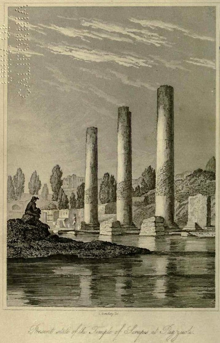
This frontispiece from Charles Lyell’s 1832 Principles of Geology shows three pillars of the Roman Macellum of Pozzuoli (Italy) with bands of boreholes left by marine Lithophaga mollusks as far as 20 ft (7 m) up the columns. After the columns were built, they descended below sea level, allowing the mollusks to bore into them. They were then uplifted to today’s elevation.
Credit: Charles Lyell, public domain, via Wikimedia Commons - Between 1968 and 1972, the Campi Flegrei area rose by 5.5 ft (1.7 m), then rose again by nearly 6 ft (1.8 m) between 1982 and 1984. In the past decade, the port of Pozzuoli has risen 3 ft (90 cm), for a total increase in elevation of around 11.5 ft (3.5 m) since the 1960s.
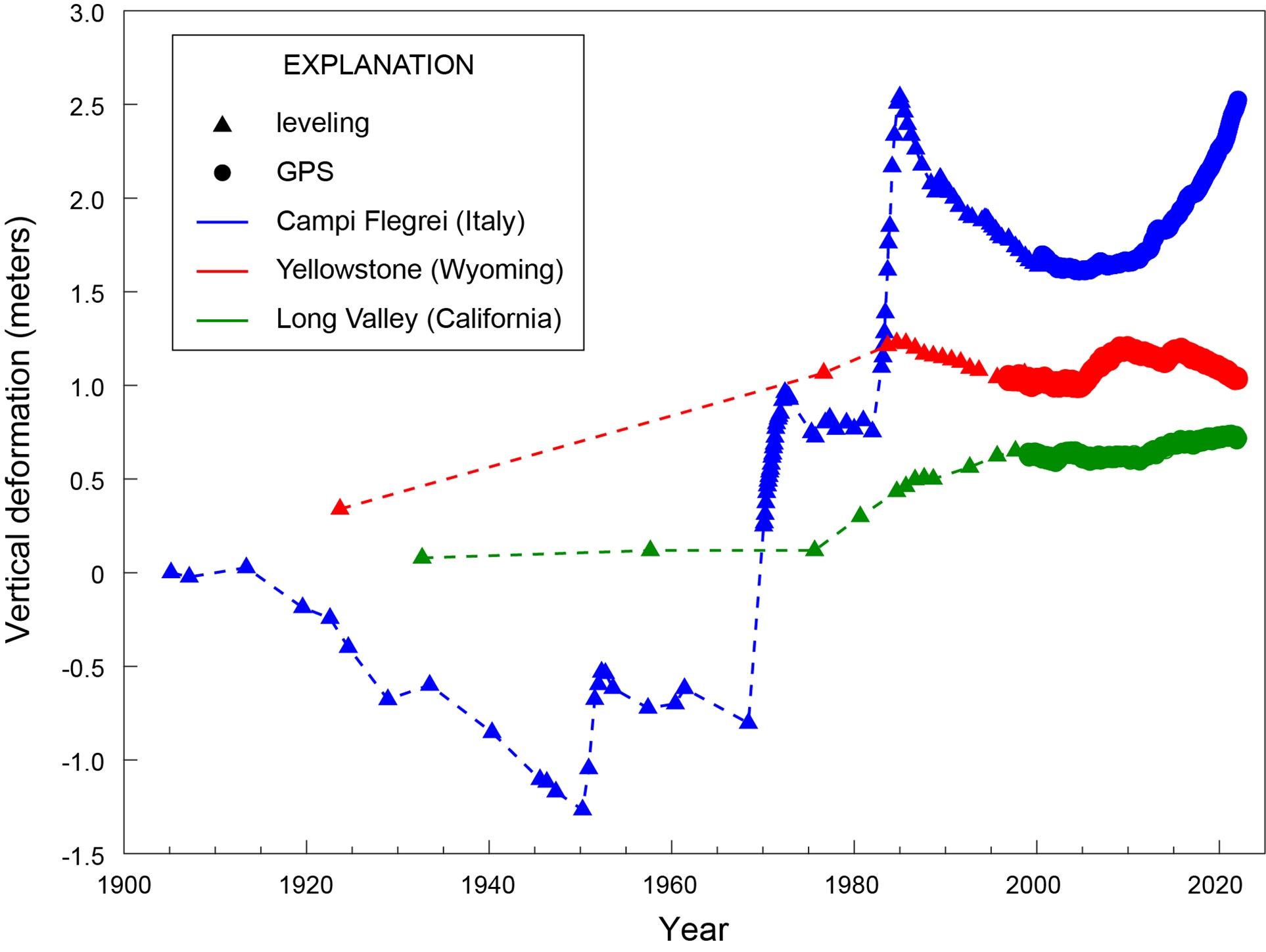
Vertical deformation measured at three caldera systems: Yellowstone, Wyoming (red), Long Valley, California (green), and Campi Flegrei, Italy (blue). Triangles show data collected by leveling and circles by GPS. All three calderas have gone up and down over time, but the scale of change at Campi Flegrei dwarfs that at Yellowstone and Long Valley.
Credit: USGS - Immediately prior to the 1538 Monte Nuovo eruption, scientists have calculated that the ground surface at the site rose as much as 66 ft (20 m).
- The caldera at Campi Flegrei measures between 7 and 9 mi (12–14 km) in diameter, while Yellowstone is four to five times larger at 30 to 45 mi (48–72 km) across. (Yellowstone’s eruption 640,000 years ago produced more than 240 mi3 [1,000 km3] of ejecta, making it a VEI-8 eruption.)
- Just over 1,000 people live in Yellowstone Park within 20 mi (30 km) of the caldera, while around 3.6 million people live that close to Campi Flegrei.
- Campi Flegrei is the most densely populated volcanic area on Earth.
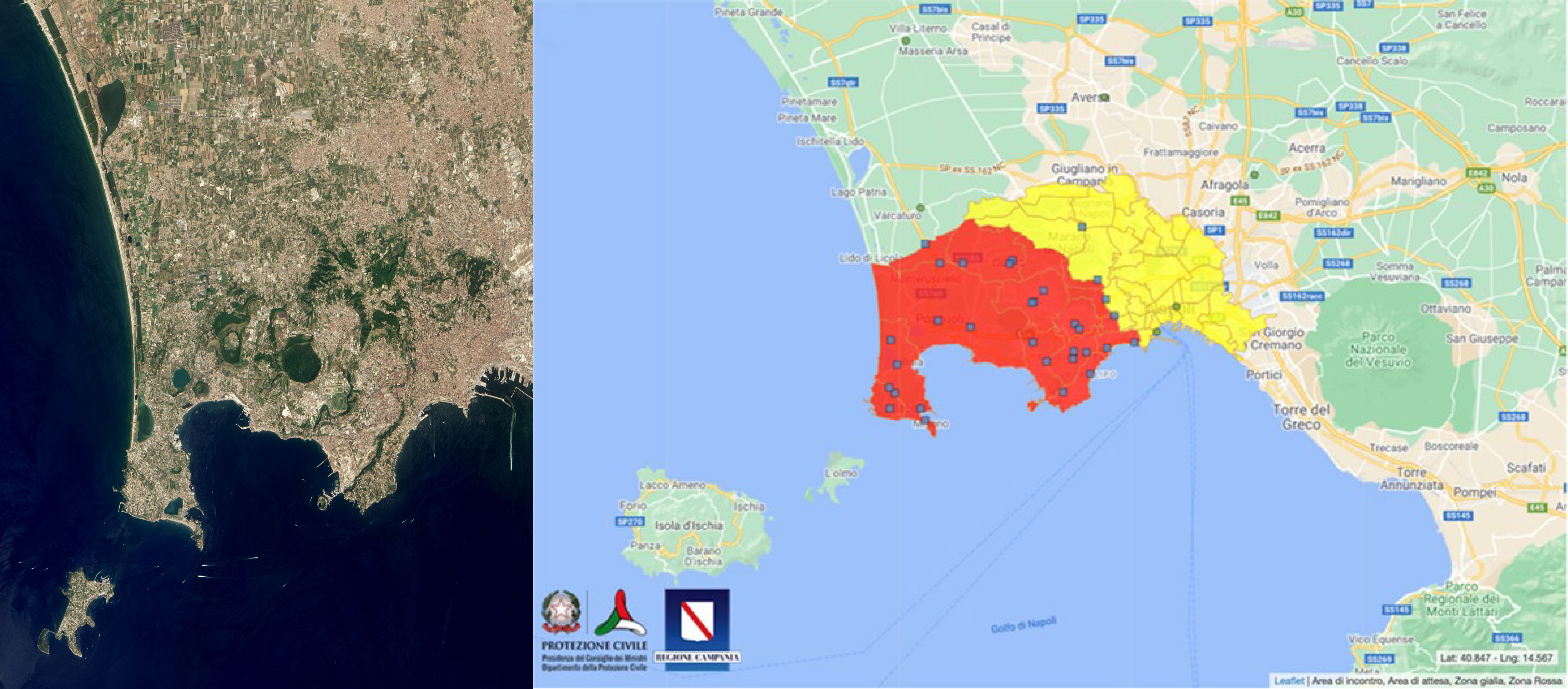
Left: This NASA Earth Observatory image uses data from the Earth Observing-1 Advanced Land Imager to show the densely populated area within the Campi Flegrei caldera.
Left Credit: NASA Earth Observatory
Right: This Italian Civil Protection Department map shows the high-risk areas associated with Campi Flegrei, and blue squares indicate the locations of phased evacuation sites.
Right Credit: The Civil Protection Department of the Italian Government - Around 500,000 people live in the red zone (“zona rossa” in Italian) that might be prone to fast-moving, high-temperature pyroclastic flows. They would be evacuated immediately upon alert. About 800,000 people live in the yellow zone (“zona gialla” in Italian), which is an area that might need evacuation depending on the intensity of ashfall.
- Campi Flegrei’s ground deformation, gas output, thermal readings, gravity field, and tremors are constantly monitored by Italy’s National Institute of Geophysics and Volcanology at the nearby Vesuvius Observatory.