Today you can take a train, in a tunnel beneath the English Channel called the Chunnel, from London to Paris in 2 hours.
But half a million years ago, the English Channel didn’t exist: Britain was attached to Europe.
At that time, Earth alternated between glacial and interglacial periods, as it still does today.
During glacial periods, some of Earth’s water is held in vast glaciers, on top of continents rather than in oceans, which causes ocean levels to drop hundreds of feet.
Toward the end of one of these glacials, as the ice sheets started to melt, an enormous lake formed in the North Sea—dammed in the north by a massive wall of ice and in the south by a rock land bridge.
Eventually water levels rose so high that the lake began pouring over the British land bridge in gargantuan waterfalls.
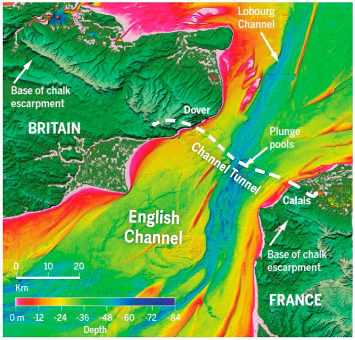
Engineers planning the path of the Chunnel discovered this. Using seismic studies, they found huge, deep pits in the seafloor filled with rubble and sediment, and designed the Chunnel to avoid them.
Eventually scientists collected enough data to recognize the pits as plunge pools that those giant waterfalls would have made from millions of tons of water, pounding down on the seafloor over centuries.
The waterfalls began to erode the land bridge, but it held—until, a couple of glacial and interglacial cycles later, another flood finished the job.
The channel formed—causing a natural Brexit thousands of years ago.
Background
Synopsis: The map of Europe includes two major landmasses: continental Europe and the island of Great Britain. Politically today, Britain is in the process of separating its affairs from the rest of Europe. But less than half a million years ago, Great Britain even more drastically exited from Europe, becoming an island nation when the Dover Strait opened to connect the English Channel to the North Sea!
- Today the shortest distance between Britain and Europe is just 20.7 miles (33.3 km) at the Strait of Dover, where the northeastern end of the English Channel meets the North Sea. The average water depth in the Strait is about 98 ft (30 m).
- If skies are clear, it is possible to see structures on the opposite coastline with the naked eye.
- During World War II’s Battle of Dunkirk, which took place May 26–June 4, 1940, about 850 private boats sailed across the Strait of Dover from the town of Ramsgate in England to rescue more than 336,000 British and French Soldiers trapped on the beaches near the village of Dunkerque in France. The French call the channel La Manche.
- Originally conceived in 1802, the Channel Tunnel, or “Chunnel,” was constructed for high-speed train travel under the Strait of Dover from 1988 to 1994. Its three adjacent tunnels are 31 miles (50 km) long and run as much as 250 ft (75 m) below the seabed, or 380 ft (115 m) below sea level.
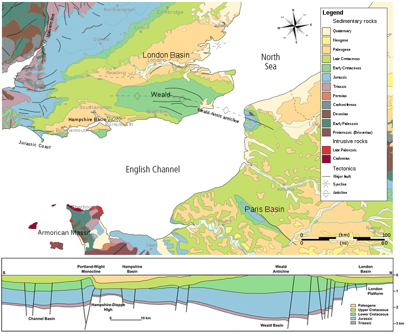
- Until about 425,000 years ago, Great Britain was a peninsula—larger than but similar to present-day Denmark—jutting northward from Europe.
- Connecting the two landmasses was a narrow isthmus along a geologic feature known as the Weald–Artois anticline.
- This anticline formed about 15–25 million years ago as part of the much larger and longer-lived Alpine orogeny, warping thick white 70 million-year-old Cretaceous chalk and neighboring sediments into a large fold 120 miles (200 km) long and 20–40 miles (32–65 km) wide, which protruded nearly 600 ft (183 m) above the surrounding area.
- The anticline crosses the English Channel near the Dover Strait, between the 360-ft (110-m) high White Cliffs of Dover in England and the 150-ft (45-m) high Cap Blanc Nez near Calais in France.
- Over the past half-million years, sea level on Earth has varied dramatically through five complete glacial–interglacial cycles.
- During glacial periods, with vast continental ice sheets locking up much of Earth’s water, sea level dropped as much as 300–400 ft (90–120 m) below current levels, repeatedly leaving much of Earth’s continental shelf exposed and causing rivers and deltas to migrate seaward.
- During the interglacials, like today, sea level ranged up to 20 ft (6 m) higher than today’s sea level. Highstands often inundated land bridges and isolated landmasses from each other.
- The Dover–Calais land bridge was high enough to connect Britain to France even during the highest sea levels, until the Dover Straits opened up about 425,000 years ago.
- Two clear lines of scientific thought developed regarding how Great Britain became separated from mainland Europe: slow downcutting by normal rivers, or breaching of the anticline by catastrophic flooding.
- In 1985, while preparing to drill the Channel Tunnel, engineers found rubble and unconsolidated sediment in some areas—a collapse hazard that forced engineers to adjust the tunnel’s course.
- Seismic surveys showed that the loose fill occurred in deep, oddly shaped basins. Alec Smith of Royal Holloway, University of London, was the first to suggest that catastrophic flooding created these odd features, which reminded him of plunge pools that form as water relentlessly pounds rocks below waterfalls.
- In 2003, researchers from Imperial College acquired a state-of-the-art bathymetric survey tool.
- This multibeam acoustic imaging equipment could image 10 times more seabed in a single swath than older tools but needed to be tested; the English Channel was the chosen site.
- Rather than a boring sea bottom covered in sand and gravel, researchers instead imaged a bedrock floored landscape, as fresh as the day it had been cut! Over the next decade, further state-of-the-art bathymetric and seismic surveys showed the features in even greater detail:
- A huge, straight, vertical-sided valley that cut more than 150 ft (50 m) across the anticlinal ridge
- Streamlined islands and longitudinal grooves eroded into bedrock, indicating that massive, high-flow-rate discharges of water occurred across exposed bedrock
- Deep, curved amphitheater-shaped pits and plunge pools that line up for 4.5 miles (7km) along the far side of anticlinal ridge. These features are nearly a half mile in diameter (1 km) and cut 450 ft (140 m) deep into solid bedrock.
- Yet another huge, deep, straight valley, the Lobourg Channel, that cut across the plunge pools, indicating that a second catastrophic event ripped through the bedrock after the pools had filled with sediment
- Blind river channels that point to the Dover Strait but then abruptly stop
- Dendritic drainage systems preserved on the floor of the channel, showing that typical river processes also operated during times when the channel floor was exposed
- Sedimentologic and paleontologic studies provided clues that the huge North Sea Basin—about twice the size of Texas—had been a Pleistocene glacial lake, separated from the English Channel and Atlantic Ocean.
- Unique minerals derived from Alpine erosion were only found in the North Sea Basin; they had not been transported further toward the Atlantic.
- Likewise, certain species of mollusks were isolated within the North Sea Basin.
While researchers drilled into submarine fans at the Atlantic mouth of the English Channel, two thick deep-sea sediment packages were discovered, recording two dramatic depositional events that probably coincided with the flooding.
- Both catastrophic and normal processes had contributed to the creation of the island of Great Britain, probably, according to researchers, in this way:
- About 450,000 years ago, the British and Scandinavian continental ice sheets coalesced during a protracted and intense glacial period.
- As an interglacial stage began 425,000 years ago, glacial meltwater from the north and river discharge from European rivers to the south started filling the basin, trapped by the towering glaciers to the north and the 600-ft-high isthmus of chalk that dammed the southwest corner of the lake.
- Eventually, this North Sea lake must have filled to the point that water started spilling over the chalk ridge, creating a line of huge waterfalls and eroding deep plunge pools on the exposed western side of the land bridge.
- We know from man-made dams that impoundment of water changes stress in Earth’s crust, sometimes creating earthquakes—which could have happened here.
- With the deep erosion on the downstream side of the dam and the increasing volume of glacial meltwater, the land bridge started breaking down and finally gave way.
- Using the size, slope, and ruggedness of the incised valley, scientists estimate that a catastrophic flood of up to a million tons of water per second poured through the ruptured ridge toward the Atlantic, cutting into the bedrock to create deep grooves and streamlined shapes of islands of rock that remained between the scours.
- The North Sea lake may have only partially emptied during this event. During glacial intervals, parts of the broken land bridge were probably above sea level, because hominid and large mammal migration between Britain and Europe continued.
- The vestiges of branching river systems are also visible on the floor of the English Channel, indicating that normal fluvial erosion and drainage occurred after the catastrophic flooding.
- After a couple of glacial–interglacial cycles, the event repeated itself, this time widening the straits and scouring a channel that began in the North Sea and roared right across the Dover Strait and some of the plunge pools created in the earlier flood.
- The megaflood is important to understand for a variety of reasons.
- It changed the course of rivers and deltas in northwestern Europe. For example, the Thames River used to be a tributary of the Rhine River, but now waters from both rivers flow into the North Sea near the Strait of Dover.
- Freshwater floods of this magnitude may have affected the thermohaline ocean circulation in the Atlantic, thus dramatically affecting climate.
- The land bridge was important for the migration of hominids and large mammals between Europe and Britain.
- 700,000 years ago, large numbers of Homo heidelbergensis and big mammals lived in Britain. Colonization continued after the first flood, but after the final flood, both horses and hominids seem to have disappeared from Britain until Neanderthals arrived about 120,000 years ago during a time when glaciation caused very low sea levels.