In school, we learned the continents: the Americas, Eurasia, Africa, Australia, and Antarctica—with island nations like New Zealand floating off by themselves.
So you may be surprised to hear that scientists have discovered a new continent—and New Zealand is part of it, after all. In fact, it’s one of the only parts of what’s now called Zealandia that’s above sea level.
Most of Zealandia, which is almost two-thirds as big as the continental United States, is more than a kilometer underwater.
That’s deep enough that you might be thinking, “That doesn’t sound like a continent.” Except the seafloor around it is 4 kilometers deep.
Antarctica, too, if you melted all the ice, would be just a few islands, with most of the western part of the continent submerged.
Which begs the question: what exactly makes a continent? The leading factors are its mineral content and density.
The seafloor is dense and heavy with iron, so it rides low in the mantle that supports all of Earth’s crust.
Continental crust is high in silica and aluminum. It’s less dense and much thicker than oceanic crust, so it floats higher in the mantle, like ice on a lake.
Most continents are large landmasses surrounded by a shallow ocean shelf.
But Zealandia is a small landmass surrounded by a large ocean shelf, having been pushed around, squeezed, then sunk by plate tectonic forces over millions of years.
Background
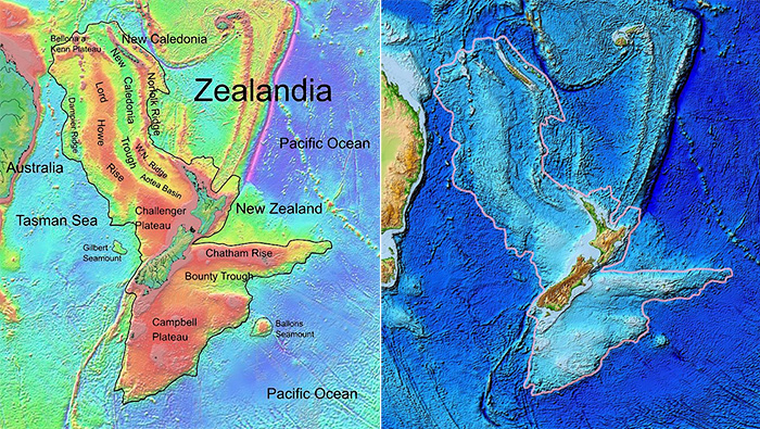
Synopsis: When we think about the continents on Earth, we go back to the landmasses we learned about in school, but if you drained the oceans, you would see a very large, prominent area east of Australia that includes New Zealand and New Caledonia, along with the area of rugged, relatively shallow seafloor that surrounds them. The area is about two-thirds the size of Australia, making it about 60% of the size of the lower 48 U.S. states. In 2017, scientists proposed that the area should be considered as an additional continent— Zealandia. What makes it a continent, and why does it matter?
- Zealandia was first recognized about 50 years ago. Some data was collected in 1971, but the region was originally thought to be a collection of oceanic and continental fragments. After 20 years of work, scientists have now reclassified it as an intact continent.
- In August and September 2017, Expedition 371 of the International Ocean Discovery Program (IODP) began the exciting job of exploring this previously unexplored continent in earnest.
- After 4 days’ sail from the nearest port, they drilled six core holes into and around the new continent in water depths ranging from 1,200 to nearly 5,000 m to answer some big scientific questions about how the continent formed and how it may have influenced past ocean circulation.
- With at total crew of 127, 32 scientists from 12 countries participated on the famous JOIDES Resolution research ship.
- Why didn’t we notice Zealandia before? As is the case with most of the oceans, the seafloor of Zealandia is mapped less precisely than the surface of the moon. However, recent work with satellite data provides continuous map coverage at about 5-km resolution, allowing a larger view of the region.
- What criteria define a continent, and how does Zealandia compare?
- Continents and their shelves are elevated above the ocean floor.
- While most continents have large landmasses and thin continental shelves, Zealandia has small landmasses and large continental shelves.
- Most of the Zealandia shelf is 1–2 km below sea level, compared to the average 3.7 km depth of the ocean floor.
- If West Antarctica were not covered with ice, much of it, after isostatic adjustment, would similarly be submerged with island chains.
- Earth has two types of crust. Aluminum–silica-rich continental crust is thicker and less dense than iron–magnesium-rich oceanic crust.
- Zealandia’s crust ranges from 10 km to 40 km thick, compared to 7-km-thick oceanic crust. Most continents are 30–46 km thick.
- Zealandia’s crust is about 8% less dense than oceanic crust; most continents are 15% less dense. This density explains why continents stick up or float in the lithosphere compared to denser oceanic crust.
- Zealandia is separated from Australia by the 3.6-km-deep Cato Trough, a transform boundary with more than 150 km of motion that links oceanic spreading centers in the Tasman and Coral seas. Although it is only 25 km wide, the Cato Trough effectively separates the continental crust both spatially and tectonically, making Zealandia an additional continent instead of an extension of the Australian continent.
- Continents have distinctive geology that goes back hundreds of millions of years.
- Although no Precambrian rocks have yet been found in Zealandia, outcrop, drill core, and seafloor dredge samples show distinctive Paleozoic and Mesozoic greywacke, schist, granite, and other siliceous continental material up to 505 million years old.
- The area of continents is well defined and generally accepted to be larger than 1 million sq km; India would have been large enough to be considered a separate continent before its collision with Eurasia.
- Zealandia is 4.9 million sq km, 63% of the size of Australia at 7.6 million sq km.
- Why is 94% of Zealandia submerged?
- More than 100 million years ago, the region was part of the supercontinent of Gondwana. Zealandia then started to break away from neighboring Australia and Antarctica, thinning the continental crust by forming rift valleys (like we see in East Africa) and finally starting to build basaltic oceanic crust about 83 million years ago, in the Late Cretaceous epoch.
- After 30 million years (early Eocene), the extensional process stopped at about the same time that the Hawaiian Island chain changed direction, indicating a change in the rotational pole of the Pacific Plate.
- With this direction change, the Pacific Plate started compressing the Zealandia region for about 20 million years, causing the initiation of a new subduction zone, eventually called the Tonga–Kermadec Trench, along what we now refer to as the Pacific Ring of Fire.
- While under compression, Zealandia began emerging in the early Eocene, first below the waves, then popping up above sea level.
- As the trench became established in the early Oligocene, compressional forces were relieved and Zealandia’s tortured continental crust began sinking back below the waves, too thin and crumpled to stand as high as regular continental crust.
- Zealandia is a missing piece of the puzzle in reconstructing earth, ocean, and atmospheric history in the South Pacific, all of which impact the history of life in the region.
- The sediments deposited in Zealandia exhibit dramatic changes in water depth and provide a vast, rich 3D record that can help answer questions about how new subduction zones form and how they impacted ocean circulation around the area over more than 50 million years.
- Zealandia is thought to have been much closer to the South Pole during its wild up-and-down Eocene ride, when Earth’s surface was 10–12°C warmer than today; scientists can use the region’s sediments to better understand polar responses to climate extremes.
- While Zealandia was exposed, plants and animals evolved and dispersed across the continent from the South Island of New Zealand to New Caledonia in the north, explaining why certain closely related species occur in these distant islands. Some of these species used to be globally distributed but now are found only on the landmasses of Zealandia.