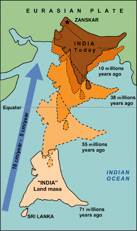
Credit: Pierre Dèzes 1999, "Tectonic and metamorphic Evolution of the Central Himalayan Domain in Southeast Zanskar (Kashmir, India)". Mémoires de Géologie (Lausanne) No. 32, ISSN 1015-3578 or the website: http://comp1.geol.unibas.ch/zanskar/, via Wikimedia Commons
What do India and Antarctica have in common? They were once part of the same landmass.
Long ago, like all land on Earth, India was contained within the supercontinent of Pangaea. But around 200 million years ago, Pangaea began to break apart. The southern portion separated into Gondwana, which included India.
India then began to set its own course. It rifted away from Africa, then tore off from Antarctica. As it traveled north, it shed Australia, then Madagascar.
This is partly because India was on the fastest-moving tectonic plate on Earth, racing along at a few inches a year and leaving the others behind.
For 20 million years, India was its own continent, but it continued to move. In the end, it traveled 1,200 miles in 150 million years—a record—until it collided with Asia and became the Indian subcontinent we know today.
Because the crusts of the two plates were similar in density, neither subducted beneath the other, but crushed together. The buckle zone between them raised the highest mountain range on Earth, the Himalayas.
As a result, you can find fossils of trilobites and other ancient sea creatures at the summit of Mount Everest!
The Indian plate is still pushing its way north, but now much more slowly, producing earthquakes while continuing to lift the Himalayas higher.
In more ways than one, India is on the rise.
Background
Synopsis: The Indian tectonic plate recorded the fastest plate motion ever documented as it raced over 1,200 mi (2,000 km) in about 150 million years from a position near Antarctica to crash into Asia, building the Himalayas. In its path, subduction zones consumed the ancient Tethys Ocean, and in its wake new rift zones created the Indian Ocean, along with a dramatic gravity low in Earth’s geoid south of India. Recent studies provide possible explanations for the longstanding puzzles of why the plate moved so fast and why the gravity low formed.
- The Indian subcontinent is the geographic region north of the Indian Ocean that includes Bangladesh, Bhutan, India, Nepal, Pakistan, Sri Lanka, and the Maldives.
- Its northern edge is defined by the Himalayas, which formed as the Indian tectonic plate crashed into Asia starting around 62 million years ago.
- The Indian plate used to be a continent with its own distinct geologic history.
- It was once part of Gondwana, the ancient southern part of the supercontinent of Pangaea, as demonstrated by fossil evidence and physiographic fit.
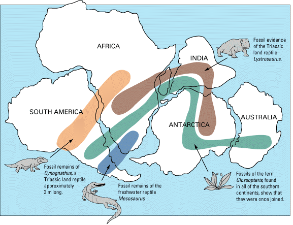
The locations of certain fossil plants and animals on present-day, widely separated continents form continuous patterns (shown by the bands of colors) if the continents are rejoined.
Credit: W. J. Kious and R. I. Tilling, 1996, This dynamic Earth: the story of plate tectonics: U.S. Geological Survey General Interest Publication Series, public domain - From late Paleozoic to very late Triassic (300–200 Ma), Pangaea crowded one side of the globe.
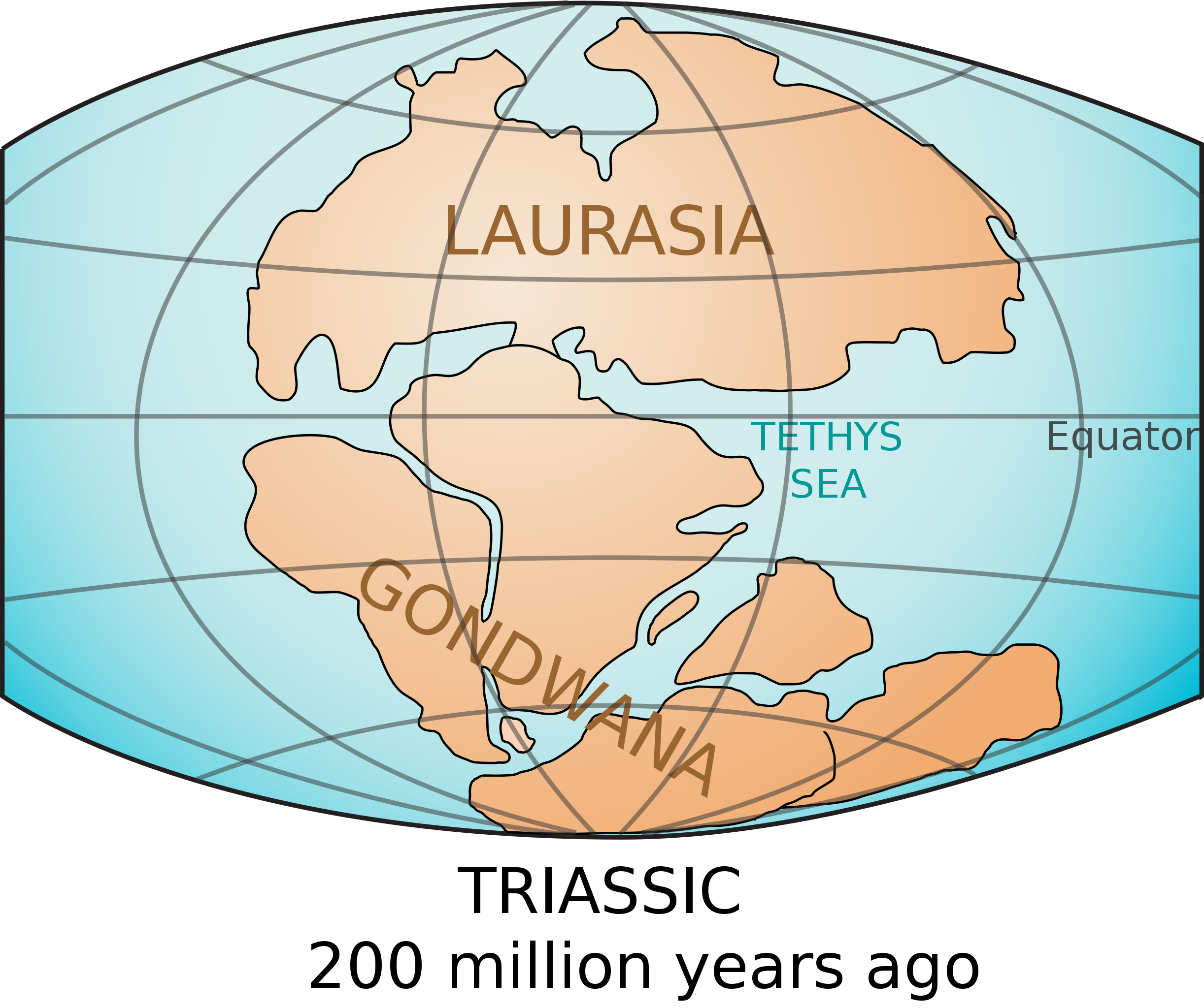
The continents Laurasia and Gondwana formed the supercontinent of Pangaea from 300 to 200 million years ago.
Credit: Lennart Kudling, CC BY 3.0, via Wikimedia Commons - Then, around 200 million years ago, Pangaea began to break up.
- Starting 150 to 120 million years ago, the Indian plate rifted away from Africa, then away from Antarctica, Australia and, finally, from Madagascar
- In this early stage it moved at a rate of about 1.6 in/yr (4 cm/yr).
- It was once part of Gondwana, the ancient southern part of the supercontinent of Pangaea, as demonstrated by fossil evidence and physiographic fit.
- About 80 million years ago (Late Cretaceous Campanian), the Indian plate sped up, plowing northward in response to a combination of spreading ridges to its south and subduction zones to its north.
- It moved across the Tethys Sea toward the Eurasian plate at around 6 in/yr (15 cm/yr).
- As the Indian plate moved, the Tethys Sea to its north was consumed in subduction zones (along with the details of its geologic history), while the Indian Ocean was created at spreading centers to its south.
- Ultimately, the plate covered a distance around 1,200 to 1,900 mi (2,000–3,000 km). This animation illustrates the plate movement through time.
- Around 62 million years ago (Paleocene), the continental Indian plate slowed as it began colliding with the continental Eurasian plate.
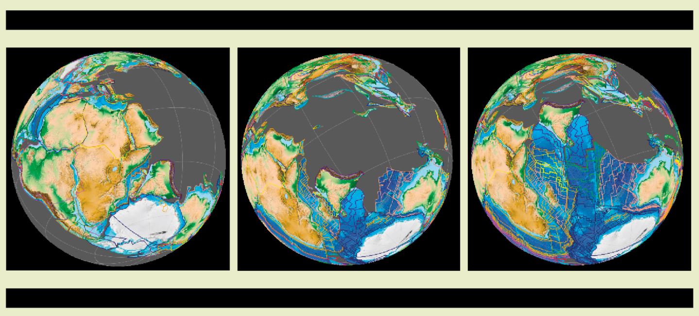
The Indian subcontinent separates from Africa around 150 million years ago (left) and from Australia, Antarctica and Madagascar by 80 million years ago (center), plowing northward through the Tethys Sea (gray) 40 million years ago (right). Modern seafloor is shown in blue while Tethys seafloor that has been subducted is shown in gray, its details forever lost to science.
Credit: Fama Clamosa, CC BY-SA 4.0, via Wikimedia Commons - Because both plates included substantial amounts of lighter continental crust, they buckled upward, faulted and folded into mountain ranges instead of being subducted.
- The Indian subcontinent may have been uplifted prior to continent-on-continent collision by successive subduction episodes of attached oceanic crust.
- The crumpled crust north of the subcontinent includes the Ordovician marine deposits of the “Qomolangma Limestone” at the crest of Himalayan Mount Everest, which includes trilobites, brachiopods, ostracods, and crinoids.
- The Indian plate is still moving northward, albeit at a slower pace, resulting in present-day earthquake activity from continued thrusting and uplift of the Himalayas and the Tibetan Plateau.
- A number of longstanding puzzles about the Indian plate’s journey still remain:
- The subduction of the Tethys seafloor erased a tremendous amount of Earth’s history.
- The intense crushing of the Himalayan collision has made it difficult to deconstruct the sequence of events over the millions of years that the Indian plate was in motion.
- The question of the plate’s rapid sprint has been the subject of research for many years.
- Hypotheses include hot jets of mantle plumes melting off the bottom half of the Indian plate or accelerating it, two separate collisions to delay the arrival of the continent-to-continent collision and errors in paleomagnetic data or interpretation.
- Recently, MIT scientists have come up with a new suggestion based on Himalayan data and modeling: double subduction zones to the north that would have pulled India northward at a much faster rate.
- The researchers studied rocks and paleomagnetic data in the Himalayas, deducing that a volcanic arc existed along the equator in the Tethys Sea about 80 million years ago along with its subduction zone.
- This arrangement of plates would mean that there were two oceanic plates being subducted, a northern one and a southern one that India rode upon.
- The northern subduction zone would pull the southern subduction zone, which would pull India, accelerating the closure between India and Eurasia.
- They also determined that oceanic plates with narrow widths, like the one that carried India, can be subducted faster.