Strange weather around the world is often blamed on El Niño. Who is this “boy,” and how does he cause so much trouble?
El Niño is simply warmer-than-normal water in the Pacific, off South America. It was first noticed by sailors in the 1600s, who named it after the Christ Child since it came in December.
We now know that El Niño lasts several months to several years, returns every 2 to 7 years, and is caused by atmospheric pressure.
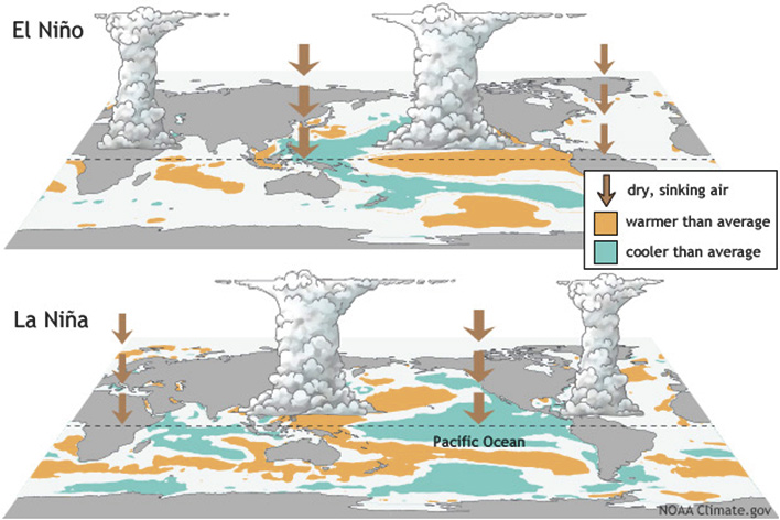
In a normal year, high pressure over the Pacific and low pressure over Australia and Indonesia form trade winds. These blow west across the Pacific, pushing warm surface water with them—which brings humidity and rain to Australia.
Meanwhile, cold water from the deep replaces the exiting warm water, replenishing nutrients and fish stocks along South America.
But in an El Niño year, the high- and low-pressure areas are reversed, and trade winds stop.
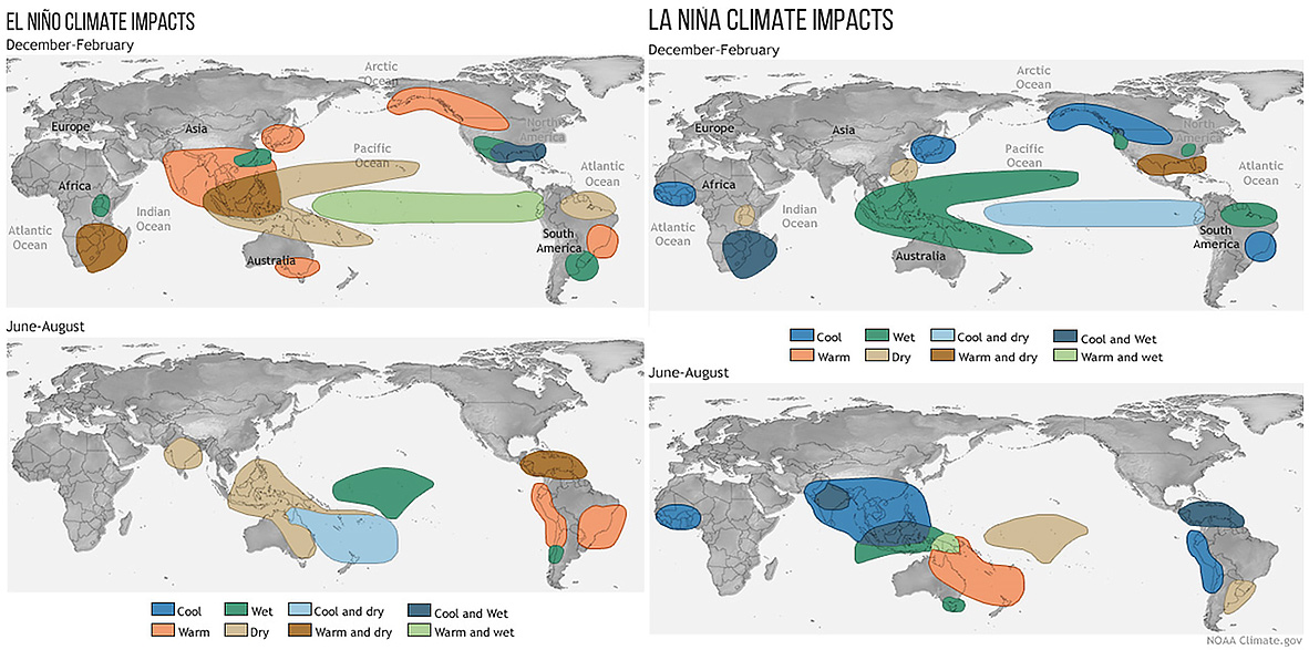
Warm water stays put. Australia and Indonesia get less rain. South America gets it instead.
The shifting temperature patterns alter the jet stream, which changes the tracks of seasonal rains.
This makes it warmer and drier in the northern U.S. and Canada. Colder and wetter in the southern U.S. And causes droughts as far away as India.
La Niña is a natural compensation—colder-than-normal water in the western Pacific—which sometimes follows El Niño and brings opposite weather effects.
Background
Synopsis: How does El Niño affect weather around the world?
- Oceans cover more than 70% of Earth’s surface. The surface area of the Pacific Ocean represents half of that, blanketing about a third of the globe.
- Energy from sunlight impinging on this huge area is stored as heat in the ocean, creating variations in atmospheric pressure that result in trade winds blowing from the east, converging along the equator from 30 degrees north to 30 degrees south latitude.
- Winds contribute to ocean currents, but ocean circulation is far more complex because temperature, salinity, and chemical and nutrient concentrations all vary in three dimensions in ocean water, driving their own fronts and currents in the hydrosphere and acting as vital influences on marine life.
- Interconnection of the atmosphere and hydrosphere in the Pacific region affects weather globally.
- In 1924, Sir Gilbert Walker described cyclical changes in atmospheric pressure at sea level across Indonesia and tropical Pacific islands as the Southern Oscillation.
- In the 1960s, meteorologist Jacob Bjerknes and others realized that oceanic and atmospheric changes were linked, a pattern they referred to as El Niño–Southern Oscillation (ENSO).
- ENSO is a coupled climate phenomenon with three phases: cool “La Niña” and warm “El Niño” are the two extremes that impact both the atmosphere and ocean systems. A neutral phase occurs between the two or when variations are seen only in one of the systems.
- ENSO is a long-term climate oscillation; scientists have mixed views about how increasing global temperatures related to climate change will impact it in the future.
- Satellites are used to track surface water elevation and temperature and to collect 3D ocean information from drifting buoys equipped with instruments that cycle up and down in the water column.
- Under normal or neutral conditions, trade winds converge along the equator and drive warm water westward toward Southeast Asia and Australia.
- As these easterly winds push water toward the west, the Coriolis effect—a result of Earth’s rotation—causes water to deflect north and south away from the equator, setting up currents that mix the warm water into a broad pool with depths of more than 500 ft.
- Under neutral conditions, the surface of the Pacific near Indonesia runs about 14ºF warmer than near the coast of northern South America; here, sea level is 15–20 inches higher because of thermal expansion of the water and the action of the wind.
- As the sea surface warms, the atmosphere above it is heated and becomes more buoyant, decreasing atmospheric pressure and further enhancing the winds.
- Warmer water results in more condensation, causing clouds to form in low-pressure systems that drive wet weather and monsoons that are typical on the tropical western side of the Pacific.
- In the eastern Pacific, cooler water from deep in the ocean fills in behind the westward-moving warm water, upwelling toward the surface and bringing nutrients essential for the fertile fisheries along the western coast of the Americas.
- The cold, upwelling seawater cools the air above it, favoring high-pressure systems that render coastal regions in Central and South Americas arid.
- Winds blow from the high-pressure systems in the east toward the low-pressure systems in the west, further strengthening the normal trade winds.
- If trade winds become very strong, the pendulum swings to the “La Niña” effect.
- Stronger easterly trade winds pile up more warm water between Australia and Indonesia, driving currents that circle Australia and intensify western Pacific rains.
- Increased upwelling of cooler water along the coast of the Americas cools Pacific equatorial waters, which is beneficial for fisheries but also increases the intensity and extent of eastern Pacific regional drought patterns onshore.
- Every 2 to 7 years, the pendulum swings to the “El Niño” effect. Scientists are still trying to figure out what triggers it.
- The easterly equatorial trade winds weaken, sometimes even switching directions to blow from the west.
- Without strong trade winds pushing it westward, warm water piled up in the western Pacific sloshes back toward the Americas.
- This huge quantity of warm water drags wet weather systems eastward away from Asia and stifles upwelling along the coasts of South and Central America, shutting down or reversing coastal and equatorial currents.
- The annual average global temperature increases slightly as the warm water spreads out and heats the atmosphere across the equatorial Pacific.
- The changes flip normal global weather patterns, causing floods in typically arid regions of the western Americas, and droughts and wildfires in normally tropical areas of Southeast Asia and Australia.
- El Niño systems increase the wind shear—a limiting factor for the initiation of hurricanes—over the Atlantic and Caribbean, leading to a reduction of storm activity there. The opposite occurs over the eastern Pacific, where storm activity increases.
- As coastal currents and upwelling change, cold nutrient-rich water is suppressed and primary productivity from phytoplankton drops dramatically, which can cause widespread collapse of commercial fisheries on the west coast of the Americas.
- History suggests that El Niño events have probably occurred for thousands of years.
- Geologists see evidence of El Niño floods in Peru dating back 40,000 years.
- Ancient records indicate that high priests of the Inca Empire may have sacrificed humans to prevent rains and floods associated with El Niño.
- In the 16th century, conquistadors were able to penetrate farther into the heart of South America because of wet El Niño conditions in the brutal coastal deserts.
- Poor crop yields as far away as Europe have been correlated to El Niño years, leading to multiple famines and probably triggering the French Revolution.
- El Niño–linked famine in northern China killed more than 13 million people in 1876.
- In 1998, a very intense El Niño event warmed waters six times as much as typical El Niños and caused about 16% of the world’s reef systems to die.
- Wildfires caused by drought in 2015–16 contributed to as many as 100,000 deaths and extensive property damage.