
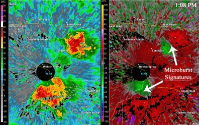
Credit: By US National Weather Service - https://www.weather.gov/images/bmx/Daily/microbursts/radar.gif from article What is a Microburst?, Public Domain, https://commons.wikimedia.org/w/index.php?curid=108049434
Background
Synopsis: Downbursts are powerful winds that fall straight out of thunderstorms and spread outward across the ground, often causing damage mistaken for tornadoes. Understanding how downbursts and microbursts form, why they produce destructive straight-line winds, and advances in weather science have improved storm detection and aviation safety.
Devastation
- Imagine a wide path of trees flattened to the ground, trunks snapped and lying in the same direction. Nearby, houses have shattered windows, torn siding, and pieces of roofing, sometimes even entire roofs, scattered across yards and streets.
- Or imagine the surge of adrenaline felt by a pilot guiding a plane full of summer travelers toward the runway, when the aircraft is suddenly forced downward, struggling to maintain altitude and speed just seconds before landing.
- Or imagine the surge of adrenaline felt by a pilot guiding a plane full of summer travelers toward the runway, when the aircraft is suddenly forced downward, struggling to maintain altitude and speed just seconds before landing.
- What could cause such frightening events? Many would suspect a tornado or perhaps a hurricane. But the culprit here is less familiar and far more widespread: a phenomenon known as a downburst.
What is a Downburst?
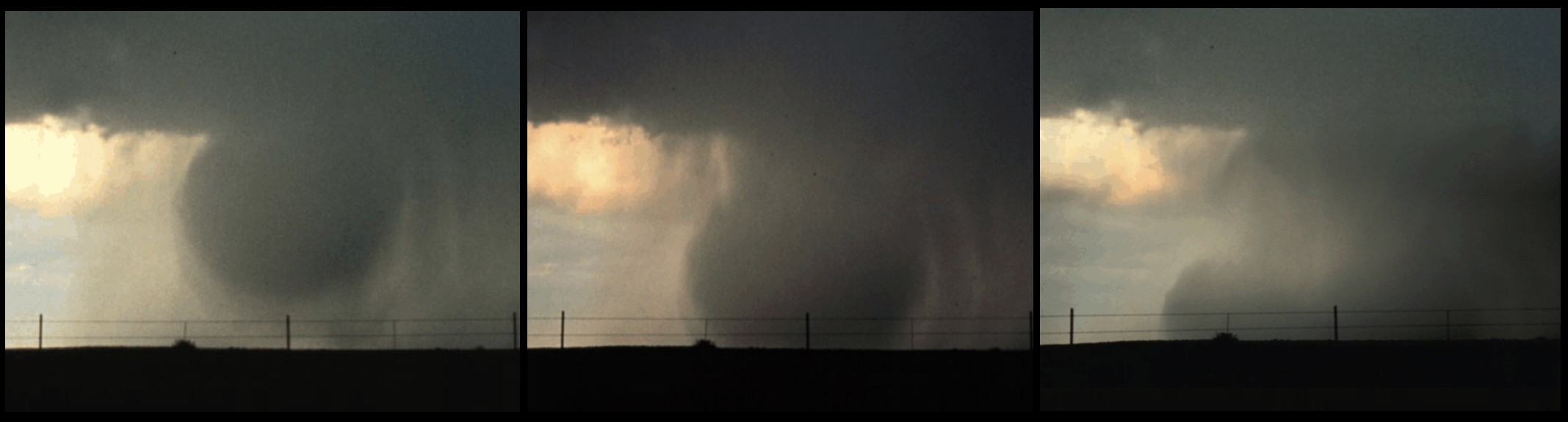
- A downburst is a powerful column of sinking air inside a thunderstorm. The air accelerates rapidly toward the ground, then spreads outward in all directions when it hits the surface.
- EarthDate episode 320, Raising Hail, describes how thunderstorms form as warm, humid air rises in a strong updraft. This vertical motion builds towering cumulonimbus clouds and suspends growing raindrops and hail within the storm.
- As precipitation becomes heavier, or as the storm begins to weaken, this suspended rain and hail can suddenly plunge downward.
- Like weak tornadoes rated EF0 or EF1, winds from downbursts can exceed 100 miles per hour (about 160 km/hr). But the motion is entirely different.
- Tornados rotate. Downbursts slam straight down, then spread out in powerful, straight-line winds.
Credit: https://www.weather.gov/bmx/outreach_microbursts
The Physics of Falling Air
- Just the right ingredients must combine for this recipe of destruction.
- Strong updrafts feed the storm cloud, allowing it to grow larger and suspend heavy rain and hail within the storm.
- As precipitation accumulates, air within the storm begins to cool and become denser, setting the stage for a powerful downdraft.
- Cooling accelerates when dry air enters the storm, often along the backside of a thunderstorm.
- As rain evaporates and hail melts or sublimes in this dry air, a process known as evaporative cooling occurs.
- During evaporative cooling, heat is absorbed from the surrounding air, causing the air to cool, become denser, and sink more rapidly.
- This growing mass of cold, dense air accelerates downward as a concentrated column, forming the core of a downburst.
- When the vertical column of air slams the ground, it spreads out in all directions, much like water from a faucet splashing across a sink.
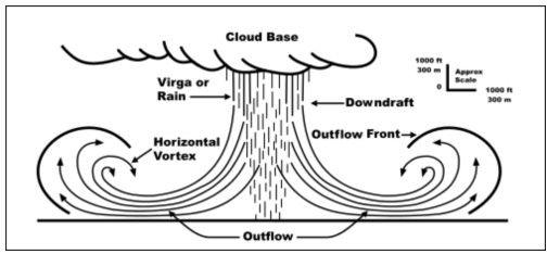
Credit: By Federal Aviation Administration (ed. D. C. Beaudette)vectored byFOX 52 - Microburstcrosssection image, Public Domain, https://commons.wikimedia.org/w/index.php?curid=46182311.
Types of Downbursts
- While many people have not heard the term downburst, they may recognize the names microburst or macroburst. These are simply size-based classifications of downbursts.
- A microburst is short-lived, typically lasting just 5 to10 minutes, but produces extremely strong winds over an area of less than about 2.5 miles (4 km).
- Microbursts can be further classified as wet or dry.
- Wet microbursts, common in the southeastern United States, are accompanied by heavy rainfall.
- Dry microbursts occur with little precipitation reaching the ground and are more common in the Great Plains and western United States.
- A macroburst covers a much larger area, lasts longer, and can also be very destructive.
Downbursts and Aviation
- Microbursts proved especially dangerous for air travel prior to the 1980s, prompting intense scientific study on their behavior.
- Near the ground, microbursts create sudden changes in wind speed and direction known as wind shear.
- During take-off or landing, this rapid shift can cause an aircraft to lose lift and descend uncontrollably within seconds.
- Several major aviation disasters in the 1970s and 1980s were later linked to microbursts including:
- Eastern Airlines Flight 66(1975), which crashed while approaching JFK Airport, killing 113 people.
- Pan American Flight 759 (1982), which lost altitude shortly after taking off from New Orleans, killing all 145 on board and 8 people on the ground.
- Delta Airlines Flight 191 (1985), which encountered a downburst while landing at Dallas-Fort Worth. The aircraft struck vehicles on a highway and a water tank before erupting into flames. A total of 135 people died in the tragedy including 126 of the 152 passengers, eight of the eleven crew members, and one motorist on the highway.
- The tragedy of the Delta Flight 191 became a turning point, leading to major advances in the understanding, detection, and monitoring of downbursts.
- Today, airports use systems such as the Low-Level Windshear Alert System to help detect dangerous wind patterns and warn pilots before it is too late.
- Even today, downbursts are often only recognized after the damage is done.
Reading the Damage
- After the storm passes, the clues it leaves behind tell a different story than a tornado.
- Downbursts produce powerful straight-line winds, rather than the rotating winds of tornadoes.
- Damage spreads outward in a 360-degree pattern from the point where the downburst strikes the ground.
- These burst patterns may span only 50 to150 yards (about 46 – 137 m), yet they can cause damage comparable to a tornado.
- When a downburst hits the surface, winds race outward and then curl upward, rotating around a horizontal axis as the air spreads away from the impact point.
- Tornadoes, by contrast, rotate around a vertical axis, pulling air inward and upward.
- Engineers now use hurricane simulators and specialized wind models to recreate downburst conditions to improve the design of transmission towers, builds, and other infrastructure.
- Winds in a downburst are often strongest just 10 to 30 feet (3 – 9 m) above the ground, placing intense stress on walls, windows, and roofs.
- While many building codes are designed for rotating tornado winds, downbursts create uneven pressure and intense vibrations, revealing vulnerabilities that engineers are still learning to address.
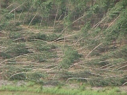
Credit: By Todd Shea, La Crosse National Weather Service Office (NOAA) - Image from the downburst case of July 27th 1998 dead link, archived https://web.archive.org/web/20061006050345/http://www.crh.noaa.gov/arx/events/june2798.php, Public Domain, https://commons.wikimedia.org/w/index.php?curid=1252174
Detection and Forecasting
- Understanding downbursts was only the first step. Detecting them in real time proved far more challenging.
- For pilots, visual cues can provide early warning.
- In arid regions, virga (precipitation that evaporates before reaching the ground) may signal a developing dry microburst. A spreading ring of dust can also be a warning sign.
- In wetter storms, the sudden appearance of a dense rain shaft may indicate a wet microburst forming, with dangerous winds close to the surface.
- Technology now plays a critical role in detection.
- Airports deploy a network of anemometers to measure rapid changes in wind speed and direction. These sensors feed data into the Low-Level Wind Shear Alert System (LLWAS), which alerts air traffic controllers and pilots.
- Terminal Doppler Weather Radar (TDWR) provides highly localized data on wind shear, precipitation, gust fronts, and microbursts near major airports.
- Since TDWR systems were installed at 46 high-capacity U.S. airports beginning in 1994, no wind-shear related accidents have occurred at these locations.
- The TDWR system will continue to be supported until it is updated with a new NextGen Surveillance and Weather Radar Capability that upgrades the system, employing a multi-function phased array, simultaneously detecting weather radar and tracking aircraft.
- Advances such as dual-polarization radar allow forecasters the ability to identify precipitation types within storms, helping them recognize the ingredients of rain, hail, and sinking, cold air that can lead to downbursts.
- When this information is used along with temperature and humidity details, forecasters can better determine where downbursts are likely to develop and where intense winds will occur.
- Even with these tools, downbursts remain fast, localized, and difficult to predict, meaning some are still only identified after the damage is done.
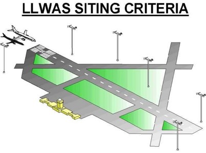
Credit: By US Federal Aeronautic Administration (FAA) - National Weather Service Aviation Weather Service Program, Public Domain, https://commons.wikimedia.org/w/index.php?curid=89311166.
Science Saves Lives
- Recognizing downbursts and understanding how they form has transformed aviation safety and severe-weather forecasting.
- The science behind these violent winds has turned once invisible dangers into detectable threats, giving pilots and communities critical time to respond.
- From shattered trees and damaged homes to safer runways and improved warnings, downbursts remind us that storms do not always twist to be deadly.
- Sometimes, the most dangerous winds come straight down, and science is what helps us see them coming.
Episode Script
In 1985, a passenger jet landing at DFW airport was forced to the ground by an unusual downward blast of wind called a downburst. The plane struck cars on the highway and a water tank, then crashed on the airfield, killing more than 100 people.
It was the third such fatal crash in a decade. So, the FAA set out to invent a new warning system for these dangerous wind events. A downburst is a sinking column of air within a thunder cloud that accelerates toward Earth, reaching speeds over 100 miles an hour.
When it strikes the ground, it blasts out in all directions, like a mammoth version of water splashing in a sink. These winds are strongest just 10 to 30 feet from the ground and travel horizontally outward in all directions. They can fell trees like a tornado’s whirling winds, but they all fall in the same direction, like dominoes.
For aviation, the first step was training pilots to look for visual signs – expanding rings of dust on the ground below, or sharply defined shafts of intense rain.
Technologically things were more complex. Vulnerable airports installed a network of wind sensors, as well as advanced Doppler radar that could track wind speeds. All fed into an early alert system.
By 1994, 46 high traffic airports had installed these systems. They haven’t had a single downburst accident since -- and technology continues to improve. A triumph of aviation safety.