On another EarthDate, we talked about the Space Race to the Moon.
NASA recruited its Gemini and Apollo astronauts from the fighter pilot program. They had nerves of steel and could make split-second decisions.
But they also needed a strong scientific background for their missions.
So NASA trained them in aerodynamics, rocket propulsion, celestial navigation, spacecraft guidance, and ultra-long-distance communication.
Most of these were about getting to the Moon. But what would they do once they got there?
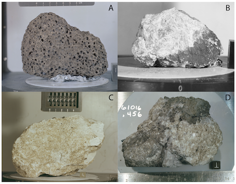
They needed to understand topography and sediments to choose a safe and stable landing spot. They needed to know which rock samples to collect and which surface features to describe and how to log what they observed so scientists could learn from it.
And for all that, they needed geology!
So NASA set up geology training camps across the American West. Not having been to the Moon, instructors used their best guesses to find places that resembled it.
Astronauts hiked the Grand Canyon, training to recognize sediment layers. They collected rock and soil samples in Texas, practiced field mapping in New Mexico, studied craters in Arizona and Alaska and volcanic structures in Oregon and Hawaii.
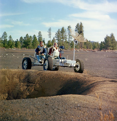
NASA even built lunar landscape simulations, blasting a field full of artificial craters where astronauts could learn to drive the moon rovers.
It’s ironic that, to make the most of their priceless time on the Moon, astronauts had to become proficient in geology—literally, the study of Earth.
Background
Synopsis: Astronauts undertake intensive training for years leading up to a launch. They study flight mechanics, rocket propulsion, aerodynamics… and geology. Because astronauts explore places that have never before been encountered by humans, practicing observational field geology on Earth improves their otherworldly decision-making, ranging from where to land a lunar module or drive a lunar rover, to which rock samples will provide the most important information for further investigation once they are delivered to earthbound laboratories.
- While early astronauts tended to be test pilots focused on flying spacecraft and getting a man to the Moon, later Apollo astronaut crews were a mix of fighter pilots, engineers, and scientists with added scientific goals.
- The technological race to invent, build, and test the machinery required to get a man to the Moon drove most of the goals of the Mercury, Gemini, and early Apollo missions.
- In 1962, as they contemplated a future moon landing, NASA officials began considering what might be learned about the Moon through scientific experiments.
- In addition to orbital experiments conducted in space, surface-based scientific investigations were carried out on Apollo 11 and the remaining moon missions.
- These studies included geological specimen collection and surface experiments as well as deployment of seismic, heat flow, and gravity tools for longer-term monitoring programs.
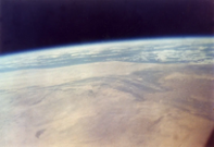
- The first American scientific data ever collected during manned spaceflight was a photo.
- John Glenn became the first American to orbit Earth on February 20, 1962, travelling for just under 5 hours in a Mercury spacecraft until his Friendship 7 module splashed down in the ocean.
- Before his launch, Glenn purchased a Minolta Hi-Matic camera, one of the first hand-held automatic cameras available, for $45 from a local drugstore. NASA engineers adapted it for use during his historic spaceflight.
- He photographed deserts, cloud formations, and sunsets, capturing public interest by providing a view of what it was like to experience Earth’s beauty from the viewpoint of an astronaut.
- Glenn later served as a United States senator from Ohio for 25 years, and in 1998, at age 77, he flew again in the space shuttle Discovery, setting a record as the oldest astronaut and providing critical data to NASA regarding seniors in space.
- Following Glenn’s Mercury mission, in mid-March 1962, the Ad Hoc Committee on Scientific Task and Training for Man-in-Space was set up to train future astronauts.
- Astronauts studied physics, aerodynamics, spacecraft navigation, guidance and control, communication, and physiology. They learned celestial navigation in planetariums.
- Initially, NASA identified specific geological questions related to proposed landing sites, including lunar topography, the nature of lunar soil, and the radiation environment. But additional benefits soon became clear.
- Many trainees had been selected from the ranks of fighter pilots and understood the importance of being able to make quick decisions with limited information. These astronauts quickly understood that gaining an understanding of Earth geology provided them with geological visual cues to aid instantaneous decision-making when piloting lunar vehicles.
- Working in geological settings also provided a theater for testing full-size models of spacecraft and practicing things like entering and exiting the vehicles.
- To improve our understanding of the origin of the Moon and its relationship to Earth, astronauts had to serve as the eyes and hands of earthbound scientists.
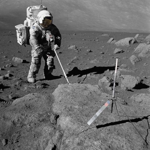
- Astronauts needed to know enough to ask the right scientific questions to make the most effective use of their priceless time on the lunar surface.
- Sample collection equipment ranging from specialized scoops to hammers, drills, and sample bags were developed for use in the lunar environment.
- Protocols for lunar sample selection, geological and geophysical methods, surveying, and documentation were developed.
- Procedures for collecting samples, driving core tubes, and describing geological sites had to be practiced over and over by the astronauts on Earth until they became ingrained as second nature.
- The first astronaut training program included a lot of classroom-based academic topics, but it quickly became obvious that astronauts were much more enthusiastic about hands-on field-based instruction and experiencing geological concepts in person.
- Training locations needed to resemble places on the Moon, but without having been there, it was a guessing game for instructors to pick the most effective sites to illustrate fundamental concepts.
- Numerous locations were selected to ensure astronauts saw the widest variety of settings possible, with local experts joining the training teams for specific sites.
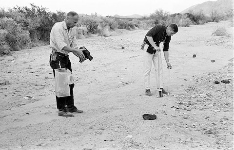
- March 5–6, 1964, marked the first field excursion for the first class of astronauts in Arizona’s Grand Canyon.
- After studying aerial photos, Armstrong, Aldrin, and their classmates were introduced to basic geoscience principles and rock types as they walked down the Kaibab Trail, then were asked to identify these rock units on a hike up the Bright Angel Trail.
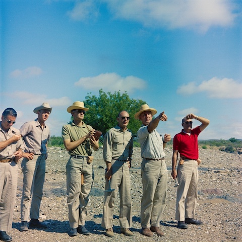
- In April 1964, they visited Big Bend National Park in West Texas, starting with a flyover to see the geological features from the air. They visited outcrops of huge folds and faults as well as igneous intrusions, volcanic lavas, and ash flows.
- In Flagstaff, Arizona, and Philmont Ranch, New Mexico, they learned how geologists create maps.
- In fall 1964, the class focused on observing volcanic features in Oregon, New Mexico, and Hawaii.
- In early 1965, they visited the Nevada Test Site to view manmade craters and traveled to Arizona’s Meteor Crater with Gene Shoemaker to study the anatomy of a real impact crater.
- Summer 1965 started with a look at more craters in Katmai, Alaska, and then a trip to Iceland to see a variety of volcanic features and lava flows.
- Additional field trips occurred in places like West Texas, Mexico, and California.
- After their initial observational trips, astronauts were charged with active geological interpretation and field work.
- Trips began to require astronauts to complete independent mapping; communicate using geological vocabulary; and plan, lay out, and gather data for traverses all while maximizing time efficiency.
- Eventually, field exercises were developed to mimic specific missions, with astronauts communicating their observations by radio to scientists who could not see them. The confined scientists and astronaut explorers exchanged observations and questions while other scientists observed them, critiquing their communication to improve its future effectiveness.
- These same training teams, which included flight controllers, other astronauts, and geologists, would communicate during each of the Apollo lunar surface missions. This mode of operation was particularly refined and effective for the final three missions (15, 16, and 17) that were focused on lunar geology. It is still being employed in modern astronaut field-based training.
- Even though they would not walk on the lunar surface, pilots of the Apollo command modules performed orbital experiments and photography while orbiting and waiting for the lander rendezvous, so the flyovers and ground checking were particularly important for them.
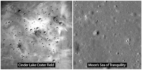
- In summer 1967, NASA and the USGS constructed Cinder Lake Crater Field near Flagstaff Arizona to mimic the lunar surface near the proposed Apollo 11 landing site.
- 143 craters were blasted into the 500-ft-by-500-ft (150 m by 150 m) site, enabling trainees to explore the pockmarked terrain and test out lunar rovers in advance of expeditions.
- Additional smaller training grounds were constructed near space centers in Texas and Florida.
- Though Apollo 11 astronauts only spent about 2.5 hours outside of their lunar module, later missions were designed with far more time for scientific investigations.
- Apollo 12, 13, and 14 were designed to put the space vehicles through more paces regarding lunar landing technology, with gradually increasing scientific goals. Apollo 13 returned to Earth after an onboard explosion, and its experiments were performed during the Apollo 14 mission.
- Apollo 15 was the first mission with a lunar rover. On August 1, 1971, Commander David Scott became the first person to drive on the Moon. With the rover and 19 hours of extravehicular activity dedicated to scientific investigations, astronauts collected and returned 170 lb (77 kg) of lunar samples to Earth from the flat mare surface at the base of the lunar Apennine Mountains and along the rim of a deep gorge, Hadley Rille.
- Apollo 16 targeted landing in more rugged highland terrain and used the rover to sample ejecta from two nearby impact craters. Upon arrival, the astronauts recognized that the geology of the site did not match what they had been told to expect and had trained to encounter. Nevertheless, their prior field training gave them the experience they needed to change plans in real time and come away with valuable observations and samples that were later used to reinterpret the site.
- The final mission in December 1972, Apollo 17, landed in the most geologically complex area of all and included the only Apollo geologist astronaut, Harrison “Jack” Schmitt, as a crew member and lunar module pilot. He later became a United States Senator from New Mexico and is still active as an advocate and advisor for space exploration.
- The Apollo missions set the stage for future scientific expeditions into space, and more than 50 years later, today’s astronauts continue to take geology field camp, whether they will ultimately use it from the International Space Station or on another planet.
- Training today relies on some of the same field sites and techniques used during the Apollo program but integrates tools and knowledge that weren’t available during the Apollo era.
- Astronauts learn to interpret geology from remotely sensed data and how to plan and carry out field traverses with GPS- and digital-map-equipped field tablet computers.
- In the classroom, Earth and planetary science training begins with concepts of plate-tectonics, a theory of the Earth that didn’t gain traction until after Apollo. Similar advances in planetary science permits a much more informed view of the Moon and other planetary bodies.