Credit: By Віщун - Own work, CC BY-SA 4.0, https://commons.wikimedia.org/w/index.php?curid=129024123
Background
Synopsis: Off the Canary Islands, scientists discovered a massive underwater volcanic mountain range that may have once risen above sea level. Shaped by ancient eruptions and shifting sea levels, the formation has sparked both geological interest and renewed whispers of Atlantis.
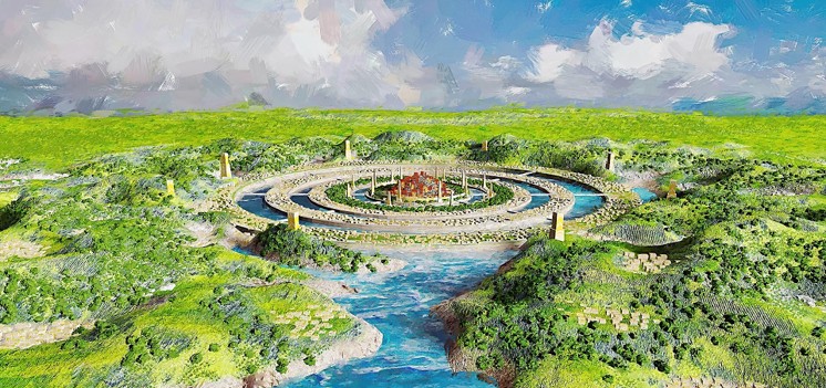
- For as long as humans have looked across the sea, we’ve imagined what might lie beneath it. Some stories are born from pure myth—like the legend of Atlantis, Plato’s tale of a grand, advanced civilization swallowed by the ocean. But sometimes, those ancient stories ripple forward in time, bumping into modern science in the most unexpected ways.
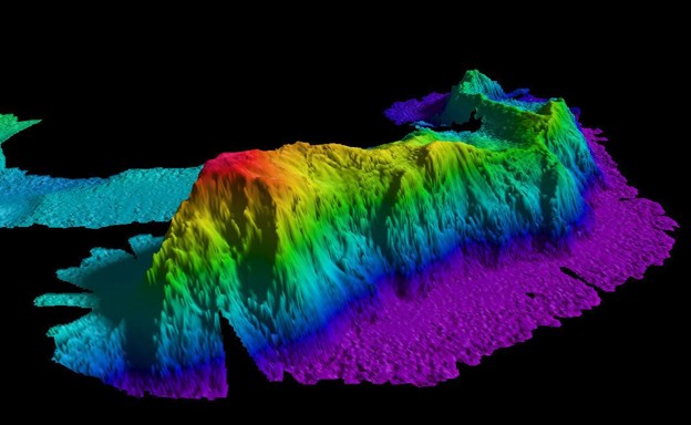
- That’s what happened in early 2024, when a team of Spanish scientists aboard the research vessel Angeles Alvarino was exploring the seafloor off the Canary Islands. Their goal wasn’t to find Atlantis. It was to map volcanic features using deep-diving remotely-operated vehicles (ROVs). What they found, however, was so dramatic in shape and location, it earned the mythic name—Mount Los Atlantes.
- Rising over 2 kilometers (1.2 miles) from the seafloor, this massive range stretches 110 km long—about the distance between New York City and Philadelphia.
- It consists of three ancient, extinct volcanoes, stitched together by eons of lava flow and tectonic motion.
- The summit of the range, although far beneath the waves today, shows a surprising detail: wind-sculpted dunes, sandy deposits, and even cliff-like structures.
- This puzzled the researchers. These features typically form above water, shaped by wind and wave, suggesting that the highest parts of Mount Los Atlantes may have once been an island.
- Could it have stood above the waves during an era of lower sea levels? Or was it pushed higher by tectonic forces before gradually sinking?
- And, of course, the questions everyone else asked, could it be Atlantis?
- Mount Los Atlantes is an example of a seamount.
- Seamounts are underwater mountains formed by volcanic activity, usually associated with tectonic plate movement or stationary hot spots in Earth’s mantle.
- Most never break the surface, but some were once islands before erosion and subsidence pulled them below sea level.
- There are over 100,000 estimated seamounts around the globe, but only a small percentage have been studied in detail.
Credit: By NOAA's National Ocean Service - Seamount, CC BY 2.0, https://commons.wikimedia.org/w/index.php?curid=120417754
.jpg)
- Mount Los Atlantes likely formed millions of years ago during intense volcanic activity in the eastern Atlantic, near what is now the Canary Islands.
- Over time, the volcanoes that created it became inactive. As the oceanic crust cooled and contracted, the structure slowly began to sink.
- Erosion and gravity also played a role, wearing down the peaks and causing soil, rock, and debris to fall down the seamount slope.
- Researchers observed features near the summit, roughly 200 feet below the ocean surface, that resembled wind-shaped dunes and wave-cut cliffs, typically found above sea level.
- This suggests that, at some point, the summit may have risen above the ocean’s surface.
- During the last Ice Age (~20,000 years ago), global sea levels were over 100 meters (330 feet) lower than today. A seamount now submerged could easily have been an island back then.

Credit: By Koppas - Own work, CC BY-SA 3.0, https://commons.wikimedia.org/w/index.php?curid=8902586
- The seamount lies “beyond the Pillars of Hercules” (many scholars today believe this was Plato’s term for the Strait of Gibraltar), which loosely aligns with the supposed location of Atlantis.
- Its grand, symmetrical appearance sparked media speculation and public interest.
- However, there is no evidence of any manmade structures or civilization on or around Mount Los Atlantes. The resemblance to Atlantis is purely coincidental.
- This isn’t the first time people have linked underwater formations to Atlantis. In 2009, grid-like patterns on Google Earth led to viral claims of a sunken city, which turned out to be data artifacts from sonar scanning.
- In 1931, even the respected Woods Hole Oceanographic Institution set off on a 42-day research cruise to study ocean currents near the Azores, but also to scrape off the surface of the seafloor to look for the lost continent.
- Modern tools along with the ROVs allowed the researchers to visually explore the seafloor and gather data.
- Unlike sonar mapping, ROVs provided high-resolution video and physical observations of the terrain, leading to the identification of geological features.
- This approach allowed scientists to observe fine-scale details that could have been missed by sonar, like sediment layers and slope patterns.
- ROVs collected soil and rock samples, analyzed the water for methane and carbon dioxide, and looked for evidence of important metals like manganese and cobalt.
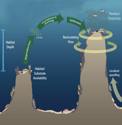
- Although seamounts like Mount Los Atlantes are hidden from view, they are important to study and understand.
- Knowledge from this research contributes to the understanding of the volcanic history of the eastern Atlantic and the geologic evolution of seamount chains. Research helps geologists reconstruct sea-level changes and tectonic processes in the region over millions of years.
- Seamounts affect ocean currents and are navigation hazards, especially for submarines. Only a small percentage of these have been fully studied and mapped.
- Seamounts are also considered biodiversity hotspots, supporting a wide variety of life in a diverse range of habitats.
- Corals and sponges act as foundation species, providing habitat and food sources for many other species.
- The complex currents around seamounts bring nutrient-rich water from deeper levels, stimulating plankton growth and supporting a wide array of life.
- Seamounts have high levels of endemism, meaning many species are found only in or around them.
Credit: Factsheet: Seamounts – Oases of Life; NOAA.gov
- Could Mount Los Atlantes have once been the mythical, revered city of Atlantis?
- The answer, scientifically, is no. There is no evidence of human settlement or ruins or lost technology, just rock, sediment, and volcanic structures shaped by nature.
- But the legend’s shadow gave this discovery a public spotlight and an opportunity to explore how Earth’s surface transforms over time, creating, submerging, and reshaping entire landscapes.
Episode script
In 2024, Spanish oceanographers studying the deep seafloor west of the Canary Islands discovered an enormous seamount --
A mile-high, 70-mile long mountain on the bottom of the ocean, formed of three inter-linked ancient volcanoes.
At its summit, just 200 feet beneath the water’s surface, they found sand dunes and cliff faces that could only have been formed if it had once been above water.
During the last Ice Age, when Earth’s water was locked up in continental ice sheets, sea level was over 300 feet lower.
Meaning that at least 100 feet of the seamount would have risen above the water, to form an island many miles long
It was almost directly west of the Straits of Gibraltar – exactly where Plato had described the city of Atlantis, before it sank beneath the waves.
Could it be? These scientists began to wonder, had they accidentally discovered the lost city?
They sent down the ship’s ROVs – Remote Operated Vehicles, to explore the surface of the seamount.
They found sediments and other evidence of erosion, only possible if the island were indeed above water.
But unfortunately, no ruins of an ancient city, or any evidence of human habitation.
Their continued research did provide valuable data about the volcanic past of the eastern Atlantic, the geologic formation of seamounts, and how they impact ocean currents – their original mission.
But Atlantis remains elusive, perhaps waiting for future scientists.