Just over 30 years ago, the Loma Prieta earthquake shook Northern California, killing 63 people and injuring almost 4,000 more.
It got Californians dreaming about an earthquake early warning system. Even a few seconds of lead time would allow people to stop what they’re doing, drop to the ground, and take cover, or pull over if driving.
To build this system, three large technological challenges had to be overcome.
First, the state installed hundreds more seismometers and electronically connected them.
Next, it had to write a complicated computer algorithm that could use data from just a few of these seismic stations to instantly calculate the epicenter of the quake and predict where its shock waves would travel, how quickly, and at what magnitude.
The system could do this by reading fast-moving compression waves, which arrive well before the more dangerous shear waves—the ones that cause the surface to jump and buckle.
Finally, they needed a way to get this information instantly out to citizens. So, on the 30-year anniversary of Loma Prieta, California launched a smartphone app called MyShake.
Alerts can go immediately to any smartphone, even using the phone’s location data to calculate how much shake the user would experience, and when.
The system can now provide minutes of warning. For instance, people in LA would know 2 minutes before shear waves from San Diego reach them. And that’s plenty of time to save many lives in the next big quake.
Background
Synopsis: In October 1989, Northern California’s magnitude-6.9 Loma Prieta Earthquake caused dozens of deaths and thousands of injuries. On the 30th anniversary of the disaster, the state of California launched MyShake, a statewide earthquake early warning app that delivers U.S. Geological Survey (USGS) ShakeAlert warnings to residents’ mobile devices throughout the seismically active state.
- October 17, 1989. It was the beginning of the third game of the 1989 World Series between the Oakland Athletics and their cross-bay rivals, the San Francisco Giants. The A’s were up two games to none. As fans gathered around their television sets waiting for the first pitch in the live broadcast from Candlestick Park in San Francisco, the Loma Prieta segment of the San Andreas Fault System slipped.
- This segment of the fault system had been fairly quiet until foreshocks in June 1988 and August 1989 warned of renewed activity.
- At 5:04 p.m. Pacific time, a magnitude-6.9 earthquake rattled the region, causing 63 deaths and 3,757 injuries.
- Concrete crashed down from the top of the stadium onto Candlestick Park’s upper deck, and the power went out.
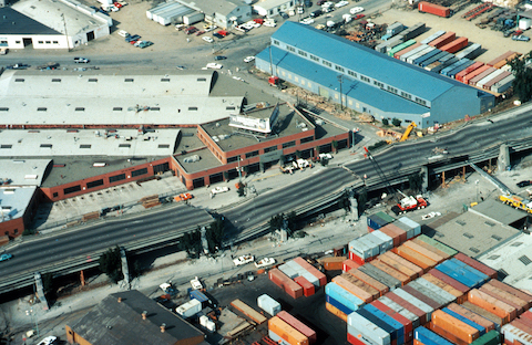
- A double-decker section of the Nimitz Freeway (I-880) collapsed and was where most of the earthquake’s fatalities occurred. Had more people been on the roads in rush-hour traffic rather than watching the game, the death toll could have been far worse.
- Santa Cruz and Monterey Counties, nearest the epicenter, suffered heavy damage, but landslides and liquefaction were seen as far north as San Francisco and Oakland.
- Residents of California, Oregon, and Washington always live with the risk of earthquakes, especially along the San Andreas Fault. But what if they could get advance warning of a quake?
- For decades, scientists laid plans for earthquake early warning systems. They needed to figure out how to identify earthquakes in seconds, rule out false alarms, and get immediate alerts to the public.
- First, scientists needed a large seismic network to detect earthquakes in fractions of a second.
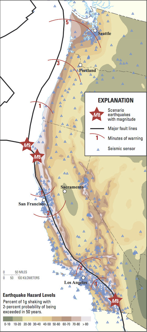
- Over the years, seismometers were installed in the region by USGS, CalTech, and the University of California, Berkeley. Concentrated in California, especially near population centers, more than 800 of these sensitive detectors actively inform a USGS early warning system called ShakeAlert.
- Sensors are also being placed in Oregon and Washington. Ultimately, the West Coast of the United States will be monitored by more than 1,675 sensors, plus the thousands of additional sensors that have been placed by other regional seismic networks.
- Second, scientists needed computer algorithms that could use the data received to instantly characterize the earthquakes, ruling out false alarms.
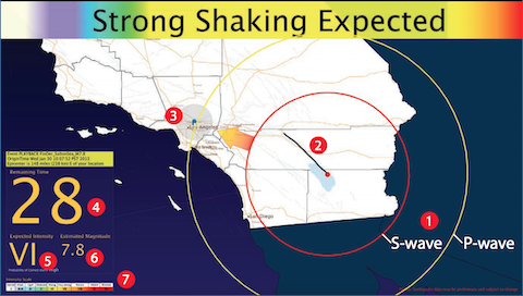
- When four or more instruments sense an earthquake, computer programs use the frequency and travel time of the fast-moving compressional P waves to calculate the quake’s epicenter and magnitude. This can now be done so quickly that alerts can be sent out before the intensely destructive, but slower moving, S waves arrive.
- The USGS’s ShakeAlert EEW System creates an alert that goes to businesses, mass transit and emergency services.
- The third and final piece of the puzzle was a way to get that information out to the public instantaneously. Most people carry a mobile device these days, so what they needed was an app!
- Seismic waves travel quickly, in the realm of kilometers per second, but smartphone GPS signals travel faster and reach masses of people simultaneously.
- In January 2019, the City of Los Angeles launched a pilot program called ShakeAlertLA for residents. A key test was to learn how fast the app could deliver emergency messages simultaneously.
- Residents of LA were alarmed to find they weren’t warned when the magnitude-6.4 earthquake rocked Ridgecrest in July 2019, just 150 mi (240 km) from the LA metro area. However, the app is designed to alert residents to strong shaking in their specific locations, and the Ridgecrest quake did not shake the LA area hard enough to trigger an alert. So, the app performed as designed.
- On the 30th anniversary of the Loma Prieta earthquake, October 17, 2019, California Governor Gavin Newsom launched the MyShake app for all residents of California.
- Beyond the technical challenges the researchers solved, there were also social challenges with deploying an early warning system.
- How big do earthquakes need to be to warrant an alarm in a particular location?
- Emergency managers must set alert thresholds for magnitude and intensity approaching a smartphone’s specific location. But as earthquake detection evolves, warnings may change.
- Presently, MyShake is set to notify people in areas where magnitude-4.5 or larger earthquake shaking is expected, but these thresholds can be adjusted in the future by emergency managers.
- Injuries can be reduced with even a few seconds of warning. Trains can stop running, airplanes can stop taxiing, and electricity or gas plants can shut down to prevent fires.
- What happens in the case of a false alarm?Too many false alarms from an early warning system may cause citizens to become complacent.
- However, a few false alarms can benefit the population by giving them a chance to practice for a future real event.
- How can emergency managers communicate warnings to everyone?
- Even if users are not looking at their phone, they will hear “Earthquake. Drop, cover, and hold on. Shaking expected.”
- To be most effective, warnings need to be provided early enough for people to act. People need time to take cover, pull to the side of the road, stop surgical incisions, put down dangerous work materials, and relocate away from tall racks in stores and warehouses.
- How big do earthquakes need to be to warrant an alarm in a particular location?
Credit: By Erin R. Burkett, Douglas D. Given, and Lucile M. Jones, USGS
- Both Mexico and Japan have existing earthquake early warning systems that have worked during quakes but also given false alarms.
- In September 2017, when a magnitude-8.2 earthquake occurred off the southern coast of Mexico, people got 90 seconds of warning. But 2 weeks later, they didn’t get an alert for another quake until after shaking had already started because the epicenter was much closer.
- In February 2018, the 4,000 seismometers in Japan’s warning system provided as much as 75 seconds of warning via the SkyNet app on Japanese smartphones before shaking commenced.
- Early warning systems have the potential to save many lives, and their development will continue as technology and innovation make them faster and more reliable. Maybe one day they will even use signals from the accelerometer in your smartphone as part of their incoming dataset.
- Always heed emergency warnings and buy yourself seconds by staying alert. Remember to drop, cover, and hold on!
- Drop to the ground. Don’t try to run outside; you could be hurt by falling debris.
- Take cover by getting under a sturdy desk or table. Protect your head and neck.
- Hold on until the shaking stops.
- If you are in a car, pull over and stay in it. Avoid parking under highway bridges.
- If you are near the sea and the shaking lasts more than 20 seconds, evacuate to high ground immediately (at least 2 mi [3 km] inland) in case of a tsunami.