It seems that Australia’s modern highways may have been laid out according to the stars.
Australian Aboriginals, like many ancient cultures, have an elaborate oral history passed down through generations to help them navigate and find food and water in their desert environment.
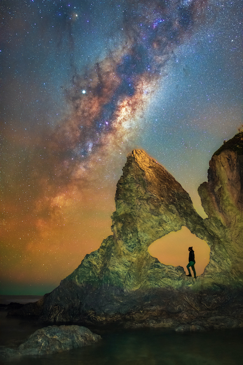
This knowledge base uses visual memory aids from the land… and the sky.
When ancient aboriginal navigators found a successful path through the desert, they looked for a path in the stars that mimicked it.
They’d use stars to represent water holes and hilltops and gave them the same names.
At night, they could point out the star patterns to others who had never made the trip, describing the path from one waypoint to the next.
To help travelers remember the maps, First Nation clans preserved them in song, which they could sing along their journey to recall place names, orientations, and distances. In the process, they taught these songs—and the star maps they reflected—to younger generations.
This navigation tool, used by First Nation tribes for millennia, was only disclosed to researchers a few years ago. Many of these so-called “songlines” are still used in Aboriginal treks today.
And when researchers laid the songlines over a modern map of Australia, they found that many highways appeared to line up with the star patterns.
These roads were set along cattle trails established by early immigrant ranchers who were probably following songlines shown to them by Aboriginal guides.
Background
Synopsis: The rich oral histories preserved by the indigenous peoples of Australia cover learnings collected over tens of thousands of years. Without written libraries, the amazing memory of aboriginal groups is stored in their ancient “songlines”—memory aids which pair places with specific vivid and detailed memories through rituals of stories, song, dance, and art. Using the starry skies as their blackboard, elders even created songlines describing imaginary navigational tracks from star to star to provide clan members with mental maps to new earthly destinations. Remarkably, the spatial orientation of some ancient star maps can be laid directly over satellite images of Earth, matching Australia’s modern highway system.
- The First Nations people of Australia (sometimes referred to as Aboriginal Australians) are believed to be descendants of 1–3 large waves of early migrants from Africa that reached the continent 50–70,000 years ago.
- Today, only about 3.3% of Australia’s population (about 800,000 people) identify as indigenous, but they represent more than 500 nations (clan groups) that speak more than 300 languages.
- Australian aboriginal groups have recorded the longest continuous history on the planet. But their early nomadic members didn’t have libraries, paper maps, or GPS. Instead, their knowledge of history and geography is recorded in oral stories and songs, as well as in their art and dance.
- Clan members can remember amazing volumes of knowledge by using an ancient memory code known as “songlines.”
- Songlines include words, rhythms, and melodies, and are extremely memorable because their lessons are built on mythology and ceremony.
- Songlines tie positions in a landscape to vivid memories, making use of the hippocampal link between human memory and spatial perception.
- Portable artfully decorated message sticks may also reinforce the memories.
Credit: Australian Geographic
- Some songlines have been passed among broad networks of aboriginal groups spanning hundreds of miles.
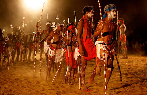
- Aboriginal clans meet for gatherings called corroborees to exchange stories and knowledge.
- Even among tribes with different languages, songlines will use similar-sounding lyrics and rhythms, though their melodies might vary.
- The memories are so clearly remembered and communicated that 21 different communities have relayed separate stories describing a scientifically documented sea-level rise that occurred in the region 7,000 years ago.
- Songlines have a variety of topics. Some describe how the land, animals, and natural processes were created by the ancient spirits. Others describe past historical events. Many stories relate to social law and tradition, similar to fables.
- Many songlines impart practical knowledge about a clan’s surroundings. Some are about the seasons as well as flora and fauna, including medicinal remedies. Songlines about animal behavior are commonly practiced before a hunt to remind the group of dangerous actions to watch for in their prey.
- Still other songlines tell tales that provide mental maps used for navigation with star maps to show the way, as described to researchers by Michael Anderson (tribal name Ghillar), an Euahlayi activist and tribal leader from the northeastern state of Queensland. With star maps and songlines, groups can successfully navigate the treacherous Australian countryside.
- At gatherings, elders teach navigational tracks for new destinations to younger clan members using the spatial relationships between certain stars in the night sky, with each star representing a specific natural landmark along the way.
- Each landmark is described in an accompanying songline which specifies rituals rooted in mythology to be undertaken upon reaching the waypoint, solidifying the significance and memories tied to that specific location by prior generations.
- Clan members can be taught how to navigate a voyage to a place they have never visited, sometimes even being taught star maps of the winter sky for a voyage in the summer. The voyagers must remember the precise relative positions of the winter stars for a successful summer trek, since the star map may not rise in the summer sky.
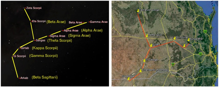
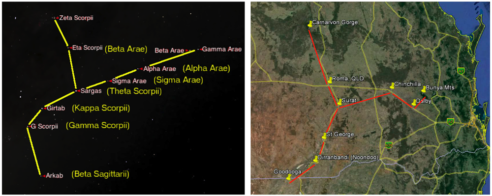
The positions of some landscape features and stars in the Milky Way that have been woven into songlines also correspond to modern highways. Credit: Robert Fuller and Google Maps
- Recent research has revealed an even more astonishing fact about star maps.
- If a star map is captured in a photo from the ground, then laid on satellite images of Earth, the spatial relationship of the stars in the star map corresponds with the locations of landmarks and modern towns on Earth.
- The distances between waypoints and the direction of turns required to arrive at the next waypoint for the voyage from the star maps directly overlay the modern Australian highway map.
- European explorers employed aboriginal guides to learn about Australia. They were followed by drovers, then settlers who established towns.
- Researchers believe aboriginal guides used star maps and songlines to guide the Europeans, ultimately guiding the locations of Australia’s towns and roadways.